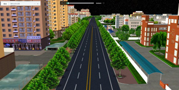
The 2D&3D Sand Table Information System Platform applies 3D true-color accurate terrain sand tables, the Internet of Things and other information technology.
03 Mar,2020Many cities and districts across the country has take communities and villages as the important control and management sectors in epidemic management.
19 Feb,2020During the Chinese Spring Festival, SuperMap has turned the epidemic prevention and controlling projects into the highest response level.
19 Feb,2020Aiming at the characteristics of large investment scale, short construction period, and difficult terrain in construction projects, a set of project management platforms based on GIS + BIM technology were developed.
18 Feb,2020The city digital plan and management platform is built to standardize the construction of fire rescue plans and consolidate the information operation.
10 Feb,2020Based on virtual reality technology and taking data as core, process as clue, special event as driven, the city fire hydrant water monitoring system integrates GIS, Internet of Things, artificial intelligence, data visualization, automation control and ot…
05 Feb,2020Through the integration of BIM, GIS, and IOT technologies, the comprehensive and visual representation of sky, ground, and underground multi-source data can be achieved, an intelligent decision-making model library can be built, a model management system …
13 Jan,2020The Pearl River Delta Water Resources Allocation Project includes a main line, two secondary lines, a branch line, a regulating reservoir, and three lift pumping stations. The total length of the water conveyance line is 113.1km, which is the largest wate…
07 Jan,2020The cross-sea tunnel project is the first super-cross-sea project in China to pass through a karst-developed area with a large diameter.
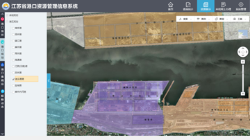
04 Dec,2019Based on the concept of measurable and controllable management of port resources, the port management information system integrates various port resources to create port one-map
18 Oct,2019