With the development of various <br/>digital technologies, three-dimensional geographic information <br/>technology has gradually merged with new-generation information <br/>technologies such as big data, artificial intelligence, 5G and <br/>blockchain, a...
26 Aug,2024Combined with its own technical and business advantages in geographic information, digital twins, GeoAI and other fields, and in cooperation with Hohai University, Nanjing Normal University, Nanjing University of Posts and Telecommunications and other wel…
24 May,2023Sichuan spans China's first and second-level landform steps. With mountains and hills widely distributed, frequent seismic activities, complex and changeable climate, it is the province with the largest number of geological disasters in China. In…
17 May,2023An overview of Smart Park platform With the rapid development of information technology, IoT, mobile Internet and cloud computing technologies, "Smart Park" is enabled to provide various services for park planning and design, construction a…
08 May,2023The “Digital Chaohu” platform is built on the basis of SuperMap GIS, using multi technologies such as 2D-3D integrated GIS, spatio-temporal big data, remote sensing image analysis, and drone aerial photography. With departmental data sharing as the core…
05 May,2023The smart airport digital twin solution integrates cutting-edge technologies such as the Internet of Things, big data, BIM, GIS, and artificial intelligence. By establishing a complex relationship between airports in the physical world and virtual space t…
18 Apr,2023Based on Leaflet and SuperMap iClient JavaScript 10i (2020), E-Hualu has developed an integrated green transportation project of the geographic information platform for Yinchuan City. It is constructed with a modern Web technology stack, integrating …
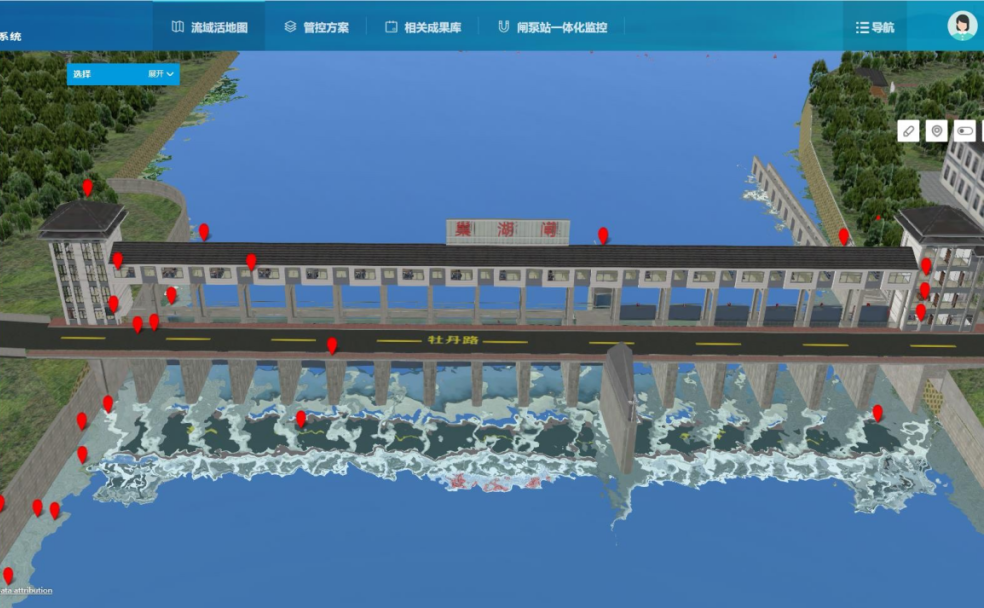
14 Apr,2023The digital twin river basin is the core of smart water conservancy. The full-space digital twin technology helps to integrate the spatial data of the river basin and build the base of the platform scene in an all-around way.Relying on the self-developed …
13 Apr,2023Dituhui SAAS platform assists catering companies in choosing new sites by displaying various data with geo-intelligence and conducting the analysis of the three key points of opening a store:1. Store location management2. Neighboring competitors3. Potenti…
28 Mar,2023IntroductionThe “Smart Field” product launched by Dituhui (part of SuperMap) focuses on the fieldwork of the enterprises, intelligently strengthens the management and control of the work out-of-office process and results, and can assist enterprise manag…
24 Mar,2023