Establish a framework for natural resource application systems based on digital twin technologyIn the field of natural resources, the application of digital twin technology in the field of natural resource survey and monitoring and real estate registratio…
14 Feb,2023The Lhasa Municipal Natural Resources Bureau has built a set of integrated natural resources management models with snow-covered plateau characteristics based on the overall construction framework of one network, one map, one platform, and N applications,…
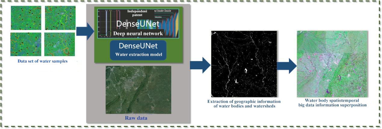
29 Jan,2023Based on the remote sensing data of the Gaofen-2 satellite, Unionbigdata has built a big data analysis system for remote sensing of rivers and lakes in Chengdu for the Chengdu Smart Governance Center. The core mechanism is that water that is clean, malodo…
01 Nov,2022Yilong Lake is a typical plateau shallow lake. Due to its proximity to the urban construction area and the serious damage to the ecological environment in the early years, although the ecological environment of Yilong Lake has been effectively managed for…
10 May,2022Korea Forest Service(An independent agency specializing in forestry that is overseen by the South Korean Ministry for Food, Agriculture, Forestry and Fisheries)Forest disaster integrated management systemForest disaster integrated management system can mi…
06 Apr,2022In recent years, information technology has gradually stepped into the intelligent era. Natural resources have also been set a higher demand in supervision. Since its development by Guotu Information in 2017, a part of SuperMap, "Land-protecting Smar…
28 Mar,2022Wetlands are always ecologically fragile and monitoring and early warning are indispensable in their conservation. SuperMap and its partner Attiot jointly constructed a wetland ecosystem monitoring and early warning platform for Poyang Lake, the largest f…
26 Jan,2022In recent years, China has attached great importance to the management of natural resources. In 2015, the national underground water project was officially launched. SuperMap Group has undertaken the task of constructing information systems related to hyd…
12 Apr,2019The SuperMap new generation 2D+3D natural resource information management platform can realize the overall cognition of the national land space system, manage the land space, improve the ecosystem service capabilities, and promote high-quality development…
25 Mar,20191 Forestry GIS for forest protectionGeographic information is highly important for forest workers. 'High precision positioning portable device for forestry GIS'is developed based on SuperMap iMobile for Android, applying for Android devices with G…
10 Mar,2019