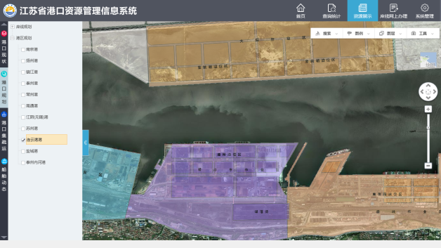
Based on the concept of measurable and controllable management of port resources, the port management information system integrates various port resources to create port one-map and realizes the visualization, diversification and integration of the port resource management through the tagging of port, port area, operation area, operator, dock berth, anchorage, shoreline and other features. Also through regular updated image maps, the system can view the current status of the port construction, conduct the comparison analysis of the planning and design layers of ports and port areas, and greatly strengthen the means of resource utilization supervision.
(1) Through the graphical, digital, and visual methods, the visualize, intensive, and dynamic management of the port infrastructure resources (shore lines, port areas, terminals, berths, and public infrastructure) can be achieved.
(2) It dynamically displays and manages the port-related data such as safety data and major sources data.
(3) It realizes the data exchange with Maritime Bureau, and dynamically displays the geographic information data, AIS dynamic data, ship visa information and video supervision information of maritime issues.
(4) It provides research and development strategies and plans for the port management and decision support for the effective integration and allocation of port resources.
(5) It provides necessary data and technical support for improving the management of port resources, and promotes the port information constriction in building a smart port.

1. The system highlights
(1)Port resources one-map
The various resources (business and themes) of the port can be integrated and widely shared to create a “port resources one-map”.
(2) Targeting of business supervision
Through the regularly updated image map, the system can view the current status of the port construction, conduct the comparison analysis of the planning and design layers of ports and port areas, and greatly strengthen the means of resource utilization and supervision in shoreline utilization, port area planning and construction supervision, port operation supervision and port operation permit supervision.
1) Through the comparative analysis of the port function layout plan and the regularly updated image, it is easier to find out whether the port construction meets the planning requirements.
2) Through the dynamic information of the actual arrival of ships, it can effectively monitor the phenomenon of under-reporting dangerous goods, and whether the supervision of the operation exceeds the scope of business license by comparing the actual transportation goods.
2. The diversified display methods
It can comprehensively display the electronic maps, high-definition images, 2.5-dimensional, vector plots, pictures, videos, tables, graphics, etc.
Satellite Tracking + Big Data GIS Application in Real-time Ship-controlling>
Big Data - Signaling Data Makes Cities Smarter>