SuperMap logo
  • Products

    What is GIS

    About SuperMap GIS

    Technology System

    • Big Data GIS
    • New RS Software
    • New 3D GIS
    • Geospatial AI
    • Distributed GIS
    • Cross Platform GIS

    SuperMap GIS 2024 New!!

    • Cloud GIS Server
    • Edge GIS Server
    • Terminal GIS for Desktop
    • Terminal GIS for Components
    • Terminal GIS for Web
    • Terminal GIS for Mobile

    Previous Versions

    • SuperMap GIS 2023
    • SuperMap GIS 11i(2022)
    • SuperMap GIS 10i(2021)
    • SuperMap GIS 10i(2020)
    • SuperMap GIS 10i
    • SuperMap GIS 9D(2019)
  • Solutions

    Smart City

    Natural Resource

    Land Management

    Facility Management

    Public Safety

    Natural Disasters

    Transportation

    Water Conservancy

    BIM+GIS

  • Stories
    • Articles
    • News
    • Events
    • Magazines
  • Support
    • Download & Online Help
    • Online Demonstration
    • Ask & Answer
    • Discover SuperMap GIS
    • Trial License
  • About
    • lntroduction
    • Careers
    • Contacts
    • Suggestions
 
  • English
  • 中文
  • Español
  • Français
  • ภาษาไทย
  • русский
  • Türkçe
  • Português
  • 日本語
  • 한국어
  • Indonesian
  • عربي
Natural Disasters

Natural Disasters Solutions

  • Home
  • Solutions
  • Natural Disasters

Natural Disasters

  • BIM
  • Disasters
  • Land
  • Water
  • Transportation
  • Safety
  • Facility
  • City
  • Resource
  • An early warning system helping prevent and relieve geological disasters in Sichuan province

    Sichuan spans China's first and second-level landform steps. With mountains and hills widely distributed, frequent seismic activities, complex and changeable climate, it is the province with the largest number of geological disasters in China. In…

    17 May,2023
    An early warning system helping prevent and relieve geological disasters in Sichuan province
  • Heavy rain, drought, high temperature... Let the data "speak" to improve the prevention and management of meteorological disasters

    Meteorological disasters feature a wide range of influence, high frequency of occurrence, and large losses, accounting for more than 70% of China's natural disaster losses.With “integration” as the guiding idea for construction, cloud-based arc…
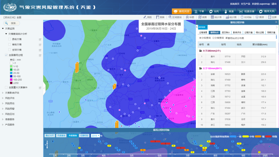
    01 Feb,2023
    Heavy rain, drought, high temperature... Let the data "speak" to improve the prevention and management of meteorological disasters
  • SuperMap GIS Solutions for Meteorology

    SuperMap's meteorological industry solutions cover meteorological data processing, display, analysis and meteorological and climate services. The main platforms include:Disaster risk survey system and disaster risk management system involving the whol…

    11 Jan,2023
    SuperMap GIS Solutions for Meteorology
  • Looking for Disaster “Lurker”, Air-space-ground Integration Makes Hidden Dangers Invisible

    In the investigation of geological disasters, it is necessary to keep an eye on the "old problems" and find out the "new hidden dangers" generated by the development. "Where are the hidden dangers of earth disasters?" "W…

    22 Nov,2022
    Looking for Disaster “Lurker”, Air-space-ground Integration Makes Hidden Dangers Invisible
  • “1+1+N” Mode to Digitize Geological Disaster Prevention and Management

    Utilizing technologies of GIS, 5G, Internet of Things, big data, digital twins, SuperMap geological disaster prevention and management platform adopts the “1+1+N” model: one geological disaster big data center, one geological disaster prevention basic i…
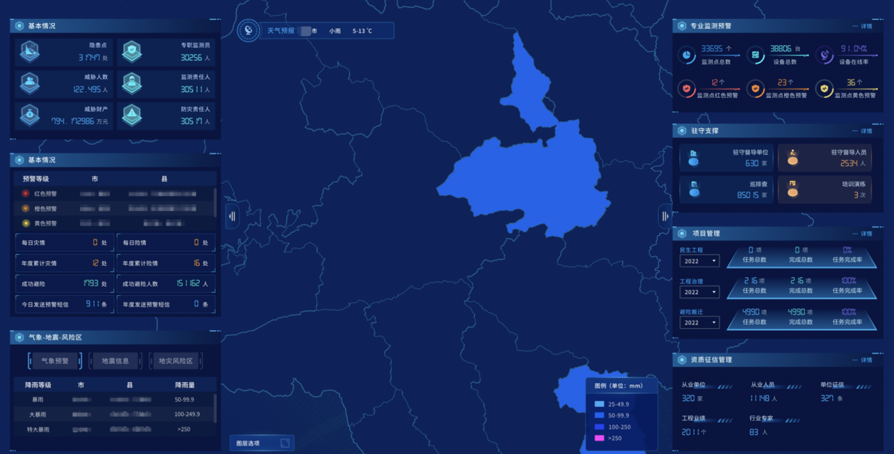
    28 Oct,2022
    “1+1+N” Mode to Digitize Geological Disaster Prevention and Management
  • “One Map” Solution for Natural Disaster Prevention, Mitigation and Relief in Cities

    The frequency of natural disasters brings obstacles to the rapid development of cities. A key point in building a “smart city” is how to “smart” deal with natural disasters’ impacts on cities. Natural disaster prevention and mitigation is an importan…

    01 Jul,2022
    “One Map” Solution for Natural Disaster Prevention, Mitigation and Relief in Cities
  • Natural Disaster Spatial Information Service Platform

    Construction backgroundSpatial information is vital in natural disaster management and disaster prevention and mitigation. Although some information service systems have emerged in recent years, there is no unified planning for each system, and there is a…

    16 Jun,2022
    Natural Disaster Spatial Information Service Platform
  • The Flood Defense Visual Command Platform for Yongji County

    SuperMap has partnered with Jilin Fengsheng Software Technology to build the Yongji County Flood Defense Visual Command Platform based on SuperMap10i product.Yongji County(Source: WWW.JLYJ.GOV.CN)Its main functions include basic map operations, such …

    05 May,2022
    The Flood Defense Visual Command Platform for Yongji County
  • Practice and Exploration of Human-Technology Management Pattern for Geological Disaster Monitoring and Early Warning

    Tongchuan geological disaster monitoring and early warning management platform integrates human work and technologies, innovating geological disaster monitoring methods and prevention measures, and improving the early detection and early prevention of geo…

    15 Feb,2022
    Practice and Exploration of Human-Technology Management Pattern for Geological Disaster Monitoring and Early Warning
  • SuperMap Forest Disaster Management System in Korea

    Forests play a special role in reducing various natural disasters. The quantity and quality of forest resources not only affect the economic development of a country or a region, but also the ecological development and human survival.In order to better im…

    04 Jul,2019
    SuperMap Forest Disaster Management System in Korea
<<< < 1 2 > >>>

SuperMap GIS

  • Cloud GIS Server
  • Edge GIS Server
  • Terminal GIS for Desktop
  • Terminal GIS for Components
  • Terminal GIS for Web
  • Terminal GIS for Mobile

Stories

  • Articles
  • News
  • Magazines
  • Events

Support

  • Download & Online Help
  • Online Demonstration
  • FAQ
  • Demo Code
  • Technical Docs
  • Training Files
  • Videos
  • Trial License

Events

  • [list:pagetitle] [list:targetlink]
  • {/zzz:list}

About

  • lntroduction
  • Careers
  • Contacts
  • Suggestions

Follow Us

  • LinkedIn
  • Facebook
  • Twitter
  • Instagram
  • YouTube
© 1997-2023 SuperMap Software Co., Ltd.
  • Sitemap
  • | Privacy