The comprehensive information system of the North Jiangsu Canal covers the 400 kilometers of the north section of the Beijing-Hangzhou Grand Canal, as well as 11 cascades and 28 ship locks.
09 Sep,2019Pingshan District of Shenzhen is one of the first batches of 90 national smart city pilots of the Ministry of Housing and Urban-Rural Development. As a capability platform supported by the concept of “Wise Pingshan”
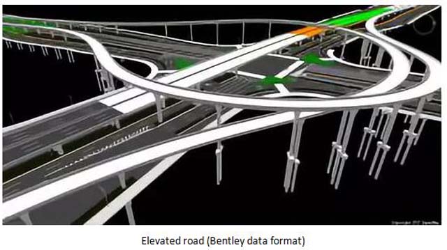
09 Sep,2019Based on the Dassault ENOVIA platform, the project accurately models the second ring viaduct through CATIA, and superimposes BIM on GIS to realize the visual management of the road and viaduct with SupreMap GIS.
06 Sep,2019BIM technology keeps developing and being applied in a lot of industries, such as planning, real state, architecture, water, electricity, transportation and so on. This is a new challenge to the 3D GIS. The 3D spatial information needs to make a closed lo…
06 Sep,2019The viaduct of the Second Ring Road is the first full-viaduct expressway built in the downtown area of Chengdu City. It has a total length of more than 50 kilometers with huge amount of facilities and complex structures. Due to the unexposed information a…
06 Sep,2019Currently, GIS technology has been widely used in building information management, urban information management, such as grid system, public information system, etc. Based on the GIS technology, the public information and management information of control…
06 Sep,2019The engineering progress management platform integrates Internet+ Technologies, such as BIM + GIS. It can be applied to the dynamic management of various large-scale building complexes and large-scale parks or zones, for instance, the Shanghai Qiantan Int…
06 Sep,2019The Smart Engineering Supervision Platform utilizes BIM, GIS, Internet of Things, big data, intelligence, mobile communication, ERP and other key technologies to integrate project management, video management, Internet of Things platform, big data platfor…
05 Sep,2019GIS technology provides strong technical support for the basic information platform of land spatial in planning, management, decision-making, service, etc. Based on the management demand of 2D and 3D integration of natural resources, the application of Su…
05 Sep,2019The 3D underground pipeline system was established based on the site survey and data sorting.
30 Aug,2019