bool(false) Terminal GIS for Mobile Overview and Features - SuperMap GIS 2023 - SuperMap GIS Software

Overview

It is a mobile GIS software development platform based on map browsing, data collection, data analysis, and route navigation and combined with AR maps, mobile 3D, cloud collaboration, etc. It is used for rapid development of online, offline, 2D, 3D mobile GIS applications, and provides advanced, professional and intelligent mobile GIS services for professional data collection product developers, industry mobile GIS product developers, and application mobile GIS product developers.

Features

Map browse

  • Supports local data source.
  • Supports multiple OGC services, XYZ services, SuperMap iServer REST map services and data services.
  • Supports third-party map services such as Sky Map, OSM, etc.
  • Supports importing more than 20 common vector and raster data.
  • Supports raster map tiles and vector map tiles.

AR map

  • Supports KML data format files, video datasets, and 3D point, line, and surface datasets loading.
  • Supports label thematic map, custom style, and automatic text avoidance.
  • Supports adding maps, images, videos, text, sandbox, models, charts, 3D, etc. to AR scenes.
  • Supports AR point cloud, dotting, and trajectory data collection.
  • Supports AR intelligent recognition such as target recognition, license plate recognition, stereo recognition, etc.
  • Supports AR 3D viewshed analysis and sectioning analysis.
  • Supports excavation and roller modes for viewing hidden facilities in AR module.

Data collection

  • Supports the collection of vector data such as points, lines, and surfaces through gestures and GNSS.
  • Supports collection and editing of attribute tables.
  • Supports the collection of multimedia data such as pictures, videos, and sounds.
  • Supports graphic editing tools such as cutting, merging, erasing, etc.

Navigation map

  • Supports self-collection of road data for path analysis and navigation between two or more points.
  • Supports indoor cross-floor path and indoor and outdoor integrated pathanalysis and navigation.
  • Supports editing and compiling road network, and the compiled road network directly participates in route planning and navigation.

Data analysis

  • Supports terrain analysis such as slope, aspect, and surface area.
  • Supports vector analysis such as buffer analysis, overlay analysis, network analysis, etc.
  • Supports data registration and projection conversion.

Online services

  • Supports path analysis, travel agent analysis, and logistics distribution analysis services published by SuperMap iServer.
  • Improves the upload and download performance of SuperMap iServer data services by 5x+.
  • Supports map services, data services, real-time streaming services, and distributed analysis services published by SuperMap iServer.

3D

  • Supports loading and display of 3D point, line, polygon datasets, and kml data.
  • Supports S3M tile data loading such as white modeling model data, high-precision city model data, BIM, oblique photography 3D model, point cloud, topology network data, vector data, etc.
  • Supports measurement, cropping, viewshed analysis, visibility analysis, skyline analysis, 3D Spatial query, model explosion, etc.
  • Support tracking object movement in dynamic camera layer.
  • Support for OBB bounding box for terrain image.
  • Support PBR material for 3D pipeline.

Thematic mapping

  • Supports thematic map types such as segment, label, single value, etc.
  • Supports more than 10 kinds of charts such as area chart, ladder chart, line chart, scatter chart, rose chart, etc.
  • Supports heat maps, grid heat maps, density maps, aggregation maps, relationship maps.

Overview

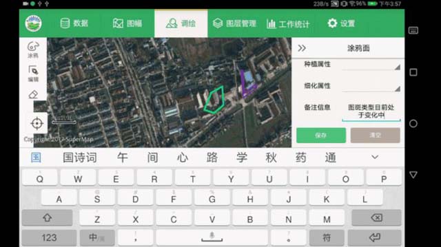
It is a lightweight mobile GIS development package for online applications, providing open source Android/iOS APIs. It supports multi-source online map accessing, diverse map visualization effects, professional GIS data collection, and online analysis services.

Features

Basic capabilities

  • Supports measurement, coordinate conversion, and spatial relationship operations.
  • Supports flexible layer operation and interaction, including layer hiding, adding, deleting, order adjustment, fast positioning, etc.
  • Supports range query, distance query, geometric and SQL query, and attribute query.
  • Supports thematic maps such as point density, level symbols, labels, section, single value, grid section, grid single value, etc.

Development framework

  • Micro development library.
  • Supports open source (address: https://github.com/SuperMap).

Base map data and analysis services

  • Supports REST map and analysis services published by SuperMap iServer.
  • Supports third-party map services such as sky map.
  • Supports MVT vector tile service.

Overview

It is a lightweight, low-power mobile GIS development package with rich online GIS functions, multiple map visualization effects, professional GIS data collection, GIS message interconnection and collaboration among multiple devices, map card atomization, and online analysis services. It is used to develop GIS products suitable for Harmony microkernel, such as watches, glasses, televisions, tablets, mobile phones based on Harmony system.

Features

Harmony microkernel

  • Supports the development of Harmony microkernel for Huawei Harmony watches, mobile phones, AR glasses, televisions, etc.
  • Supports map service cards for quick switching and browsing of maps.

Map visualization

  • Provides online map services, including services published by SuperMap iServer, SuperMap Online and third-party services.

Data collection

  • Supports collection of point, line, polygon, trajectory, etc.
  • Supports attributes collection.
  • Supports SuperMap iServer data service and Spatial analysis service accessing.

Support

Demo Code
Technical Docs
Training Files