IntroductionChengdu Main Urban Zone Fresh Food Cold Chain Service System is an award-winning work of the SuperMap GIS Contest. This work takes the fresh food cold chain service system in the main urban area of Chengdu as the object, based on relevant data…
08 Feb,2023The goal of the systemGuangdong Weihao Intelligent Technology Co., Ltd. and SuperMap cooperated to build a campus security system for Huazhong Agricultural University. Based on three-dimensional geographic information, the project integrates equipment, pi…
19 Dec,2022SuperMap Underground Parking Lot Solution integrates map, positioning and navigation. The parking lot application based on this solution can solve the difficulty in parking, finding cars and car management in the indoor parking lot through the pipeline sy…
25 Oct,2022The urban drainage pipe network system has a large coverage area and vast amounts of equipment, making daily maintenance and repair a high workload. A municipal drainage network information system is developed to tackle problems in managing the drainage n…
16 Sep,2022SuperMap and Shuifa Smart Agricultural Technology jointly developed the Shandong (Province) Pesticide Supervision Map. By collecting, processing, managing, retrieving and analyzing the data of enterprises that produce and sell pesticides, this map assists…
08 Sep,2022With the increase of gas users and the operating time of indoor gas facilities, gas safety defense is one of the top priorities of urban management. Since 2021, SuperMap has used digital twin technology to create the Qingtian County “Gas Safety All-in-On…
26 Jul,2022The underground pipeline network is the “lifeline” of a city. The pipeline network facilities are concealed and spatially complex. As a result, when the urban pipeline network is under repair or operation, excavation bursts, inspection misses, repeated …
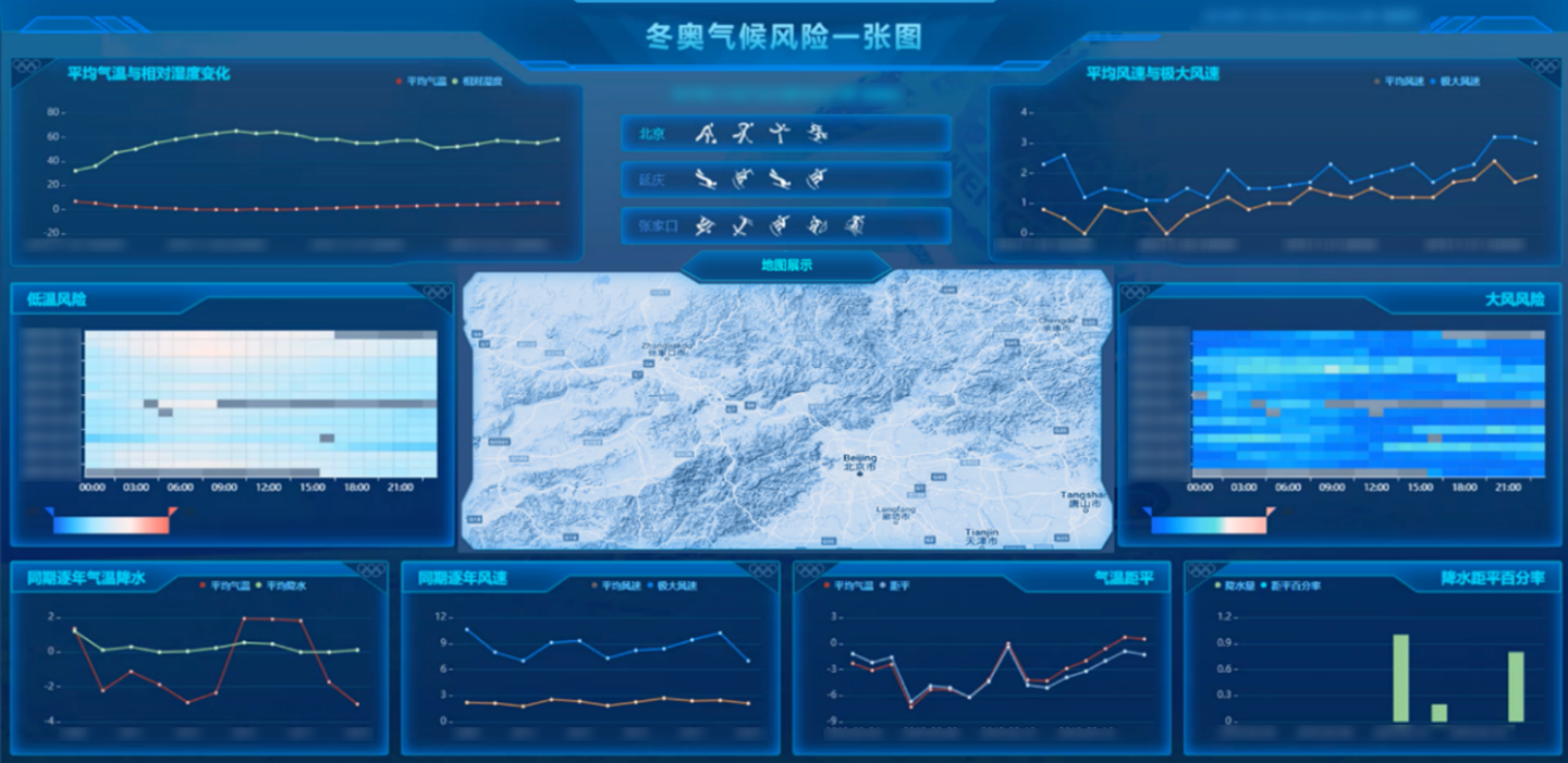
27 Apr,2022The 24th Olympic Winter Games was held in Beijing and Zhangjiakou (in north China’s Hebei Province) on February 4, 2022. Compared with the Summer Olympics, the Winter Olympics, especially the snow sports held outdoors, are more susceptible to weather con…
07 Feb,2022The underground pipeline plays a vital role in ensuring urban operations. AR + GIS assists the application of 3D pipelines and empowers the intelligent inspection of 3D pipelines.
25 Mar,2020The underground pipeline information management platform is based on GIS technology, which adopts C/S, B/S hybrid network technology, and integrates 2D and 3D integrated technology, 3D visualization technology, big data storage technology, high-performanc…
15 Oct,2019