SuperMap Underground Parking Lot Solution integrates map, positioning and navigation. The parking lot application based on this solution can solve the difficulty in parking, finding cars and car management in the indoor parking lot through the pipeline sy…
25 Oct,2022The Honghe Area (part of Yunnan Province Pilot Free Trade Zone), relying on the provincial geological big data service platform and based on the new generation of 3D GIS technology of SuperMap, has developed a digital 3D one-map management system. This sy…
19 Oct,2022Introduction The BIM Management Platform for Power Grid Planning and Construction in Xiong'an (hereinafter referred to as the "platform") is a digital power grid planning and management platform that comprehensively uses BIM, GIS, big data a…
13 Oct,2022The Xiaoshan District geographic information service platform collects various spatiotemporal information about the region in real time, integrates the operation spatial data of various local departments, mines the spatial application data, and provides c…
11 Oct,2022Poyang Lake Eco-Tech Zone, with a total planned area of 158.53 square kilometers, is an innovation center of the local city. The informatization of geospatial data is of great significance for promoting the economic development of the park. A GIS service …
23 Sep,2022The urban drainage pipe network system has a large coverage area and vast amounts of equipment, making daily maintenance and repair a high workload. A municipal drainage network information system is developed to tackle problems in managing the drainage n…
16 Sep,2022SuperMap and Shuifa Smart Agricultural Technology jointly developed the Shandong (Province) Pesticide Supervision Map. By collecting, processing, managing, retrieving and analyzing the data of enterprises that produce and sell pesticides, this map assists…
08 Sep,2022SuperMap and Bolijiang 3D Technology jointly developed a Sand Table and 2D-3D Integrated Information System platform for the central areas of Lanzhou City.The platform adopts a 3D true-color accurate terrain sand table, IoT, etc., and runs the basic infor…
07 Sep,2022The Natural Resource Protection Supervision Platform has been used in many cities to supervise the protection of the Yangtze River waters. Based on remote sensing technology and GIS technology, build an information management service platform for the Yang…
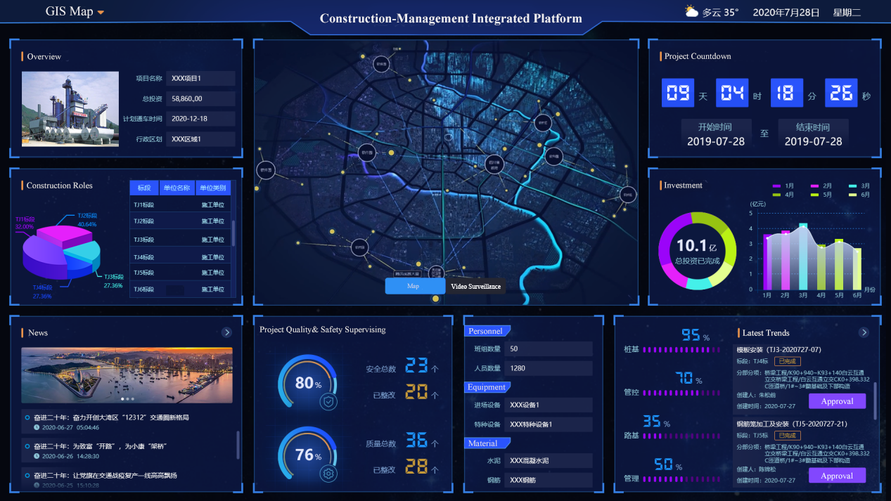
06 Sep,2022The Highway Construction-Management Integrated Platform based on GIS fully applies mobile Internet, Internet of Things, GPS, face recognition, QR code, etc. This system runs through the entire project construction cycle and involves data collection, on-si…
05 Sep,2022