In SuperMap GIS 2024, SuperMap Software has further innovated the six major technical systems of GIS platform software (BRT-IDC), namely Big Data GIS, New Remote Sensing Software, New Three Dimension GIS, Geospatial AI, Distributed GIS, and Cross Platform GIS technology systems.
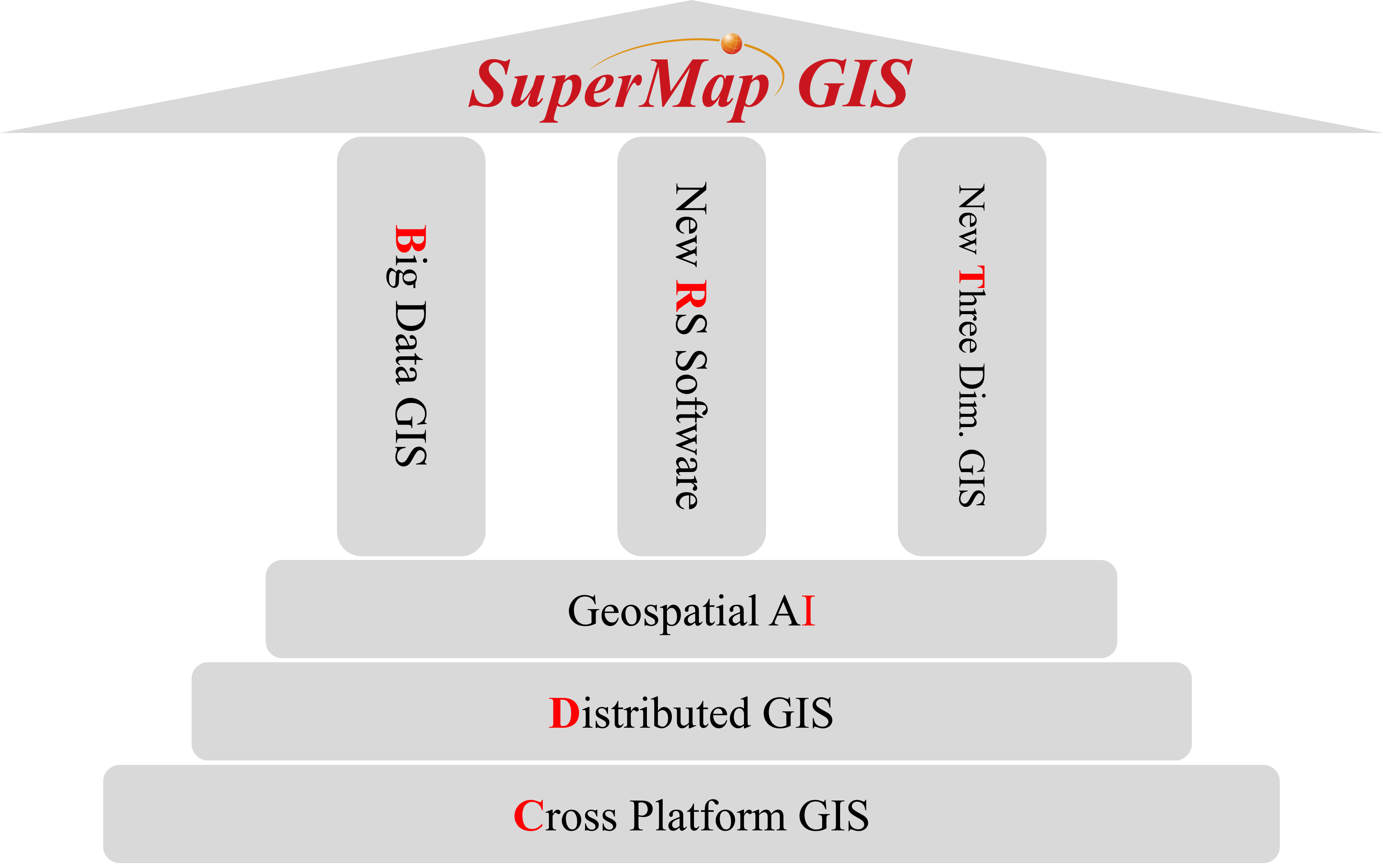
SuperMap GIS 2024 Technology Systems (BRT-IDC)
The big data GIS system includes the storage and management of geospatial big data, geospatial analysis, streaming data processing and visualization technology, dedicates to providing a comprehensive support for big data GIS infrastructure software and services, and making more users easily manage geospatial big data "gold mine".

Big Data GIS Technology System

◇ Provides HBase and HDFS engines for large scale raster data.
◇ Provides Elasticsearch engines for streaming data.
◇ Supports customized extensible geospatial big data storage engine.
◇ Supports direct connection to Yukon (Yugong) and Neo4j graph databases for entity/relationship storage.

◇ Kernel level extended Spark geospatial data model.
◇ Supports 6 categories covering 200 kinds of geospatial big data analysis operator.

◇ Supports building entities and relationships based on structured data.
◇ Supports entity/relationship construction from structured data.
◇ Supports geospatially-enabled knowledge graph entities with map-view synchronization.
◇ Supports knowledge graph querying and analyse.
◇ Supports data lineage from processing automation workflows to graph databases for traceability and tracking.

◇ Integrated open source map development library (OpenLayers, Leaflet, MapboxGL JS) and visualization library (ECharts, MapV, DECK.GL).
◇ Provides 2D / 3D and dynamic / static visualization effects.
◇ Provides spatial big data visualization technologies such as scatter map, heat map, honeycomb map, grid map, trajectory map, O-D map, flow map, etc.
◇ Provides interactive knowledge graph visualization.

◇ Provides built-in spark clusters and external spark cluster.
◇ Supports Hadoop cluster YARN mode.
◇ Supports 4 Spark deployment modes: local (single-process), local (multi-process), client, and cluster.
The new remote sensing software technology system integrates internationally leading photogrammetry core algorithms, breaking through intelligent technologies such as the pre-trained large imagery model (LIM). It covers the full process capabilities of remote sensing image data storage management, production processing, interpretation and analysis, and visualization. This framework pioneers advancements in distributed high-performance computing, integrated remote sensing & GIS processing, cross-platform software compatibility, intelligent processing/interpretation, cloud-native architecture transformation and web-based interoperability. Through algorithm optimization and technical integration, it significantly enhances remote sensing image processing efficiency, interpretation accuracy and T+1 rapid application of data products.

New Remote Sensing Technology System

◇ Supports processing of common satellite remote sensing data: GF-1/2/6/7, ZY-1 02C/02D/02E, ZY-3 01/02/03, BJ-2/3A/3N, JiLin-1, Sentinel-2, Landsat7/8/9, IKONOS, WordView, SPOT5, Pleiades-1, SuperView-1, SuperView Neo-1.
◇ Supports AI-based multi-source image matching models to enhance feature point quantity/quality in feature-poor regions like deserts, Gobi, etc.
◇ Supports AI-driven non-ground feature filtering to eliminate points on clouds/building roofs, improving geometric correction accuracy.
◇ Supports automatic ground control point matching for images with significant initial positional deviations, boosting automated processing success rates.
◇ Supports import of field-collected high-precision control points for high-quality DOM production under sparse control conditions.
◇ Supports incremental aerial triangulation adjustment to ensure multi-batch output accuracy consistency.
◇ Supports image registration capability to align multispectral imagery with corrected panchromatic references.
◇ Supports batch orthorectification with zonal output functionality.

◇ Supports orthorectification, correcting the position and geometric distortions of original images based on adjusted RPC parameters.
◇ Supports image fusion algorithms such as Gram-Schmit and Pansharp, enabling users to control the sharpening effects of image fusion.
◇ Supports color output, synchronously adjusting image bit-depth and band sequence, enhancing color representation and feature recognition in vegetated areas.
◇ Supports multiple color balancing methods like uniform balancing, color mapping, adaptive balancing for diverse scenario requirements.
◇ Provides auto mosaic line generation avoiding buildings/cloud zones while optimizing paths along features like roads/rivers.
◇ Supports output of result data in whole, standard subset, and polygonal clipping formats.
◇ Supports cloud removal by intelligently identifying cloud distribution for rapid cloud-free DOM production.
◇ Supports haze removal, automatically enhancing contrast by removing haze from images.
◇ Supports registration of generic geographic imagery using mathematical models like polynomial, thin-plate spline, RPC reverse calculation, etc.

◇ Supports point cloud generation by performing dense matching on stereo images, producing dense point cloud data. Includes built-in AI dense matching models to effectively reduce mismatches.
◇ Supports dense matching of stereo imagery to generate dense point cloud data.
◇ Provides AI-powered dense matching models reducing mismatches and void areas for more natural-looking DSMs with sharper contours.
◇ Supports automatic DSM generation.
◇ Supports DSM filtering with automatic DEM output
◇ Provides AI filtering models adapted to complex terrain, enhancing processing in mountainous/urban areas.
◇ Supports DSM merging, combining multiple tiles of data into a single DSM covering the entire area.
◇ Supports DSM water elevation correction by automatically adjusting water surface heights based on water vector data.

◇ Supports planar and seam accuracy checks, displaying inspection points through thematic maps for visual assessment of result accuracy.
◇ Supports regional accuracy checks, facilitating detailed zone inspection of entire images.
◇ Supports deformation detection, automatically extracting areas with terrain, road, and building deformations.

◇ Supports generic radiation calibration models.
◇ Supports the 6S atmospheric correction model.
◇ Supports atmospheric correction for satellite sensor data from GF-1/2/6/7, ZY-3 02, ZY-1 02D, Sentinel-2, Landsat8/9, etc.

◇ Supports image interpretation tasks including scene classification, change detection, object detection, binary classification, object extraction, and land cover classification across various scenarios. Supports image super-resolution reconstruction.

◇ Provides ready-to-use pre-trained models for typical scenes like forest, farmland, urban water bodies, and urban buildings.
◇ Supports Large Imagery Model (LIM) for high-precision land cover classification in remote sensing interpretation.
◇ Supports G-SAM for fine-grained image segmentation by incorporating semantic information through spatial cues.
It is based on 2D & 3D integrated GIS technology, including 2D and 3D integrated data models and analysis calculations, multi-source 3D data storage management, multi-source 3D data sharing and interoperability, and multi terminals rendering interaction and output. It supports the storage, management, computation, analysis, visualization, and publishing of massive 3D data to achieve outdoor and indoor integration, macro and micro integration, and aerospace/surface/underground integration, and empower the application of full space new 3D GIS.

New 3D GIS Technology System

◇ Supports 2D data models such as 2D points/lines/surfaces, 2D networks, irregular triangulation networks, grids, etc.
◇ Supports 3D volume data model, and supports boundary notation and parametric notation.
◇ Supports 3D network data model, and supports indoor, outdoor, and overground and underground 3D network analysis.
◇ Builds two types of 3D field data models: Irregular Tetrahedral Grid (TIM) and Voxel Grid, and supports temporal dimensions.
◇ Provides rich analysis and calculation functions for 3D surface data, 3D volume data, 3D field data, etc.
◇ Supports symbolic modeling, rule-based modeling, and parametric modeling, and supports rapid construction of large-scale 3D scenes based on vector data.
◇ Provides operational functions such as stretching, dimensionality reduction, voxelization to achieve mutual conversion between 2D and 3D data models.
◇ Added corridor modeling tools enabling rapid 3D utility tunnel model generation through aligned model placement.
◇ Added LOD 2.1 building model generation with authentic textures using building footprints and oblique photography models

◇ Fully integrates multi-source heterogeneous data such as oblique photography 3D models, laser point clouds, BIM, GIM, white architecture model data, high-precision city model data, 3D fields, geological bodies, terrain, underground pipelines, etc.
◇ Supports direct access to data that meets standards such as IFC, CityGML, Geo3DML, GIM, etc., and supports cross-platform direct import of IFC (Industry Foundation Classes) data and storing them as different data types based on their classifications.
◇ Fully supports BIM data and access multiple formats of BIM data produced by over 10 mainstream BIM software. Added support for cross-platform direct import of RVT (Revit) data and DGN (MicroStation) data, including importing native BIM family component tree information.
◇ Provides multiple distributed GPA tools to realize efficient full process management and spatial analysis of 3D data such as white architecture model data, high-precision city model data, BIM, oblique photography 3D model, point cloud, terrain, etc.
◇ Added incremental update support for oblique photography 3D models/BIM/fine models within arbitrary extents, enabling partial updates of BIM/fine models by business IDs.

◇ Supports the surveying and mapping industry standard Spatial 3D Model Tile Data Format (Surveying & Mapping Standards), Spatial 3D Model Data Format (S3M) and Spatial 3D Model Data Service Interface, along with providing corresponding open resources.
◇ Supports the sharing and interoperation for white architecture model data, high-precision city model data, oblique photography 3D model, point cloud, BIM, GIM, 2D/3D point/line/polygon data, 2D/3D topological network data, geological body, 3D field in multiple terminals.
◇ Supports S3M 1.0, S3M 2.0 and S3M 3.0 format.
◇ Added I3S 1.7-2.1 to S3M 3.0-3.01 conversion compliant with GitHub community standards.
◇ Added 3D Gaussian Splatting to S3M 3.01 conversion capability.
◇ Added multi-temporal S3M tile generation with multi-element multidimensional feature information.

◇ Desktop 3D Rendering Engine V2 adds volumetric clouds, height-based fog, and ambient occlusion technologies, enhancing scene immersion through realistic atmospheric and lighting effects.
◇ Provides proprietary WebGL/WebGPU clients and Cesium-based WebGL clients with full-data support, full functionality, high realism, and low-code development capabilities.
◇ Enhanced scene rendering in proprietary WebGL/WebGPU clients supports water refraction, flow direction arrows, high-fidelity water effects, volumetric clouds, height-based fog, and light beams.
◇ Proprietary WebGL/WebGPU clients add S3M tile feature-level editing like add/delete/scale/translate/rotate/replace objects.
Proprietary WebGL client achieves 25+ FPS loading for city-level fine/untextured/oblique models in domestic hardware/software environments.
◇ Provides a high fidelity 3D GIS development package based on UE4/UE5/Unity/HMS Core 3D Engine, and supportsdynamic loading of large-scale, multi-source 3D GIS data, as well as multiple 3D GIS analysis, query, and measurement.
◇ Provides 3D GIS data beautification tools to achieve high fidelity rendering of 3D scenes (UE4/UE5/Unity).
◇ Supports cloud rendering to web terminal, provides open source JavaScript APIs, and supports low code development (UE4/UE5/Unity).
◇ Supports multiple VR/AR/MR devices:Oculus Quest2, iPhone, Microsoft HoloLens2, etc.
◇ Supports 3D printing.

◇ Provides 3D geographic design WebApp, supporting online batch modeling and interactive editing.
◇ Provides the iEarth WebApp for 3D Earth, supporting rapid setup of visual scenes, and enabling online browsing, querying, analysis, and sharing of scenes.
◇ Provides SuperMap iExplorer3D, and supports access to massive multi-source heterogeneous spatial data and high-fidelity 3D fields rendering.
◇ Supports 3D GIS cross platform.
Geospatial AI (Geographic Information AI) refers to the integration of artificial intelligence with geographic information software technologies. SuperMap AIF serves as the technological foundation for spatial intelligence, providing various AI capabilities including ready-to-use functionalities and customizable training and fine-tuning tools through AI process tools. SuperMap AIF empowers SuperMap's foundational software products and applications in industries such as natural resources information technology.

Geospatial AI Technology System

AI Workflow Tool
◇ Supports batch generation of training data during the data preparation stage.
◇ Supports training of multi-band remote sensing image interpretation models, along with capabilities for transfer learning and continuation training during the model construction stage.
◇ Supports various inference scenarios such as batch processing and range-based processing. Also includes capabilities for model eva1uation and conversion during the model application stage.
AI Remote Sensing Image Processing
◇ Built-in AI heterogeneous image matching models enhance the accuracy of matching different source images.
◇ Provides AI heterogeneous image matching models to enhance feature point matching quantity and quality in feature-poor regions like deserts, Gobi, etc.
◇ Eliminates non-ground feature points on the clouds/building roofs using AI-driven semantic data to improve geometric correction accuracy.
◇ Provides cloud detection AI models for intelligent cloud distribution identification enabling rapid cloud-free DOM production.
◇ Provides AI dense matching models effectively reduce mismatches, improving the quality of Digital Surface Model (DSM) outputs.
◇ Built-in AI filtering models adapt to complex terrain conditions, particularly suitable for DSM filtering in urban areas.
◇ Provides AI filtering models adapt to complex terrain conditions, and optimizes filtering effectiveness in mountainous/urban areas.
AI Remote Sensing Image Interpretation
◇ Supports binary classification, land cover classification, general change detection, object detection, object extraction, scene classification, and other multi-scene image interpretation. Supports image super-resolution reconstruction.
◇ Provides pre-trained models for various land covers such as forest land, farmland, urban water bodies, and urban buildings.
◇ Supports remote sensing interpretation pre-trained large model (LIM) capable of high-precision land cover classification.
◇ Supports G-SAM, enabling fine-grained image segmentation and the incorporation of semantic information through geographical prompts.
AI 3D Data Processing and Analysis
◇ Provides functionality for precise instance segmentation of point clouds, enabling accurate identification of objects such as power lines and towers.
◇ Supports automatically extracting building outlines and identifying roof details, supporting the bulk construction of complex building entities.
AI Spatial Analysis
◇ Supports clustering analysis, including spatial hotspot analysis and spatial density clustering.
◇ Supports classification analysis capabilities, including map matching, address feature recognition, and forest-based classification.
◇ Supports regression analysis features such as geographically weighted regression, linear regression, and logistic regression.
AI Image/Video Analysis
◇ Supports image classification and object detection.
◇ Supports video Analysis, including capabilities for object detection, object tracking, object counting, speed analysis, geofencing, fight detection, license plate recognition, and supports custom sample training for video object detection models.
AI Image Generation
◇ Supports image generation feature and custom prompt words. It combines multiple reference images with various attribute constraints to generate intended images. These constraints include: sketch, outline, depth, line segment, semantic information, doodling, color, and lighting effects.
◇ Supports local redrawing for custom prompts. This feature enables users to combine smudging, clicking, or text prompts to segment target areas for redrawing.
◇ Supports super-resolution reconstruction, enabling customizable high-definition image enlargement using AI algorithms to enrich fine details in the image.
◇ Supports fine-tuning image generation styles based on a small number of target style images. This feature allows for customizing generated image styles through refined model training.
AI Q&A
◇ New intelligent Q&A function for supporting batch upload of typical text materials such as doc, excel, pdf, etc., to build industry knowledge bases or provide fixed URLs. Based on a large NLP model, it enables the creation of custom scenario Q&A and supports answer tracing.
◇ Supports intelligent Q&A function.Users can batch upload typical text materials such as doc, excel, pdf, etc., to build industry knowledge bases or provide fixed URLs. Provides semantic search, knowledge tracing, Q&A, and multi-turn Agentic RAG conversations based on a large NLP model.
◇ Added model management and domain knowledge base management modules.
AI Knowledge Summarization
◇ Supports knowledge summarization function for uploading lengthy text materials. Based on a large NLP model, it provides functionalities such as summary generation, meeting minutes generation, topic analysis, long-text Q&A, and text profiling.

SuperMap AgentX Server (Beta)
◇ Provides multi-modal agent services including Chatflow Agent, Workflow Agent, and Autonomous Agent.
◇ Compatible with leading open-source models (Baichuan, ChatGLM, Qwen, DeepSeek) and cloud AI services (Tongyi Qianwen, ERNIE Bot, OpenAI).
◇ Integrates SuperMap domain knowledge base with custom knowledge base support for business-aligned tool orchestration.
◇ Added Model Context Protocol (MCP) standardizing geospatial agent tool interfaces with internal/external tool integration.
SuperMap TransformX
◇ Added AI Assistant enabling intelligent model construction via natural language interaction.
SuperMap IDesktopX
◇ Supports functionalities including AI remote sensing image processing, remote sensing image interpretation, spatial analysis, automated AI-driven 3D model construction, image analysis, and video analysis.
◇ AI Assistant now supports interactive Q&A retrieva1, GPA model building, and intelligent mapping through natural language commands.
SuperMap iServer
◇ Supports functionalities including AI remote sensing image processing, remote sensing image interpretation, spatial analysis, automated AI-driven 3D model construction, image analysis, and video analysis.
SuperMap ImageX Pro/Enterprise
◇ Supports capabilities such as AI remote sensing image processing and interpretation.
SuperMap iPortal
◇ SuperMap iPortal AI Assistant enables data retrieva1, analysis, visualization, portal management, and third-party extensions via conversational interaction with SuperMap AgentX Server.
◇ SuperMap iPortal AI Assistant now supports Agentic RAG capability, integrating knowledge retrieva1 with tool invocation.
◇ SuperMap iPortal AI Assistant implements GraphRAG technology with built-in GI tool knowledge graphs for reliable task recommendations.
◇ SuperMap iPortal AI Assistant added MCP protocol support, standardizing geospatial agent tool interfaces for internal/external tool integration.
◇ Map Studio introduces AI Cartography, enabling professional map generation, layer styling, layout/label/animation adjustments via natural language commands.
SuperMap iMobile
◇ Supports AI capabilities for object recognition, detection, tracking, and counting.

◇ For industries like natural resources informatization and water conservancy, SuperMap AIF's AI capabilities enable customized application development—e.g., creating intelligent Q&A systems via AI knowledge generation, producing AI-generated spatial planning images, and building water conservancy agent applications with geospatial agent technology—driving intelligent industry transformation.
It includes distributed geospatial data engine technology, geo-blockchain technology, distributed geospatial analysis and processing technology, cloud native GIS technology and edge GIS technology. It supports the storage, management, analysis, processing, visualization and publication of massive classic geospatial data and geospatial big data. Thus, it can realize the major breakthrough of GIS in high-availability, high-concurrency, high-performance, high-capacity and high-credibility to build a new distributed collaborative model of cloud, edge and terminal integrated GIS.

Distributed GIS Technology System

◇ Supports distributed geospatial file system, including HDFS, DSF, etc.
◇ Supports distributed SQL geospatial database.
◇ Supports distributed NoSQL geospatial database, including MongoDB, Elasticsearch, HBase, etc.

◇ Provides kernel level extended Spark geospatial data model.
◇ Supports more than 200 kinds of distributed processing automation modeling tools.
◇ Provides more than 70 kinds of distributed geospatial analysis operators.
◇ Provides the high-performance distributed dynamic rendering capability.

◇ Realizes the full microservice of map, 3D, big data,AI and stream data functions.
◇ Supports docker deployment and provides rolling upgrade, elastic scaling and error recovery of GIS node.
◇ Provides general automatic layout based on Kubernetes, which can realize the real time monitoring of all microservice resources.
◇ Integrated service grid technology supports gray publish, access control, service measurement, and service tracking.
◇ Integrates serverless technology, and supports running spatial analysis tasks, geographic processing automation tasks, distributed image cutting tasks and 2D/3D tile distribution tasksin a Serverless GIS function mode.
◇ Supports the use and conversion of cloud native GIS data formats and tile formats such as FlatGeobuf and PMTiles.

◇ Provides edge GIS products to build cloud, edge and terminal integrated application system.
◇ Supports pre-proxy, service aggregation, data distribution and analysis processing of edge GIS.
Since 2001, based on the standard C++, SuperMap has reconstructed the GIS kernel to build a set of native cross platform GIS technology system which has high performance and supports multiple CPUs, operation system has been established.
Now, SuperMap GIS supports multiple CPU architectures, like x86, ARM, MIPS, SW-64, etc. It can also run on Linux, Windows, Android and iOS with high-performance.

Cross-Platform GIS Adaptation (Partial)

◇ CPU, GPU, including AI chips.

◇ Linux, Windows, HarmonyOS, Android, iOS, etc.

◇ Relational type, NoSQL, etc.

◇ Cloud platform: public cloud, private cloud, etc.
