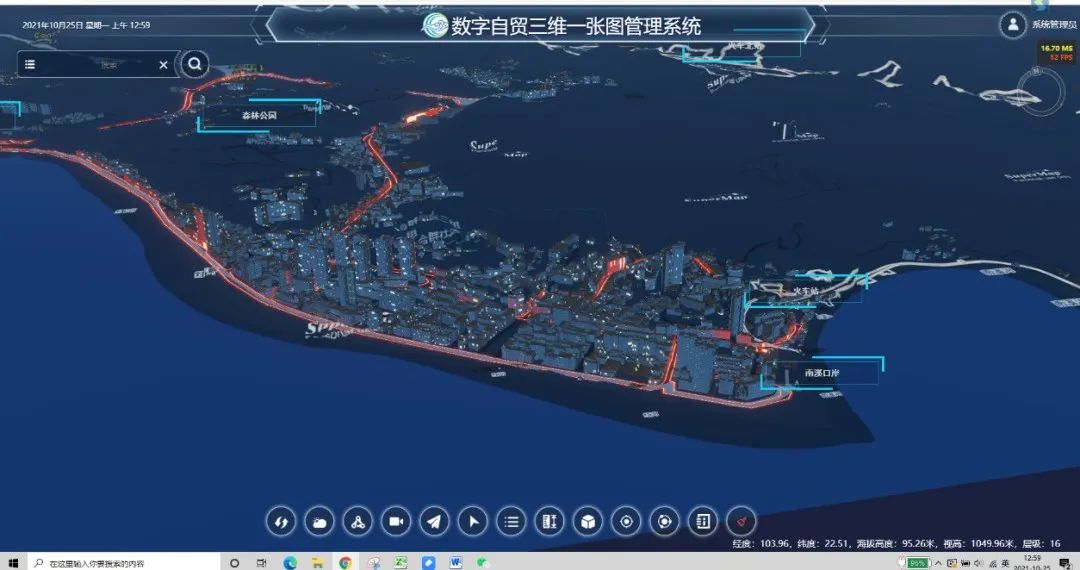
The Honghe Area (part of Yunnan Province Pilot Free Trade Zone), relying on the provincial geological big data service platform and based on the new generation of 3D GIS technology of SuperMap, has developed a digital 3D one-map management system. This system gives rise to more integrated and digital natural resources management, which assists local departments in planning and decision-making.
1. Multi-source data integration to build 3D real scenes
The system integrates high-precision terrain data and high-definition satellite remote sensing images to construct a terrain-level 3D scene in the Pilot Free Trade Zone, reflecting the geographical location and shape of the real world.
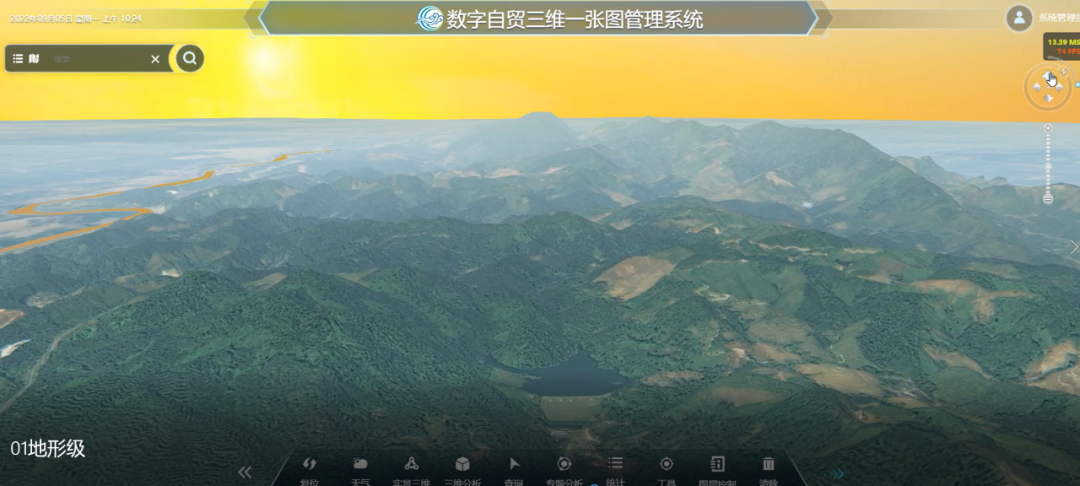
3D scene of terrain
The system integrates oblique monolithic models, orthophotos, rivers, etc. to construct city 3D scenes, and utilizes real estate registration data as the monolithic model base to dynamically query building information for refined expression and spatial statistical analysis, and refined service management.
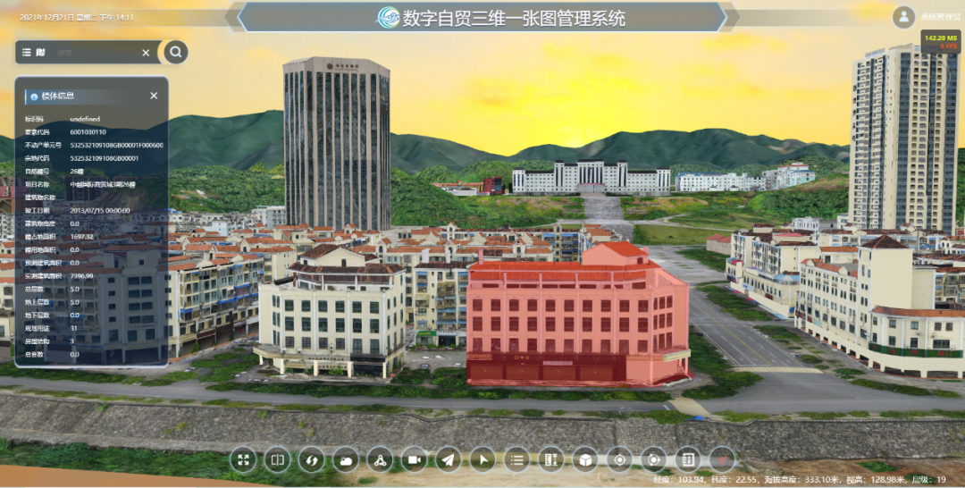
3D scene of city
The system integrates BIM models, oblique monolithic models, street lamps, trash cans, billboards, manhole covers, underground pipelines, etc. to build component real-world 3D scenes, accurately expressing the integration of ground and underground, indoor and outdoor integration, and supports property query of each component.
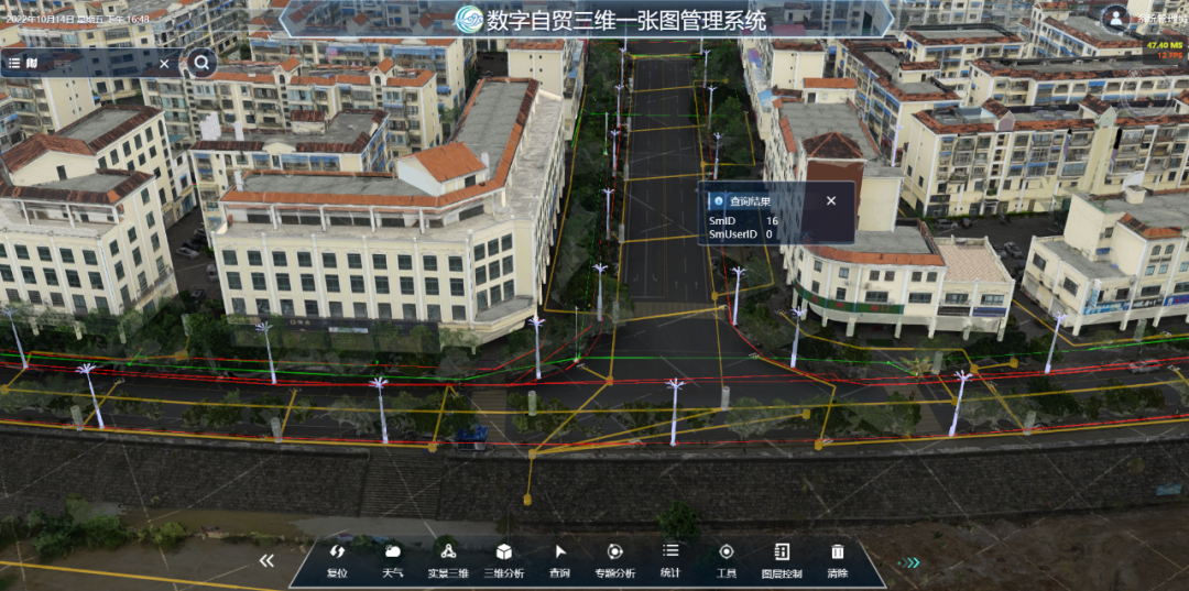
3D scene of component
The system supports effect simulation and beautification of 3D scenes and can simulate urban rain, snow and urban night scenes in real time, bringing users an immersive experience with 3D scenes.
City nightscape
2. 3D intelligent analysis to assist in urban planning management
Inundation analysis: According to the specified maximum and minimum elevation values and inundation speed, the system dynamically simulates the inundation process of the water level rising from the minimum elevation to the maximum elevation in a certain area, which is of great significance to flood control and disaster mitigation, flood risk analysis and disaster assessment.
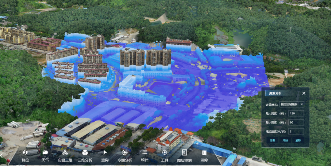
Inundation analysis
Visual field analysis: Based on a given observation point and observation range, the system analyzes whether the observed object within the observation range is visible. The 3D visual field has important application value in the layout of survey and monitoring facilities for natural resources.
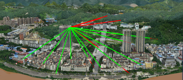

Visual field analysis
Excavation analysis: It is used to view the underground geological structure and underground pipeline network structure. It sets the excavation depth according to the buried depth of the pipeline, draws the range for terrain excavation, and supports attribute queries. It is used for urban pipeline network management, which is convenient for checking pipeline leakage and damage, timely maintenance, and reducing disasters.
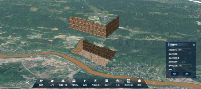
Terrain excavation
Height limit analysis: The building height is limited according to the requirements of the overall urban planning for the building height limit. It supports the visual expression of height restrictions in 3D scenes, and has practical application results in urban overall planning.

Height limit analysis
Analysis for assisting planning: The first is quantitative analysis, which includes 2D spatial data of building control lines, building density, plot ratio, green space ratio, facility configuration, land use property matching, and comparative display of traffic and commuting conditions to support the rationality comparison of quantitative analysis of the project. The second is qualitative analysis, including the analysis of the conformity of the architectural texture of the 3D space, the urban skyline and the view corridors, and the integration of the form, color, volume and surrounding of the building, etc. The intuitive 3D display can assist in decision-making.
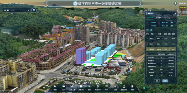

Ancillary services
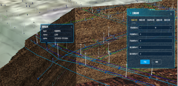
Geological body analysis: Explosion analysis of geological bodies can clearly and intuitively display the geological level distribution of complex geological blocks, to quickly understand the distribution of internal geological space or traffic streamlines. At the same time, it supports the sectioning, excavation, drilling, etc. of the geological body. Using the sectioning method, it is convenient and intuitive to observe and understand the stratigraphic structure of the section. It can be cut at any angle according to needs, and the attribute information of the section can be checked in real time.
Geologic body analysis
3. Multi-department sharing to empower smart city construction
The 3D one-map has rich data resources, an intuitive 3D format, and a high-precision model that fits the real scene. In terms of the display and expression of spatial elements, the spatial information of natural resources is abstracted into the 3D entity information that is visible to the human eye and readable to the machine. Its construction work runs through all stages, including collection, management, coding, display and analysis of real 3D data. A 3D space-time database covering all elements of mountains, water, forests, fields, lakes, grass, and sand can be formed, which can be shared and applied to emergency management, urban planning and design, smart city, etc.
For example, in emergency management, combined with 3D data to assist disaster impact analysis, it can provide support for emergency rescue and decision-making. In urban planning and design, it can simulate urban planning and construction scenarios, and support custom layout of 3D models such as buildings and infrastructure; through the gradual sharing of data among departments, this system facilitates digital twins to empower the construction of smart cities.
4. Summary and outlook
The 3D One-Map system unifies the natural resource data system and base with its features of "3D space" and "entity coding". It can comprehensively and truly reflect the actual situation of natural resources and the natural geographical pattern. It supports the informatization, intelligence and digitization of the Pilot Free Trade Zone. In the future, AI image recognition and knowledge map construction and analysis will be incorporated to facilitate the construction of a digital free trade zone.