
SuperMap GIS is a large-scale package of GIS platform software for 2D and 3D integrated spatial data acquisition, storage, management, analysis, processing, mapping and visualization, as well as a development platform for various industries.
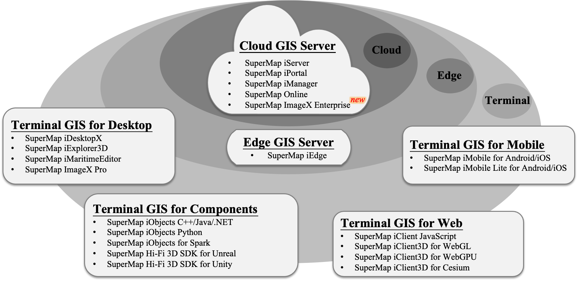
After more than 20 years of technological advancement, SuperMap has developed a cloud-edge-terminal integrated SuperMap GIS product architecture, including cloud GIS server, edge GIS server, terminal GIS, and SuperMap Online for online GIS services.
In SuperMap GIS 2024, a new remote sensing image processing server software product has been released, enhancing the capabilities of the cloud-edge-terminal GIS product series. This update further innovates the six major technologies system of GIS platform software (BRT-IDC), which include Big Data GIS, New Remote Sensing Software, New 3D GIS, Geospatial AI, Distributed GIS, and Cross Platform GIS technologies. These advancements enrich and revolutionize GIS theories and technologies, empowering digital transformation across various industries.

SuperMap GIS 2024 Product Architecture

◇ A new remote sensing image processing server software has been released. It is based on Web architecture, designed for automated production of massive optical remote sensing images (DOM) and intelligent image interpretation. It integrates cloud-native technology, supports distributed deployment, and multi-node operation, allowing for flexible and on-demand allocation of computing resources.
◇ The GIS server now supports rapid publishing of video data, providing capabilities for video data management, querying, and video file streaming.
◇ The GIS server's dynamic vector tile rendering performance has been significantly enhanced, with improvements of up to 200+ times under 16 concurrent requests.
◇ The GIS server's performance for publishing large MongoDB tile collections has been optimized. Following the publication of collections with tens of thousands of tiles, iServer startup time is now reduced to minutes.
◇ The GIS Operations Manager now supports visual deployment and uninstallation, offering a simple and efficient deployment experience.
◇ The GIS Operations Manager adds support for custom visual form-based site templates, enabling management indistinguishable from built-in sites.
◇ The GIS Edge Server now supports proxying GIS services in a cloud-native environment, providing enhanced flexibility and stability.

◇ Supports directly reading ShapeFile, FileGDB, GeoPackage, and other third-party vector data formats, reducing the need for data import processes.
◇ New cloud storage service capabilities for seamless integration with shared cloud data.
◇ New capabilities for database transaction management to ensure data consistency and integrity.
◇ Implemented dataset grouping to enhance the efficiency of data classification, management, and querying.
◇ Supports local updates of white model tiles generated by surface extrusion, including automatic edge processing for local updates of 3D models derived from oblique photography.
◇ New image distortion detection feature for Remote Sensing Desktop, that can automatically extract distortion areas in buildings, mountains, and roads, improving the efficiency of quality inspection.
◇ New functionalities for inspecting image plane accuracy and edge matching accuracy for Remote Sensing Desktop, supporting graded display of inspection areas and points for rapid eva1uation of DOM accuracy.
◇ Supports the CJ-57 standard (Inland Electronic Navigation Chart Technical Specification), meeting the production needs for navigation chart data editing and inspection.
◇ Enhanced capabilities to import S-101 (Electronic Navigational Chart) data and S-102 (Bathymetric Surface) data.

◇ New WebAssembly-based geometry analysis interface, providing high-performance querying, computation, and analysis capabilities on the web.
◇ New L7Layer interface, supporting a wider range of 2D and 3D visualizations, animations, and other visual effects.
◇ Supports for loading encrypted SuperMap iServer vector tile services, enhancing the security of tile loading.
◇ New video visualization capabilities, supporting web-based querying and playback of video streams, video overlay on maps, and vector feature overlay on videos (for MapboxGL).
◇ Enhanced the self-developed Web3D engine to support 3D Tiles 1.1, I3S 1.3, and 3D visualization of localized water bodies, with improved support for MVT.
◇ Optimized the self-developed Web3D engine to improve model lighting, PBR (physically based rendering), water surface effects, and skyboxes, providing more realistic scene rendering capabilities.

◇ Supports for loading MVT vector tiles, MBTiles raster tiles, and TPK raster tiles, enhancing multi-source data integration.
◇ New hybrid development capabilities for native maps and Web (HTML5), reducing the difficulty of secondary development for forms, UI, and other components.
◇ New raster distance analysis capabilities, providing shortest path, least cost path, and obstacle avoidance analysis methods, offering path analysis support for users without a road network.

◇ The 3D model tile data format S3M has been upgraded to version 3.01, now compliant with CH/T 9040-2023 standards, enhancing attribute queries and multi-element on-demand requests.
◇ New tools for procedural building and road modeling have been added, allowing for the automatic batch construction of buildings, roads, and intersections based on vector data.
◇ Supports direct cross-platform import of *.rvt, *.ifc, *.dgn, and other BIM data formats without relying on associated software.
◇ Significantly improved multi-source 3D data processing capabilities, reducing the original data volume by over 30% for TB-level oblique photogrammetry 3D models, million-level BIM components, and complex urban fine models, while increasing rendering performance by over 50%.
◇ The high-fidelity 3D GIS development kit now supports UE5.2/5.3, adding functionalities such as burst pipe analysis and 3D buffer analysis.

◇ Supports G-SAM, incorporating geospatial prompts to extend SAM segmentation capabilities, supporting zero-shot remote sensing intelligent interpretation.
◇ New pre-trained models for intelligent remote sensing interpretation, including cloud detection and forest land extraction.
◇ New large pre-trained model for remote sensing interpretation (LIM), capable of high-precision feature classification.
◇ Supports automatic extraction of building outlines and roof information, facilitating the batch construction of complex building entities.
◇ SuperMap Copilot (preview version), a new iPortal WebApp based on NLP large models, enabling interaction through natural language.

◇ Supports Spark Local multi-process mode to enhance single-machine resource utilization efficiency.
◇ Improved the stability of distributed analysis, enabling the completion of overlay analysis on datasets exceeding tens of millions with minimal memory configuration (minimum 4GB).
◇ Supports Spark on YARN clusters, achieving more efficient resource management.
◇ Enhanced cloud-native GIS capabilities with support for distributing 2D and 3D tiles to edge nodes via Serverless GIS functions.

◇ Adapts for Loongarch architecture CPUs: Loongson 3A6000.
◇ Compatibility with various domestic GPUs: Innosilicon, Xindixian.
◇ Adapts for domestic databases: Yashan Database.
◇ Adapts for multiple domestic operating systems: Runhe OS, ZTE New Pivot OS.
◇ Adapts for domestic middleware: Puyuan Middleware.