The urban drainage pipe network system has a large coverage area and vast amounts of equipment, making daily maintenance and repair a high workload. A municipal drainage network information system is developed to tackle problems in managing the drainage network.

It is a safe, reliable, powerful, user-friendly, and easy-to-operate system, which is built based on computer technology and database technology, and space visualization and graphic visualization of GIS technology.
Linzhang County has started a municipal drainage network GIS engineering project, which adopts SuperMap GIS products. With its powerful 2D-3D integration technology, this system can be compatible with different spatial data.
Main functions
Drainage Network Data Management
The data management system is designed based on the C/S architecture and provided to authorized users. The C/S structure is mainly used in departments that need data maintenance such as pipe network operation and maintenance, scheduling, planning, and design, and provides data browsing and query, spatial measurement, statistical reports, pipe network data editing, topology analysis, data maintenance and management, historical data management, and data backup and recovery, update, etc.
Loading map data into 3D scenes
Unified Geographic Information Service
The unified geographic information service platform will integrate various geospatial information resources, provide vertical multi-level and horizontal multi-database geospatial information data, and provide standard multi-type (WMS, WFS, ECWP) through an effective GIS spatial data engine. etc.) geographic information service interface, changing the geographic information service mode from data provision to online service. It includes graphic browsing service, mapping service, overlay analysis service, location service, map query service, layer management service, graphic measurement service, etc.
One-stop Portal
As the “one-stop” entrance of the pipe network information system, the one-stop portal provides users with a simple, fast, and low-cost way of discovering, sharing, publishing, and using spatial data.
The one-stop portal website will provide user registration and login, basic GIS functions, information query, and positioning, resource directory query, service publishing, service discovery, service routing, data subscription, service aggregation, offline services, website operation and maintenance, and other functions. Users can call the data services and functional service interfaces provided by the platform through the portal to obtain various information services.
Pipe Network Operation Management
Integrated with the SCADA system, the system can dynamically supervise the operation status of the pipeline network and facilities, give early warning to abnormalities, find out the defects and alarm conditions of facilities and equipment in time, and take corresponding measures to reduce losses.
The system can obtain real-time data of pressure, flow, liquid level, etc. of pipe network operation, which allows people to be aware of the dynamic changes of pipe network and monitoring equipment operation. The collected data can be stored, analyzed, counted, and processed to monitor, dispatch and manage the pipe network.
Pipe Network Maintenance and Management
Combined with the workflow engine technology, a data communication channel between the management department and the outdoor staff is established to form a unified workflow for electronic dispatch and electronic consumption of orders, including daily inspection of the pipeline network, daily maintenance, etc.
Flood Control and Drainage Management
Taking GIS as a comprehensive display platform, using the methods of real-time monitoring data empirical prediction and drainage model prediction, the system can forecast and evaluate the future rainfall and urban waterlogging. Including real-time monitoring and early warning, model analysis and prediction, and early warning information release management. A drainage network model is a computer-based mapping of the actual drainage network system. It can both reproduce the past operation of the drainage system and predict the future operation of the drainage system. It can be applied to planning, design, control, and management to better scientifically manage the drainage network.
Manhole Safety Monitoring and Early Warning
Through the IoT terminal equipment installed on the inside of the manhole cover, the opening and closing of the manhole cover can be monitored in real time, and the environmental sensor can also be used to monitor whether a water leakage accident occurs in the well. The terminal monitoring information is reported to the management platform in real time through the mobile network.
3D Visualization Management
The system will display the objects such as above-ground/underground pipelines, equipment and above-ground buildings in 3D. 3D vector and raster data can interact when roaming in the 3D scene. It has functions of zoom in, zoom out, fly around, query statistics, pipe network analysis, 2D and 3D linkage, etc.
2D and 3D grid data
A pipeline cross-section or longitudinal section can be formed with reference to any pipeline section line. The relative position relations and trend parameters of pipelines can be obtained in time. At the same time, users can query the attribute information of pipelines and cutting points to obtain information about the buried depth or slope.
Big Data Visualization Analysis
The system adopts big data technology, and comprehensively displays the real-time attribute information of the county's pipeline network through the combination of data and system data analysis.
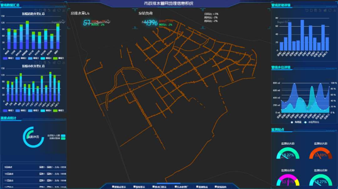
Linzhang County Pipe Network Visualization
Linzhang County Municipal Drainage Network GIS Project manages complex and valuable drainage pipe network resources in a more convenient and timely manner. The timely update and real-time maintenance of pipeline data in daily management through this system ensure the accuracy of pipeline data. It supports the dynamic management, planning and design, query and statistics, maintenance and update, analysis and optimization, flood control and drainage, and information sharing of the drainage network.
Author: Liang Zhaofei; Wu Jin; Liu Wei, Uyinfo