SuperMap iServer
Server GIS Software Platform
SuperMap iServer is a server GIS development platform built on a high-performance cross-platform GIS kernel, featuring distributed architecture and scalability. It provides full-featured GIS service publishing, management and aggregation functions, and provides multi-level expansion and development.
SuperMap iPortal
GIS Portal Software Platform
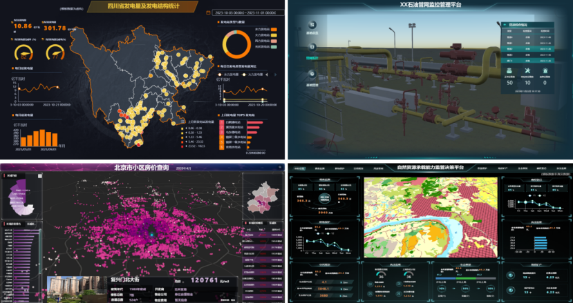
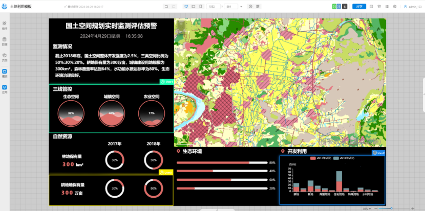
SuperMap iPortal is a GIS portal platform for integrating, searching, sharing and managing GIS resources. It has advanced technology and capabilities, such as quick website building without code, multi-source heterogeneous services registration, and multi-source service authority control, etc.
SuperMap iManager
GIS O&M Management Software Platform
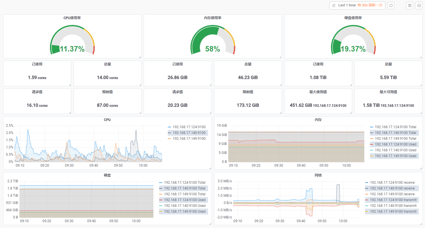
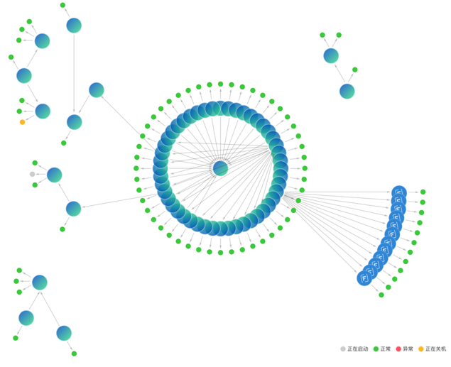
SuperMap iManager is a comprehensive GIS operation and maintenance management platform which can be used for application service management, infrastructure management, and big data management.
SuperMap Online
Online GIS Platform
SuperMap online GIS platform ( www.supermapolgb.com) integrates GIS data management, service management, data mining, and display. It helps users achieve the security of GIS data on cloud, and provides a wealth of tools for data online display and analysis, and creates a GIS resource creator platform from creation to revenue. Meanwhile, it provides multiple SDKs for developers to access, use GIS data, and quickly develop business systems.
SuperMap ImageX Enterprise
Cross-Platform Remote Sensing and GIS Integrated Server Software
SuperMap ImageX Enterprise is a cross-platform integrated remote sensing and GIS server software. Leveraging cloud-native architecture and advanced photogrammetry/remote sensing algorithms, it incorporates intelligent processing, automation, and high-performance computing technologies.
SuperMap AgentX Server (Beta)
GIS AI Agent Service Platform
SuperMap AgentX Server is a GIS intelligent agent service platform that delivers comprehensive capabilities—including intent comprehension, logical reasoning, task planning, and decision execution for complex GIS operations—through human-machine conversational interaction.

◇ Supports classic deployment modes such as single machine multi-process and multi-machine cluster, with high performance and high availability.
◇ Supports microservice architecture and docker deployment mode, with convenient deployment, fine-grained scaling, and resource saving.
◇ Provides full-featured GIS microservices such as maps, data, distributed analysis, 3D, machine learning, streaming data, etc.
◇ Supports tile publishing in Object storage such as Ali OSS, HUAWEI OBS and MinIO.
◇ Supports the use and conversion of cloud native GIS data formats and tile formats such as FlatGeobuf and PMTiles*.

◇ Provides 2D and 3D spatial data publishing, management, editing, analysis and processing.
◇ Provides domain geospatial service extension mechanism, including service capability, interface, security, cluster, etc.
◇ Supports aggregation SuperMap platform services, tripartite services, OGC services and online map services.
◇ Supports rapid publish of large-scale image (raster) data, and supports STAC-API specifications.
◇ Provides processing automation service, and supports more than 900 kinds of analysis tools including vector, grid, 3D, image, GeoAI and spatiotemporal big data.
◇ Provides OGC API service interface, and supports OGC API Features and OGC API Tiles standards.
◇ Provides knowledge graph services, supporting geospatial data querying and analysis based on graph databases, thereby enabling rapid decision-making.
◇ Supports rapid publish of camera video data, and provides capabilities for video data management, querying, and video file streaming.
◇ Supports satellite image processing service, providing automated production capabilities for optical remote sensing images such as DOM (Digital Orthophoto Map), DSM (Digital Surface Model), and DEM (Digital Elevation Model), and supports the development of integrated remote sensing GIS analysis server applications.
◇ Supports satellite image processing service, providing automated production capabilities for optical remote sensing images such as DOM (Digital Orthophoto Map), DSM (Digital Surface Model), and DEM (Digital Elevation Model), and supports building integrated remote sensing and GIS processing and analysis server applications.

◇ Supports GIS service delay initialization, and iServer starts in seconds in the case of 100,000 level stock service.
◇ Supports the active destruction of free GIS service instances to effectively reduce the occupation of system resources.
◇ Supports the control of the maximum number of online GIS service instances to improve the system availability.

◇ Supports node dynamic accessing, intelligent scaling and automatic synchronization between nodes.
◇ Supports MPP distributed relational database, distributed NoSQL database and distributed file system.
◇ Provides distributed geospatial analysis, distributed data processing, streaming data real time processing, etc.

◇ Provides distributed analysis service, and supports distributed processing and geospatial analysis of vector and raster data.
◇ Provides streaming data service, and supports real time accessing and distributed processing of streaming data with 100 thousands/sec level.

◇ Provides data publishing of 3D point, line, polygon, body, field, as well as oblique photogrammetry model, BIM and point cloud.
◇ Provides online editing capability of 3D data to edit attribute and geospatial information.
◇ Provides geospatial computing of 3D intersection, union and difference, and measurement and calculation of volume and surface area.
◇ Provides 3D geospatial analysis of sunshine, skyline, visualization, 3D buffer, etc.

◇ Provides machine learning services, and supports GeoAI analysis operator of target detection, ground object classification, object extraction, binary classification, decision tree regression, etc.
◇ Provides work flow of covering sample production, model training, model eva1uation, model reasoning, etc., and supports online interactive geospatial data scientific exploration based on Notebook.

◇ Supports GeoPDF which is printed as A0/A1 map.
◇ Supports secondary editing of geospatial/text information in printing results.
◇ Provides extensible layout template for transportation, land, etc.

◇ The "Text Block" component on the portal homepage now supports customization: custom dimensions, background colors, text colors, font types, and font sizes.
◇ Provides zero code customization, and visual operation can easily switch portal style.
◇ Provides full code customization to deeply build a dedicated GIS portal.
◇ Multiple built-in GIS function modules can be flexibly configured, and can also be deeply customized and developed to quickly respond to business needs.

◇ Now supports registering ArcGIS REST VectorTile services as service resources within the portal.
◇ Now supports batch registration of non-public SuperMap iServer services through credential binding.
◇ Now supports registering PostGIS, PostgreSQL, Oracle, SQL Server, and DM database workspaces and publishing them as services.
◇ Supports the registration and access of various OGC services, internet maps and REST services of mainstream heterogeneous GIS platforms.
◇ Supports Excel, CSV, UDB, SuperMap workspace, Shapefile, SMTiles, TPK, GeoJSON data uploading and displaying.
◇ Supports user-managed data storage for PostGIS, PostgreSQL, and MySQL databases for registered users.
◇ Supports multiple ways to retrieve GIS resources, such as fuzzy search, classification filtering, geospatial range filtering.
◇ Supports unified control of multi-source GIS Service permissions.
◇ Supports GIS resource quota and GIS resource sharing and collaboration with multiple users and terminals.

◇ Basemap configuration now supports XYZ Tile services in all coordinate systems, enhancing spatial data utilization.

◇ Now supports CAS 3.0 protocol authentication.
◇ Now enables storage of security information and session data in GaussDB databases.

It is a lightweight and high-efficient data visualization application, providing thematic map making, streaming data visualization and map printing, which can realize Web map making and sharing.
◇ Supports adding OGC WMTS, OGC WMS, and ArcGIS REST VectorTile services through search.
◇ Supports adding XYZ Tiles layers, ArcGIS REST VectorTile services, and third-party Mapbox vector tile services via web.

It is a GIS application running on the Web. It provides rich GIS capabilities. It is used for rapid mapping, spatial analysis, and spatial data editing on the Web. At the same time, based on vector tile rendering technology, it provides a smooth map browsing experience.
◇ New AI mapping functionality supports intelligently generating professional maps through natural language interaction, allowing modification of layer styles, layouts, animation effects, and democratizing map creation.
◇ Now supports adding ArcGIS REST VectorTile services and XYZ Tile services via URL.
◇ New custom web symbol configuration capability supports defining web symbols using JPG and PNG images.
◇ New feature snapping functionality enables snapping to existing layer features or features being drawn.
◇ New data export functionality supports exporting data to CSV, GeoJSON, and JSON formats.
◇ Feature editing now supports splitting/merging features and deleting vertices using shortcut keys.
◇ Supports configuring layer styles with 2D/3D and animated visualization effects.
◇ Supports templates for point layers, line layers, polygon layers, composite symbols, heatmaps, and clustering maps.
◇ Provides processing tools including grid-based aggregation, zonal summarization, and overlay analysis to unlock the value of spatial information.
◇ Supports adding OGC WMTS, OGC WMS, and ArcGIS REST VectorTile services through search.

Natural Language Interactive Professional Map Generation

Rich Layer Visualization Effects

It is a geospatial data analysis Web application. It can realize online visualization and analysis of geospatial data through interactive operation. It integrates SuperMap iServer distributed analysis and data science service, and supports extension to help users dig the value of geospatial data.

It is a Geological data visualization dashboard application. It can display the location analysis in the way of intuitive and interactive visualization, which can help decision making, visualization trend analysis, real-time monitoring and spatio-temporal playback analysis.
◇ Enhances multi-user real-time collaborative editing capabilities, and enables real-time synchronization of other users' modifications to map and scene content.
◇ Supports saving dashboards as new deliverables during collaborative editing sessions.
◇ Scene components now feature linked interaction capabilities for synchronized displays between scenes and scene-to-map.
◇ New support for Tianditu (China's official basemap) as scene basemap, enhancing visualization quality.
◇ Scene components now include layer list subcomponents for managing layer visibility and ordering.
◇ Map components now support selecting registered SuperMap iServer map services from resource center.
◇ Component configuration now allows controlling map zoom levels for precise view transitions.
◇ Indicators, progress bars, liquid fill gauges, dashboards, and text components now support numeric field statistics.
◇ Value labels in chart components, legends, and progress bars now support decimal place configuration.
◇ New hyperlink field configuration capability for text in list components.
◇ Supports map and scene switching between different pages, facilitating multi-perspective map and scene displays.

Provides Multiple Industry Application Templates

Real-Time Collaborative Editing for Multiple Users

It is a processing automation web application that quickly builds business process models, and helps realize automate complex data processing and analysis processes.
◇ Now supports publishing and exporting model libraries.
◇ Now supports directly using MySQL database data in modeling via drag-and-drop.
◇ Supports customizable UI styles and custom operator parameter configuration UI.
◇ Supports data resource directory where users can drag data nodes into modeling workflows as variables.

It is a full-featured 3D WebApp developed using SuperMap iClient3D for WebGL, offering plugin-free and excellent compatibility features. It provides efficient loading and management of heterogeneous 3D data from multiple sources, enabling rapid construction of 3D visualization scenes. Users can browse, query, analyze, and share scenes online seamlessly.
◇ Provides multiple public services, online base maps, and online terrain for quickly building 3D scenes.
◇ Custom services now support loading MVT data and ArcGIS REST services, enabling keyword-based searches for corresponding WMTS services.
◇ Data loaded via My Services now supports service-type/keyword-based searches, allows adding MVT layers from data services to scenes, and adding imagery from map services to scenes.
◇ Direct attribute queries now supported for S3M 3.0 to 3.01 data versions.
◇ Attribute queries for S3M 1.0 to 3.01 tiles loaded through data services now support automatically pass data sources and datasets.
◇ Optimized oblique monobuilding queries now support adding videos, images, PDF d0cuments, or hyperlinks to result attribute panels as annotations.
◇ Supports loading terrain, imagery, oblique photography, 3D models, point clouds, BIM, city detailed models, architectural wireframe data, point/line/area, and other heterogeneous spatial data sources.
◇ Provides extensive 3D analysis, querying, and measurement functionalities, including line of sight analysis, distance/height/area measurements in multiple measurement modes, and oblique monomer queries.
◇ Supports adjusting scene properties such as shadows, brightness, enabling underground views, and newly added capability to save and reopen pre-configured scene properties, facilitating quick restoration of scene visualization effects.
◇ Provides 3D special effects including lighting, scene ambient lighting, rain and snow effects, enhancing scene realism.
◇ Provides functions such as split-screen, curtain effect, and video projection to achieve scene interaction and management.

It is a lightweight 3D WebApp developed based on SuperMap iClient3D for WebGL, with online rapid modeling and multiplayer interactive editing capabilities based on real geographic environments, empowering industries such as urban design and digital transportation.
◇ Supports loading of online terrain data, image data, oblique photogrammetric 3D model data for constructing scene basemaps.
◇ Supports loading online vector data for modeling, with added support for loading data in GeoJSON format.
◇ Supports rapid batch construction of 3D models such as buildings, roads, pipelines, tunnels, and ditches based on vector data and modeling rules.
◇ Supports model material editing, model parameter editing, style settings, and allows real-time updating of editing and setting results.
◇ Provides project management capabilities, including automatic saving, sharing, downloading, viewing, and re-editing of modeling results. Newly supports permission settings and service configuration.
◇ Provides a material editor supporting online creation, renaming, deletion, editing, and sharing of standard materials and PBR materials.
◇ Provides scene auxiliary operation tools, including view switching, selection editing, and distance/height/area measurements.
◇ Provides scene editing and browsing tools, including tilt operations, adding model objects, annotation plotting, scene roaming, and viewpoint management.
◇ Provides scene effect adjustment capabilities, supporting settings for scene properties such as sun position, as well as parameters for rainy, snowy, and skybox conditions.

The Modeling Results Support PBR Materials, Enabling More Realistic Representation of Buildings

Supports Sunlight Analysis with Analysis Results Conforming to Model Surface Display

SuperMap iPortal AI Assistant is an AI-powered application built on SuperMap AgentX Server, revolutionizing GIS interaction by replacing complex menus and graphical interfaces with intuitive, low-barrier Q&A-style engagement. Through natural language requests, it accurately identifies task commands, autonomously invokes corresponding spatial intelligence tools to execute complex operations, delivering a transformative smart interaction experience.
◇ Supports user management capabilities with conversational invocation of tools for user deletion, resource quantity queries, and user resource migration.
◇ Enables resource management capabilities via conversational tools for frequently accessed resource queries, user login status checks, resource search, resource data inspection, service publishing, statistical analysis, and chart generation.
◇ Provides map visualization capabilities through conversational tools for basic mapping, heatmaps, thematic maps (single-value/segmented), 3D column/heat maps, aggregated maps, statistical maps, layer overlays, and Origin-Destination (OD) mapping.
◇ Supports proximity analysis capabilities using conversational tools for numeric/field-based buffering, proximity summarization, distance calculation, proximity queries, and geometric object proximity analysis.
◇ Supports data summarization via conversational tools for spatial summarization, field/zonal/grid summarization, structured dataset attribute analysis, regular/spatiotemporal grid analysis, nearest-distance multivariate network/grid analysis, and intersecting feature summarization.
◇ Supports spatial overlay capabilities with conversational tools for overlay analysis, multi-layer overlays, and spatial joins.
◇ Supports machine learning capabilities through conversational tools including density-based clustering analysis.
◇ Provides data processing capabilities via conversational tools for convex hull calculation, geometric clipping (single/multi-object), column appending, dataset merging, topology validation, data appending, and field calculations.
◇ Supports pattern analysis capabilities using conversational tools for OD matrix creation, density analysis, hotspot detection, hotspot grid identification, and similar location screening.
◇ Supports remote sensing analysis through conversational tools for image collection retrieva1, binary classification, change detection, object extraction, feature classification, and target detection.
◇ Provides 3D analysis capabilities via conversational tools for viewshed, skyline, and line-of-sight analysis.
◇ Enables data conversion capabilities with conversational tools for format transformation.
◇ Supports geocoding capabilities through conversational geocoding tools.
◇ New Agentic RAG capability integrates knowledge base retrieva1 with tool invocation.
◇ New GraphRAG capability embeds GI tool knowledge graphs within geospatial agents for reliable task recommendations.
◇ New compatibility with mainstream open-source models and cloud-based LLM services supports flexible configuration.
◇ New MCP protocol standardizes geospatial agent tool interfaces and enables internal/external tool integration and collaborative invocation.

Natural Language-Based 3D Viewshed Analysis

◇ Supports visual deployment methods to lower deployment barriers, facilitating easy and efficient setup.
◇ Provides one-click deployment of GIS systems and big data sites.
◇ Provides rapid creation of spatial data science environment and spatial blockchain environment.
◇ Provides a one-click deployment computing environment: Spark cluster, Hadoop YARN cluster.
◇ Provides a one-click deployment storage environment: HBase, PostGIS, PostgreSQL, HDFS, MySQL, Redis, Elasticsearch, MinIO, etc.
◇ Provides a one-click deployment steam data environment: Kafka cluster.
◇ Provides UI customization, and supports the deployment and management of third-party industry applications.

◇ Provides JVM monitoring for hardware resource occupancy, usage of various service resources, and GIS cloud suite service nodes.
◇ Provides intelligent alarm.
◇ Provides alarm rule management of general monitoring and database monitoring.
◇ Provides statistical report.
◇ Provides service topology map of GIS site.
◇ Provides service CPU adjustment and memory specification.
◇ Provides capability of GIS site resource restriction.
◇ Supports one click switching of site access addresses and protocols, and supports configuring dual protocols for GIS cloud suite sites simultaneously.
◇ Supports site storage expanding, and supports multiple storage for the site.

◇ Provides GIS microservice monitoring, elastic scaling and error recovery.
◇ Supports rolling update of designated service.
◇ Provides capability of GIS cloud site backup and recovery.
◇ Integrated service grid technology supports gray publishing, access control, service measurement, and service tracking.
◇ Supports GIS cloud spatial analysis tasks, geographic processing automation tasks, distributed tile cutting tasks and 2D/3D tile distribution tasks to run in a serverless GIS function manner, ensuring greater stability, flexibility, and efficiency.
◇ Supports automatic detection of instance status and automatic repair of alarms and anomalies in GIS cloud suite services, reducing operation and maintenance costs.

SuperMap iManager Hardware Resources Monitoring

Topology Map of GIS Site Microservice

◇ Provides account management system, supporting personal and corporate authentication, providing a safer and more convenient management experience.
◇ Provides unified management for account quotas, purchasing services, licenses, revenue, and messages on personal or corporate console.

◇ Storage and use: safety on cloud of 2D/3D data (SuperMap workspace, UDB, Excel, Shapefile, GeoJSON, etc), and can be browsed, queried, edited, analyzed through cloud application.
◇ Mobile office: download and share data through Web, PC and mobile terminals anywhere at any time.
◇ Easy maintenance: with its own GIS cluster, health monitoring and self-recovery capabilities, users do not need to care about deployment and operation and maintenance.

GIS Cloud Storage Helps Data on Cloud Security

◇ Provides GIS cloud server module for renting, reducing one-time investment costs, and flexibly responding to business needs.
◇ The published GIS services can be directly accessed on the public network without paying attention to network issues.
◇ Supports one click publishing service, and supports common GIS data files such as SuperMap workspace and Shapefiles to be published as standard OGC.
◇ Supports quick immigration of local services to the cloud by guided tools.
◇ Supports convenient setting of service access permissions and multiple service monitoring tools.

◇ Various Web Apps: DataViz WebApp, DataInsights WebApp, Earth WebApp, map matching, MapDashboard WebApp, map studio, etc.
◇ Supports online interactive visualization and 2D and 3D data analysis to output results conveniently and share online in multiple ways.
◇ Lightweight online GIS gadgets to quickly complete common GIS analysis and processing tasks.
◇ Online experiences remote sensing image AI analysis and real 3D China in solution module.

◇ It is a GIS resource platform focused on the creator, providing functions such as resource creation, listing, and transaction, and it reflects the whole process from creation to revenue, and experiences a different GISer online creation community.
◇ Provides a variety of selected, self-operated, and third-party resources for free use, including excellent resources like massive thematic data and services, large-screen templates adapted to various industries.
◇ In addition to traditional GIS resources, it also provides material resources (drawing symbols, color schemes, etc.) and extension resources (plugins, demonstration programs, d0cuments, etc.) for producing GIS results.

GIS Resource Creator Platform

◇ Cloud Service Personal Edition is designed specifically for individual users to manage and publish GIS data online, and create amazing online maps and applications.
◇ Cloud Service Government Enterprise Edition is specially customized for government and enterprise users, with comprehensive member and permission management solutions to better manage enterprise resources and quotas.
◇ Desktop users, web developers, component developers, and mobile developers can purchase, authorize, and manage licenses online.
◇ Cloud service expansion package provides multiple quota enhancement capabilities, and more flexible use when paired with packages.

◇ JavaScript development: Supports quick creation of online web applications based on SuperMap Online data hosting, map visualization, data analysis by API or SDK in web scenes.
◇ Android/iOS development: Provides quick creation of mobile applications based on SuperMap Online data hosting, map visualization, data analysis, path navigation, forward and inverse geocode, local search by Android/iOS SDK.
◇ Web service: Provides cloud analysis such as path navigation, forward and inverse geocode, coordinate conversion, local search, plotting services in the form of standard REST API to be integrated into different language environments such as JavaScript, C #, C++, Java, Python to use online GIS capabilities.
◇ Rich development examples and d0cument support: demos for data processing, map services, online applications, and detailed development d0cuments to help developers get started.

GIS Development Center Helps the Rapid Development of Business Systems

◇ Distributed High-Performance Computing: Supports distributed and cloud-native technologies. Based on Serverless architecture, the Image GeoFaaS service provides high-performance processing for large-scale image production.
◇ Provides process-oriented workflows and task-specific tools to meet diverse production requirements.
◇ Supports scheduled tasks for automated unattended operations at preset intervals.
◇ Enables task management with task list filtering, detailed task views, and log inspection.
◇ Supports multi-granularity image production workflows (DOM generation, image fusion, color balancing) for optimal automated processing.
◇ Allows template-based parameter configuration for reusable preset templates.

◇ Supports block adjustment for large-scale imagery using linear/quadratic/cubic polynomial RPC correction models.
◇ Supports batch orthorectification of optical satellite imagery with zonal output capabilities.
◇ Supports fusion algorithms (Gram-Schmidt, Pansharp) with precise parameter control for optimal multispectral color fidelity.
◇ Supports true-color fused outputs with synchronized bit-depth reduction, band reordering, and enhanced vegetation rendering.
◇ Provides multiple color balancing methods (dodging, color mapping, adaptive) for diverse scenarios.
◇ Automatically generates seamlines avoiding buildings/clouds while optimizing along linear features (roads, rivers).
◇ Supports mosaic output modes: full-scene, vector-clipped, standard tiling, and single-scene export.

◇ Supports image planimetric accuracy assessment with auto-generated checkpoints and check polygons for rapid eva1uation of positional and edge-matching accuracy.
◇ Supports detailed planimetric accuracy assessment through tiled quality inspection within specified regions, facilitating error distribution analysis across sub-areas.
◇ Provides ghosting detection capabilities (mountain/road/building ghosting) for rapid deformation localization and streamlined manual verification workflows.

◇ Supports image export tools enabling batch format conversion, band combination adjustment, and reprojection operations.
◇ Supports image resampling tools to reprocess spatial resolution of imagery data.
◇ Supports bit-depth conversion tools for depth adjustment and display stretching.
◇ Supports image pyramid tools for batch creation and deletion of pyramids.

◇ Supports binary classification and intelligent land cover classification model inference.

◇ Supports processing of common satellite remote sensing data including GF-1/2/6/7, ZY-1 02C/02D/02E, ZY-3 01/02/03, BJ-2/3A/3N, JiLin-1 series, IKONOS, WorldView series, SPOT5, Pleiades-1, SuperView-1, and SuperView Neo-1.
◇ Provides native support for common raster formats (*.tif, *.tiff, *.img, .pix, .jp2) eliminating format conversion requirements.
◇ Supports input/output operations via file directories or imagery services.

◇ Supports rapid publishing of remote sensing imagery as web-viewable imagery services.
◇ Supports dynamic band order adjustment for custom spectral combinations.
◇ Provides a map swipe tool for comparing differences between overlapping images.

◇ Supports user management with administrator and regular user types.
◇ Provides comprehensive logging output throughout task execution, including Pod, UGO, and task information.
◇ Supports image resampling tools to reprocess spatial resolution of imagery data.

◇ Supports Windows non-cloud-native environments.

◇ Integrates with leading open-source models (Baichuan, ChatGLM, Qwen, DeepSeek) and cloud-based LLM services (Tongyi Qianwen, ERNIE Bot, OpenAI).

◇ New Model Context Protocol (MCP) standardizes geospatial agent tool interfaces, enabling collaborative invocation of internal/external tools.

◇ Provides multi-agent service modes like Chatflow Agent (Q&A-based), Workflow Agent (process-driven), and Autonomous Agent (self-planning).
◇ Features built-in SuperMap industry knowledge base with custom knowledge base support for domain-specific tool invocation.