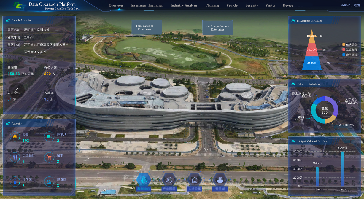
Poyang Lake Eco-Tech Park, with a total planned area of 158.53 square kilometers, is an innovation center of the local city. The informatization of geospatial data is of great significance for promoting the economic development of the park. A GIS service platform is developed aimed at providing a basis for other platforms and applications in the informatization project of this zone.
SuperMap and AsiaInfo build a geospatial database by integrating geospatial data of the whole region and each topic and relying on geographic information, cloud computing, big data, IoT, etc. A GIS engine is formed to provide GIS data and functional services for operation platforms and applications such as smart parking and promote the integration and sharing of information across the region.
The GIS service platform provides unified standard GIS services for other platforms and application systems in this project. The platform requirements mainly focus on:
Geospatial database
A geospatial database encompassing residential areas, industrial and mining buildings, transportation, pipelines, water systems, boundaries, landforms, soil and vegetation and geospatial images, three-dimensional landscape, and expanded from previous geographic information results such as housing, traffic, urban management by the Municipal Bureau of Natural Resources will be formed. It should include basic terrain, Hi-fi images, and 3D building models.
GIS platform
Geospatial information services can be provided for each application system in the comprehensive management platform of the zone. By registering GIS application services to the service bus, it provides the underlying support capabilities and unified services for the invocation of spatial technology-related functions of the upper-layer application systems.
Construction
Geospatial database
According to the project construction requirements, the database design and specification of the corresponding basic data are formulated. The platform should be responsible for the storage, performance tuning, and software integration of the result data, to ensure that the data results meet the project software application requirements.
GIS engine
According to the project requirements, the GIS software provided includes:
Service GIS software for GIS platform geographic information service release and application demonstration geographic information release;
Portal GIS software for integration, search, sharing, and management of GIS resources;
Desktop GIS software for data management, data processing and type conversion, 2D and 3D object drawing and editing, thematic map production, 3D scene rendering, etc.;
Managed GIS software for GIS platform background operation and maintenance management.