Chaohu Lake is one of the five largest freshwater lakes in China. The water area is 779.51 square kilometers. Chaohu Lake is rich in products. It plays an important role in agricultural irrigation, promoting inner lake water transport, maintaining ecological balance and promoting regional development.

The “Digital Chaohu” platform is built on the basis of SuperMap GIS, using multi technologies such as 2D-3D integrated GIS, spatio-temporal big data, remote sensing image analysis, and drone aerial photography. With departmental data sharing as the core, it establishes and improves the air-space-ground integrated monitoring system, builds a space-time integrated big data platform, develops a multi-purpose numerical model, and a multi-functional application system. It initially supports grasping the status quo and trend research and judgment of water safety and water environment, forecast and early warning, provides support for flood control and drought relief, environmental protection, ecological restoration, comprehensive dispatch, cyanobacteria prevention and control, daily supervision, etc., and also provides experience and reference for comprehensive management of water environment in various river basins.
The platform is built according to the method of “one network, one map, one center, three systems and N applications”.
“One network” refers to the establishment of an integrated space-air-ground monitoring network in the Chaohu Lake Basin;
“One map” refers to the use of geographic information system technology as the basic framework to integrate data from multiple departments such as river basin geography and national conditions, meteorology and hydrology, water conservancy engineering, environmental ecology, etc., to manage lakes with maps, and realize comprehensive management of river basins with one map;
“One center” refers to the construction of a cloud data center, including computing, storage, network and other hardware resources and system software resources;
“Three systems” refer to the standard system, operation and maintenance system, and security system;
“N application” refers to the design and development of several application modules based on one map: including water quality, water quantity, total pollutants, cyanobacteria bloom monitoring, early warning and forecasting, grid-based management of non-point sources in rural watersheds, lake (river) chief system management, primary protected area management.
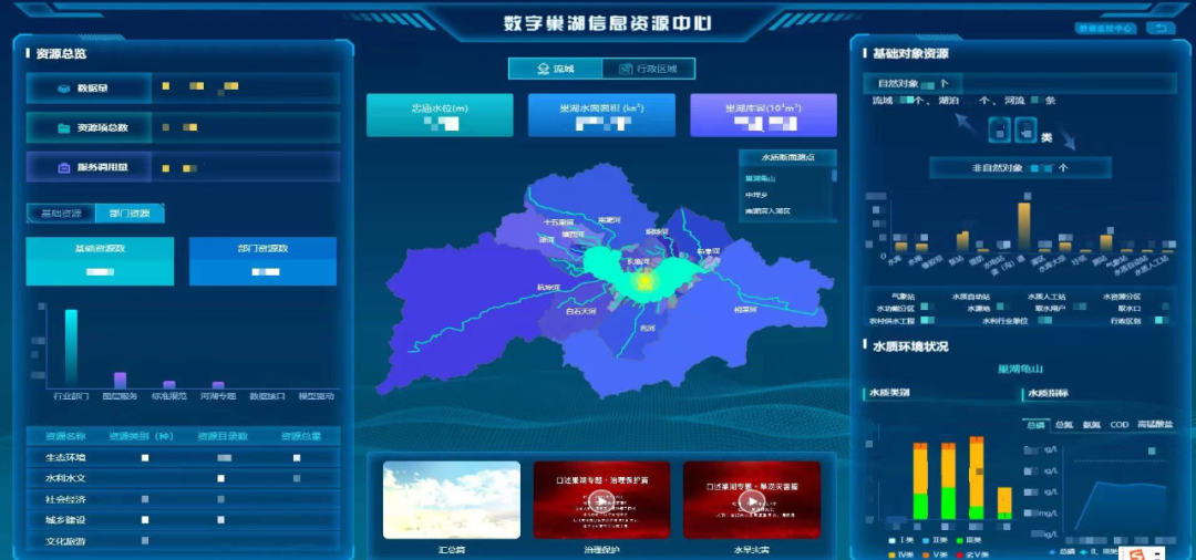
The platform integrates the 2D and 3D data of the Chaohu Lake Basin and the monitoring data of various departments. 2D and 3D data such as new watershed terrain, oblique photography of the first-level protected area, 3D model of the seven gates and one station, and 3D lake basin, take a total of 1.8TB. In order to integrate resources and save investment, it achieves the data sharing of meteorology and hydrology, ecological environment, urban and rural construction, geographical conditions, population economy, water conservancy projects, etc., and collects historical and dynamic monitoring data of hydrology, water quality, and meteorology. As of August 24, 2022, a total of 255 million pieces of data have been accessed.
The project uses several geographic information technologies, innovates the business management model based on “one map’, and strives to create a “temporal and spatial big data base” for the Chaohu Lake Basin.
Technical features
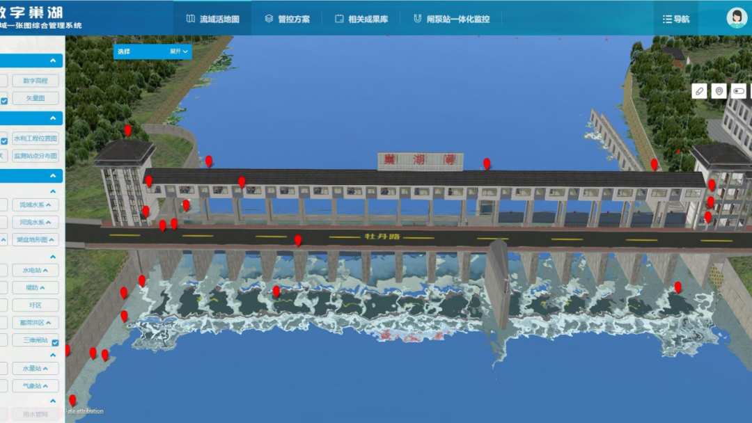
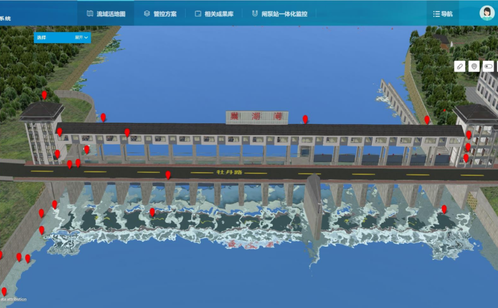
1. Through the compatibility of the data format of the SuperMap GIS platform, the project integrates Chaohu Lake Basin vector, image, terrain, 3D (oblique photography, artificial fine model, lake basin 3D) and other 2D and 3D data, and optimizes and processes them into standard spatial 3D data format, build a three-dimensional digital twin base of the Chaohu Lake Basin, and support the visualization and fine-grained management of the watershed.
2. The project organically combines cross-platform GIS technology and micro-service GIS technology, which greatly improves the application performance of spatial geographic information results and reduces the difficulty and cost of system maintenance.
Operation innovation
1. The project realizes the integrated management of meteorological and hydrological, ecological environment, geographical conditions, hydraulic engineering and other spatial data, attribute information, relationship and metadata, unify object coding and data dictionary, and finds out and establishes the “data family background” of Chaohu Lake Basin. On this basis, a practical numerical prediction model has been developed, including a water quality and water quantity coupling model, a cyanobacteria bloom monitoring and early warning model, and an auxiliary support system for river basin flood control, which have played a supporting role in flood control and drought relief, environmental protection, ecological restoration, and comprehensive scheduling.
2. The project fully integrates the data of various departments such as meteorology and hydrology in the basin, and realizes the realistic simulation, efficient visualization and three-dimensional space analysis of the geographic elements of the basin. It establishes an integrated monitoring system for the water environment of the watershed, which can intelligently diagnose and automatically alarm the abnormal information of the water environment in the watershed, build a spatio-temporal data model and intelligent analysis algorithm for the multi-source water environment monitoring data in the watershed, and quickly perceive the current distribution, change trend and status of the water environment. It integrates a complete set of mechanism models for the precise reduction of pollutants in the watershed, and proposes an optimized emission reduction plan for the watershed pollutants under the constraints of the water quality goals of the watershed.
3. The project uses satellite remote sensing, unmanned aerial vehicles, video surveillance, meteorological monitoring, hydrological monitoring, water quality monitoring and other means to build a “space-air-ground” 3D monitoring network, and develop numerical simulation and empirical simulation applications of cyanobacteria blooms. It supports grasping the condition of cyanobacterial blooms in Chaohu Lake at three levels: the entire lake area - key areas - key locations, with the help of short-term (the next two days, hourly) and long-term (the next week, day-by-day) forecasts, provide support for the scientific prevention and control of cyanobacteria.