Forests play a special role in reducing various natural disasters. The quantity and quality of forest resources not only affect the economic development of a country or a region, but also the ecological development and human survival.
In order to better implement the Korean forest planning, the Korean Forestry Bureau and SuperMap has created a GIS forest disaster management system based on various forest databases (including forest maps and national forest resources surveys).
Construction Objects
The main objects of the system are: first, it protects forest resources, protects and improves forest ecosystem. Second, it predicts forest disaster information related to the forest spatial information. Third, it prevents forest disasters, and reduces identification time of disasters. Fourth, it connects with various government agencies and information to manage fires, landslides, pests and forest ecosystems, so as to improve the efficiency of rescue operations and minimize the deaths and property losses in forest disasters. Fifth, it provides space location information and quick response services for on-site rescue.
System Requirements
-Data Processing
The project involves a large number of different types and formats of data, including basic vector data, remote sensing image data, text data, and some intermediate results data. These data usually have various quality problems that need to be extensively collected and classified before using. Also, the necessary processing actions should be performed on data according to system construction requirements, such as image data correction, splicing, etc. Therefore, the data collection, classification, pre-processing, warehousing and so on should be carried out before the system construction, which can provide data guarantees for system construction.
-Database Building
After the preparation work of data collection and processing, the database structure needs to be designed. A good database structure can guarantee the efficiency and performance of the system and avoid unnecessary redundancy.
Therefore, the database construction and qualified data inputting is the premise of system construction and the guarantee of good operations. The system established a forest disaster database that includes forest space information and forest ecosystem information.
-Subsystem Construction
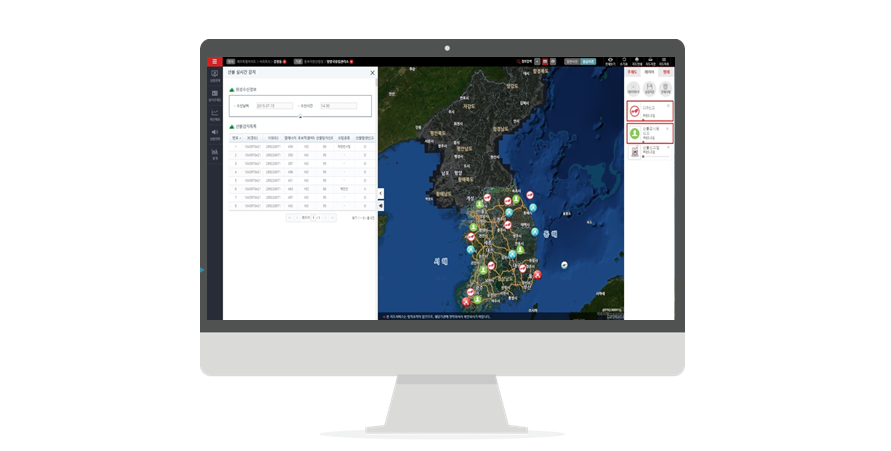
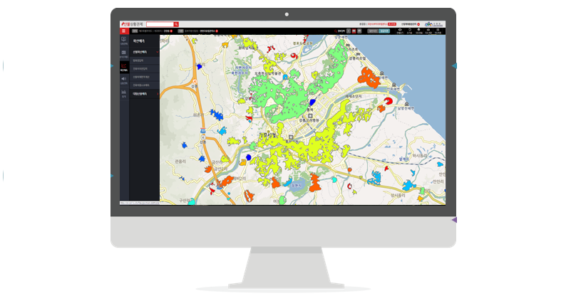
Based on the forest disaster database, the forest information sharing platform and forest information sharing portal are established for the sharing of forestry information and forest thematic maps. According to the business requirements of Korean Forestry Bureau, the forest disaster database management system, forest fire management system, forest pest management system, and landslide management system were established. Among them, the database management system is used to store and manage various types of forest disaster monitoring data and related geospatial data. The forest fire management system is used to manage fire monitoring, fire spreading, fire fighting and afterwards management. The forest pest management system is used for forest pests management includes forecasting, epidemic investigation, disaster prevention planning implementation and analysis. The landslide management system is used for landslide detection, forecasting, management, prevention planning implementation and disaster afterwards management.
System Function Design
Forest Fire Management System
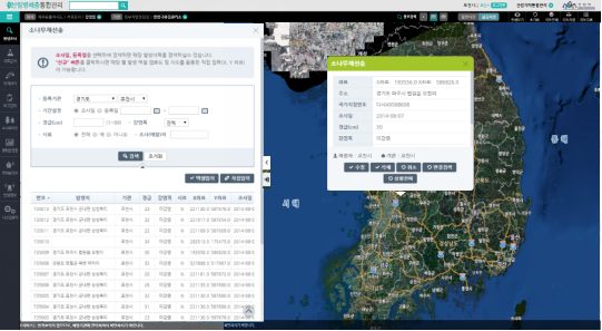
The forest fire management system provides the functions such as disaster rescue information inquiry, forest fire monitoring, COMS automatic detection, disaster response, and disaster warning. The disaster rescue information inquiry function enables people to inquire the disaster rescue information of the place where wildfire occurs. The forest fire monitoring function provides wildfire monitoring, which can be divided into the individual report and system report. The individual report can report fire cases through the 119 public reporting system and forest guard activities. And the system report can monitor wildfire through the COMS and the closed circuit television. The COMS automatic detection function refers to the development and application of the wildfire detection algorithm. It not only automatically monitors Korea, but also monitors Southeast Asia, which can be effectively used to monitor the fires at nighttime.
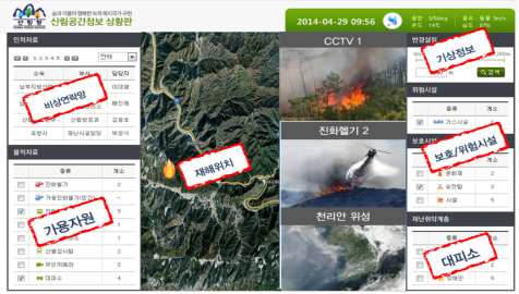
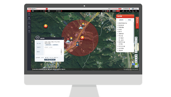
The rapid response function of disasters refers to the possibility of conducting the space survey when a disaster occurs. For instance, the confirmation of the infrastructure of the country within 1-2 km from the origin of a fire can help to minimize the loss of life and property. When a disaster occurs, it can send the text messages to nearby fire fighters with mobile phones and display the location and movement path of wild fires, so that fire fighters can quickly understand the fire status. The disaster warning function can predict the occurrence of wild fires and confirm the location where forest fires are prone to occur through the classification of wild fire risks.
Forest Pest Management System
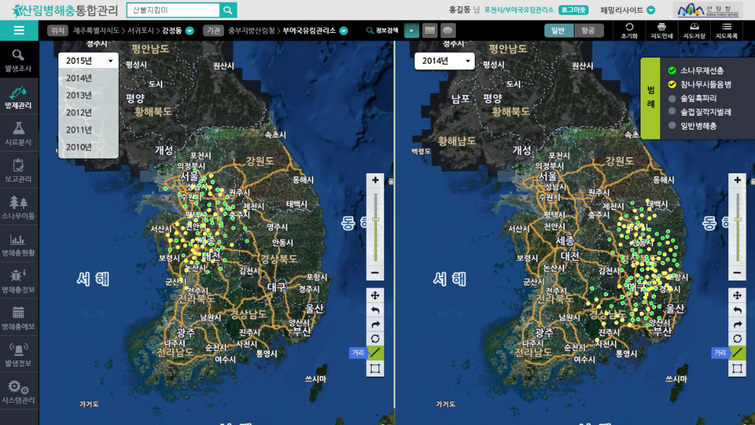
The forest pest management system provides the functions of forest pest information sharing, forest pest forecasting, and forest pest disaster time-series simulation. The forest pest information sharing function can help to minimize damages by sharing and using information of forest disaster, pests disaster and disaster prevention. It can spread information to nearby areas of forest disasters and pest disasters, and provide disaster prevention resources and cases. The forest pest disaster forecasting function refers to automatically inputting forest disaster and pest survey data through excel and sharing in real time to reduce the management work. The system can also share the information with nearby governments to prevent the spread of forest diseases and pests. The time-series simulation function of forest pests disaster can conduct time-series analysis on the development of forest pests disaster, and develop basic information for planning and conducting basic research on forest pests disaster.
Mountain Landslide Management System
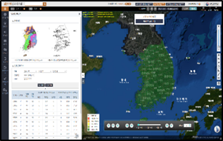
The landslide forecasting system integrates the information of regional rainfall distribution and geological features in Korea for landslide prediction.
The Korean Forest Disaster Management System enables the minimization of death and property damage, protects forest resources, and improves the forest ecosystems. It has completely changed the traditional working methods, shortened the forest disaster processing time and the identification time of forest disasters and pest disasters, and improved the accuracy of fire forecasting and landslide forecasting. In all, the system greatly improves the economic benefits of the Korean government in forest disaster prevention and relief.