SuperMap's meteorological industry solutions cover meteorological data processing, display, analysis and meteorological and climate services. The main platforms include:
Disaster risk survey system and disaster risk management system involving the whole process of disaster investigation, visual query, display and analysis of multi-source disaster data, disaster assessment, risk early warning, disaster relief and emergency response;
Refined agricultural meteorological service platform based on "Internet Plus".
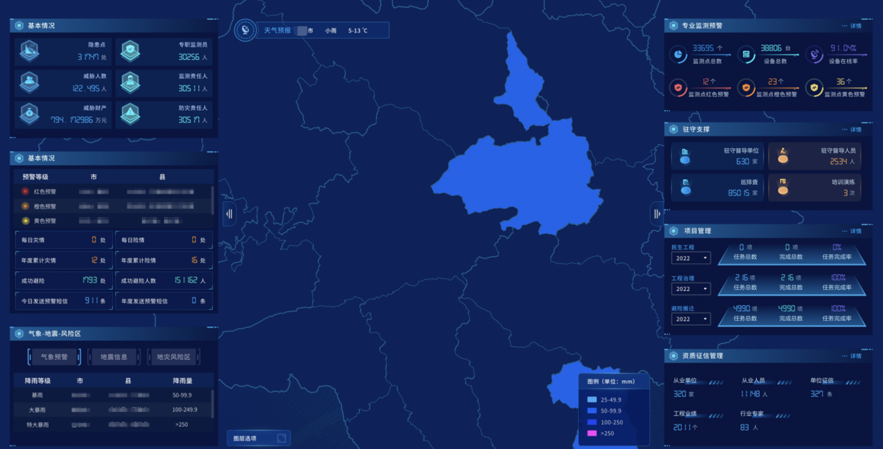
Meteorological Disaster Risk Management System
The system gathers disaster data, industry data, Internet data and other multi-channel meteorological disaster data; meteorological observation, forecast, disaster process, inundation data and other disaster factors, hidden danger points, early warning points, population, GDP and other carrier information to form a meteorological disaster risk large database, enabling more than 100 kinds of professional model algorithms.
The platform supports the automatic monitoring and identification, early warning, assessment, risk zoning and interactive production and service of various meteorological disasters such as rainstorms, floods, droughts, typhoons, high temperatures, and low temperature freezes.
The system provides the whole process of disaster risk product and service, and can be used as a data platform, operation platform and research platform to provide support for meteorological disaster risk management and natural disaster defense.
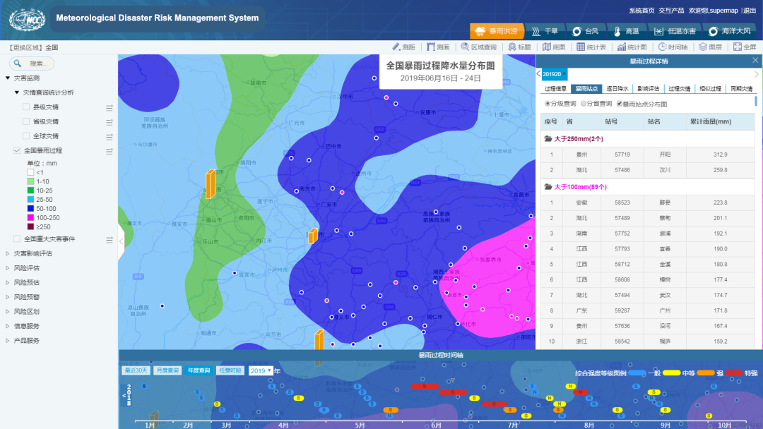
Disaster process recognition
Meteorological Disaster Risk Survey System
The Meteorological Disaster Risk Survey Platform comprehensively acquires information on various meteorological disaster-causing factors, disaster-forming environments and carriers, and carries out a risk assessment and zoning of disaster-causing factors; at the same time, it supports comprehensive risk assessment and zoning of multiple hazards and factors. It is a valuable platform for users to objectively understand and evaluate the disaster risk level of major meteorological disasters, and provide data, technology and platform support for meteorological disaster risk surveys, risk assessment and risk zoning.
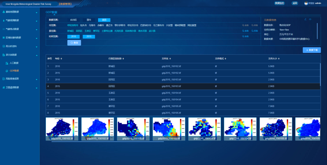
Data management
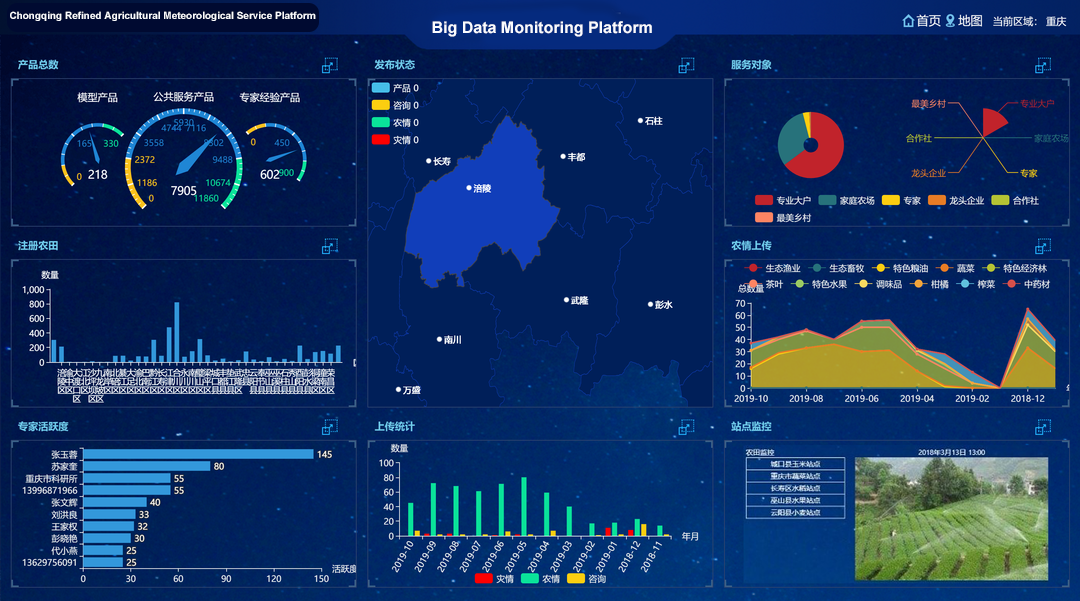
Refined Agricultural Meteorological Service Platform
Based on big data, Internet of Things and multi-source spatial information integration technology, the platform built a comprehensive operation service system featuring the integration of agricultural meteorological disaster prediction and early warning, monitoring and diagnosis, risk analysis, disaster assessment and technical services.
It supports automatic big data aggregation processing, full-cycle progress monitoring, comprehensive research and judgment of all-element maps, and multi-channel refined services for major agricultural meteorological disasters from pre-disaster risk analysis and early warning assessment, disaster tracking and monitoring diagnosis to post-disaster intensity analysis and loss assessment.
Agricultural meteorological monitoring platform