In the investigation of geological disasters, it is necessary to keep an eye on the "old problems" and find out the "new hidden dangers" generated by the development. "Where are the hidden dangers of earth disasters?" "When will it happen?" have always been the two core issues of earthquake prevention and control. Solving the "when will it happen" earthquake prediction has been hailed as a "world-class" problem.
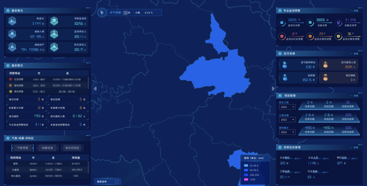
Relying on the geological disaster environmental information management platform and supported by the SuperMap GIS platform, Sichuan Province has built a multi-source stereoscopic observation system based on spaceborne+UAV photogrammetry+ground platform and developed and constructed the Sichuan provincial geological disaster situation visualization hidden danger identification system (hereinafter referred to as "system").
The system can carry out early identification and early discovery of major geological disasters' hidden dangers. Through professional monitoring, it can also carry out real-time early warning and forecast of geological disasters based on mastering the dynamic development laws and characteristics of geological disasters, and solving the problem of "what are the hidden dangers and where are they?"
Multi-source heterogeneous data free-slicing release
Provide technical support for disaster monitoring and early warning
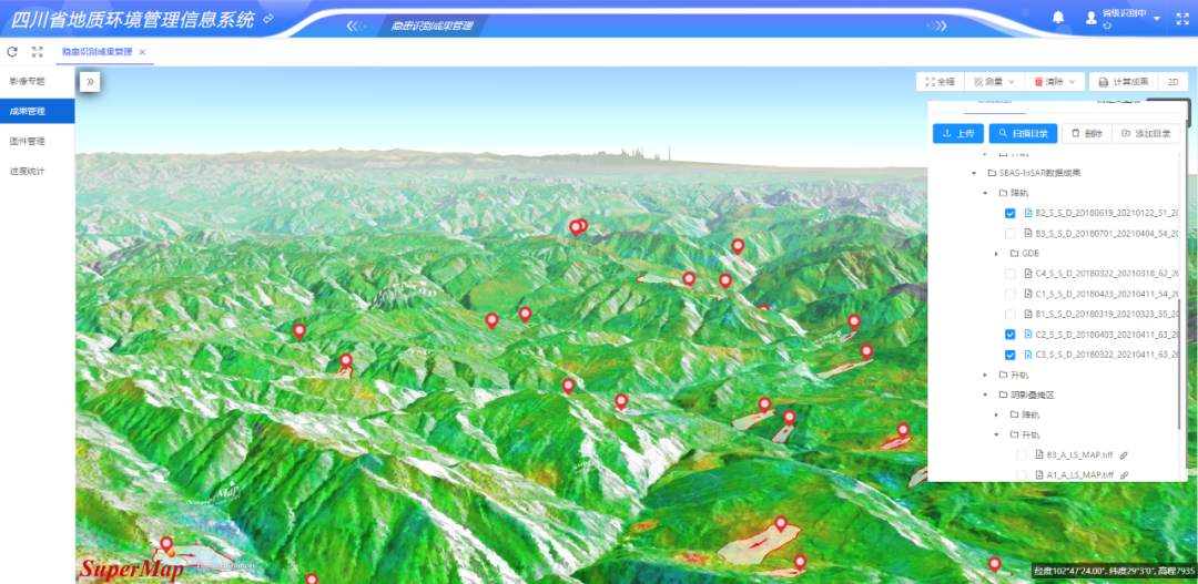
By integrating remote sensing big data, InSAR deformation data, UAV photogrammetry, disaster background data, disaster hidden danger data, and other 2D and 3D data resources, the system supports the service release, management, and aggregation of multi-source data to form a comprehensive information platform integrating online visual analysis, display, monitoring, and emergency technical support.
Through technologies such as distributed storage, vector pyramid, distributed rendering, automatic caching, and front-end progressive loading, the platform realizes the "slicing-free" release of data, which solves the problem that traditional slicing methods cannot be updated and released on time.
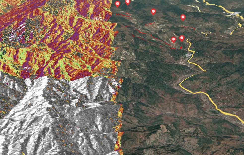
▲ Multi-source remote sensing data
Technology “eyes” + “smart” brain
A whole picture of hidden dangers
The system adopts the SuperMap GIS 2D&3D integrated technology to realize the high-performance visualization of massive 2D data directly in the 3D scene, the superposition and comparison of multiple types of information in geographical space, and the access of multi-channel analysis to mine useful hidden information.
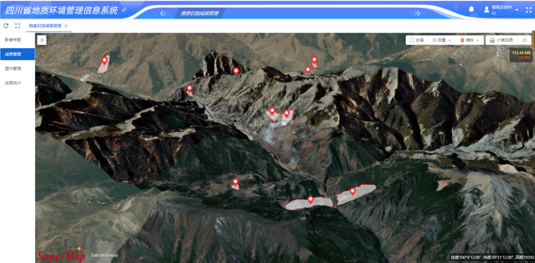
▲ 3D distribution of hidden disasters
Based on the spatial analysis function of 3D geographic information and combined with geological operation data for geological disaster risk assessment, the system established a terrain-level real-scene 3D model, analyzed the scope of influence of geological disaster points and the land use within the scope, and displayed them with spatial visualization technology, providing more intuitive auxiliary functions for the identification, analysis and management of hidden dangers.
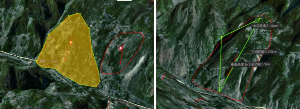
▲ 3D measurement and analysis
Through the application of optical remote sensing and time-series InSAR technology, the system can effectively capture the surface deformation before the landslide, providing a very effective means for early identification and discovery of landslide hazards that are slowly deforming.
▲ InSAR deformation monitoring and recognition
Hierarchical management scientific early warning
“Double sure” for Earthquake Monitoring
Professional monitoring and early warning are important means of scientifically preventing geological disasters. The system is based on the air-space-ground three-check system, combined with the manual investigation, most hidden dangers of geological disasters can be found.
It supports: assign tasks level by level → the inspection team conducts field inspections and reports hidden danger information → the superior department evaluates the reported hidden dangers and feedbacks the evaluation results → the inspection team
The system has established a scientific monitoring and early warning system, which can track and manage hidden geological hazards such as collapses, landslides, and debris flows, and conduct risk investigation, group monitoring and prevention, relocation and avoidance, and law enforcement supervision, etc., to minimize casualties and property losses, to further maintain social stability.
Support indoor and outdoor collaborative work
Creating "Smart Benefits" for earth disaster verification
The system supports the simultaneous issuance, verification, review, and supervision of hidden danger tasks on the PC side and the verification APP. It also supports information filling in both online and offline modes in the field to ensure the preservation and timely reporting of verification information under special circumstances such as no signal. Through indoor and outdoor collaborative work, the system can ensure that the relevant departments of geological disasters give timely feedback on the hidden danger verification and evaluation, and processing results, and reporting them to the provincial platform.
Multi-service linkage and sharing
Assisting in the whole process management of disaster prevention and control
The hidden dangers identified by the system will be used in geological disaster investigation and evaluation, monitoring and early warning, emergency command, avoidance, and comprehensive management, etc., to realize the whole process of geological disaster prevention and control, including identification, investigation, discovery, prevention, governance, and write-off.
Summary
The system adopts the technologies of "air-space-ground" integrated InSAR monitoring, high-precision remote sensing, and UAV aerial photography. It will continue to carry out early identification and evaluation of geological hazards in a targeted manner and realize the identification of geological hazards based on remote sensing.