Introduction: Tongchuan geological disaster monitoring and early warning management platform integrates human work and technologies, innovating geological disaster monitoring methods and prevention measures, and improving the early detection and early prevention of geological disaster hidden dangers.
Natural disasters have been with human beings since ancient times. Traditionally, disaster management purely by humans has been the primary and single method. For instance, in the group management, we used the telephone, document, and other communication tools to exchange information; however, it is incapable of data-trace, management, and historical data analysis. Such a mere labor method finds it difficult to detect some creeping landslide or landslide with slow displacement change and has shortcomings in all-weather monitoring and effectiveness, which is to the disadvantage of danger detection and trend prediction.
>Project Innovations
•Human-Technology Management Pattern for Geological Disaster Monitoring and Early Warning comprehensively improves the geological disaster prevention and control
Through the combination of labor work and information technology, the platform has optimized the reporting process and shortened the time for early warning of hidden dangers. This project has built a group monitoring&prevention grid system in response to hidden dangers and threats of geological disaster, where human defense is the major method and geological disaster monitoring and early warning system the auxiliary means. It can prevent hidden dangers in advance, and enable people to quickly discover and report dangers.
Technology scheme in geological disaster monitoring and early warning information construction
The informatization construction of geological disaster monitoring and early warning adopts the platform cloud architecture, and the technical scheme includes the following aspects:
1. (The system software design) Adopt layered architecture technology, rely on the front-end and back-end separation architecture, and utilize mainstream Web technology and standard service interface development.
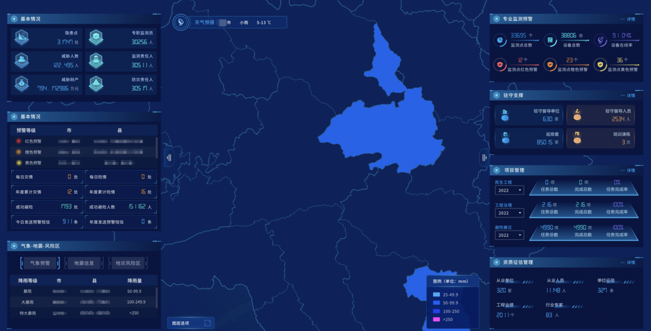
2. Integrate data based on GIS one-map mode, integrate and distribute data for Internet of Things data and geological thematic data.
3. Use the Internet of Things monitoring, early warning big data analysis, and timely communication technologies to build an all-weather monitoring and early warning perception system.
4. Integrate monitoring data and real-time information to communicate with terminals to provide GIS 3D digital sand table for personnel command dispatch in early warning.
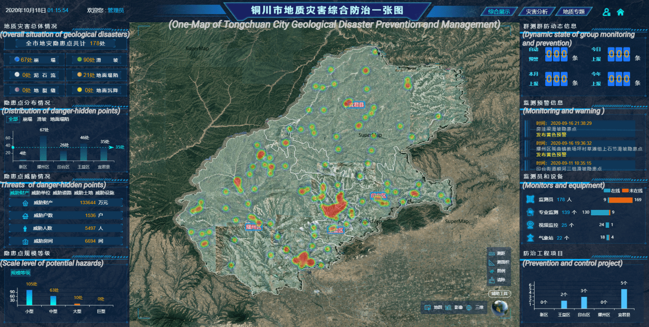
Tongchuan Geological Disaster Monitoring and Early Warning Management Platform
Key technologies and innovative approaches
The project construction adopts informatization technology in geological disaster prevention and control business for a deep integration:
1. Innovate the previous loess landslide monitoring and early warning model algorithm. Most of the geological disasters in Tongchuan City are Weibei(a region on the Loess Plateau) loess landslides. We innovatively built an early warning model for this type of landslide, calculating the tangent angle of the landslide variable rate based on the Xiyuan model, conducted the qualitative and quantitative calculation of the tangent angle for an automatic early warning system.
2. Use advanced GIS three-dimensional maps to assist in the layout of professional monitoring equipment. According to the geological hazard survey data, survey the objects within the landslide mass, infer the location of the cracks, combine the survey data with the GIS three-dimensional map, and reasonably plan the location of monitoring stations.
3. Using GIS three-dimensional scene + Internet of Things to realize dynamic monitoring of geological disaster deformation. Realize the visualization of the deformation monitoring data of geological disaster points based on the 3D digital sand table, analyze the deformation trend of the sliding mass in combination with the geological characteristics, assist users in comprehensive research and judgment, early warning, and emergency command.
4. Real-time convergence technology-based on BeiDou monitoring sliding mass deformation data. This technology can monitor the deformation data of geological hazard bodies around the clock and send it back to the early warning center, realizing real-time collection and storage of multi-device monitoring data and big data calculation.
>What users say
Combined with the status quo of geological disaster prevention and control in Tongchuan City, this system has enriched geological disaster monitoring methods, optimized geological disaster management mechanisms, and strengthened the training of geological disaster prevention and control professionals. Tongchuan City’s geological disaster prevention and control have been transformed from passive management to active prevention and control and from lagging management to source management.
Since the official operation of the platform, there have been 351 automatic early warnings, including 218 blue early warnings, 112 yellow early warnings, 18 orange early warnings, and 3 red early warnings. The responsible person in charge of geological disaster prevention and control in the jurisdiction was notified in time through text messages and other handy means. All localities have stepped up inspections and urgently dealt with dangerous situations according to the early warning information.
Author: Wang Yajun, SuperMap Platform Business Group
Click Tags below for more about One Map