Utilizing technologies of GIS, 5G, Internet of Things, big data, digital twins, SuperMap geological disaster prevention and management platform adopts the “1+1+N” model: one geological disaster big data center, one geological disaster prevention basic information platform and N applications of intelligent prevention and control of geological disasters. This platform promotes the transformation of geological disaster prevention and control from “human defense as the focus” to “combining human and technology”, from "group measurement and prevention" to " group measurement and group prevention, combined with special groups", and from "passive governance" to "active prevention and control", from "lag management" to "source management".
Full-coverage Big Data Center for precise prevention and control of geological disasters
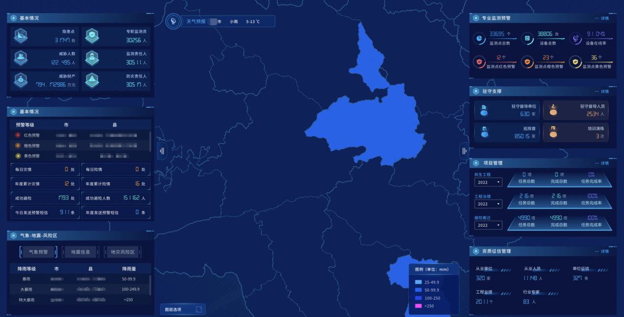
The platform gathers multi-source data such as survey monitoring, application features, basic geography, remote sensing images, etc., integrate relevant data from environmental protection, water conservancy, meteorology and other departments, builds a core database for comprehensive prevention and control of geological disasters, forming a data management and application mechanism, and establishing big data center for geological disasters, to monitor, early warn and prevent geological disasters.
Basic Information Platform for intelligent prevention and control of geological disasters
Through centralized management and distributed computing of geological disaster big data, decoupling of software functions in a lightweight way, dynamic scaling of cloud application software, and application scenes quickly constructed by business systems, a basic information platform for geological disaster is built.
Relying on the big data of multi-source heterogeneous geological disaster investigation and monitoring, a risk management and control early warning model is built to provide services such as dynamic monitoring and early warning, professional analysis and evaluation, trend prediction and analysis, situation simulation and auxiliary decision analysis.
Application System for full-cycle refined management
• Early identification system
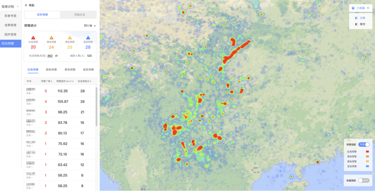
It makes full use of photogrammetry and remote sensing technology, combined with mobile inspection, integrates multi-source monitoring data of "air, space and earth", establishes a multi-source heterogeneous identification and analysis database, an identification and analysis results of geological hazards database, and forms a spatial data system for identification and analysis of geological hazards. The early identification system for prevention and control is built for source control and management.
• Survey and appraisal system
Combined with satellite remote sensing, UAV aerial photography, InSAR, LiDAR, professional instruments (such as rain gauges, crack meters, inclinometers, etc.), on-site inspection and verification, according to the basic data of investigation and monitoring, a risk scoring mechanism is built for investigating and evaluating hidden dangers, forming a new mode of geological disaster monitoring and early warning of "human defense + technical defense".
• Risk management and early warning system
Relying on the early warning model of hidden danger risk management and control, we have created a 4-level early warning and response mechanism of "red, orange, yellow and blue" for "7x24" all-weather geological disasters. The yellow and above early warning information is sent to the relevant responsible person for the first time through phone messages, mobile apps, etc. For the red early warning, loudspeakers, broadcasts, hand sirens, and fireworks can be used to remind people.
• Project management system
This system support data analysis and visual display of the basic situation of the project, capital investment, project progress, governance benefits, etc.
• Fund supervision system
This system supports the whole-process supervision from fund receipt, release, filing, and review to execution
• "One Map" application system
It is a comprehensive system integrating multi-source data online analysis, display, monitoring, early warning, and emergency support.
For major geological disaster projects, 2D and 3D GIS technology and AR/VR technology are used to quickly restore the accident site, accurately assess the disaster level and scope of influence, and combine game engine technology to simulate emergency rescue and disaster relief plans to determine the best mass evacuation and transfer routes.
• Intelligent decision-making and dispatch system
This system supports a dynamic display of management performance evaluation on maps and various statistical charts (such as column charts, ring charts, pie charts, radar charts, etc.)