SuperMap logo
  • Products

    What is GIS

    About SuperMap GIS

    Technology System

    • Big Data GIS
    • New RS Software
    • New 3D GIS
    • Geospatial AI
    • Distributed GIS
    • Cross Platform GIS

    SuperMap GIS 2024 New!!

    • Cloud GIS Server
    • Edge GIS Server
    • Terminal GIS for Desktop
    • Terminal GIS for Components
    • Terminal GIS for Web
    • Terminal GIS for Mobile

    Previous Versions

    • SuperMap GIS 2023
    • SuperMap GIS 11i(2022)
    • SuperMap GIS 10i(2021)
    • SuperMap GIS 10i(2020)
    • SuperMap GIS 10i
    • SuperMap GIS 9D(2019)
  • Solutions

    Smart City

    Natural Resource

    Land Management

    Facility Management

    Public Safety

    Natural Disasters

    Transportation

    Water Conservancy

    BIM+GIS

  • Stories
    • Articles
    • News
    • Events
    • Magazines
  • Support
    • Download & Online Help
    • Online Demonstration
    • Ask & Answer
    • Discover SuperMap GIS
    • Trial License
  • About
    • lntroduction
    • Careers
    • Contacts
    • Suggestions
 
  • English
  • 中文
  • Español
  • Français
  • ภาษาไทย
  • русский
  • Türkçe
  • Português
  • 日本語
  • 한국어
  • Indonesian
  • عربي
Public Safety

Public Safety Solutions

  • Home
  • Solutions
  • Public Safety

Public Safety

  • BIM
  • Disasters
  • Land
  • Water
  • Transportation
  • Safety
  • Facility
  • City
  • Resource
  • Command System Projects

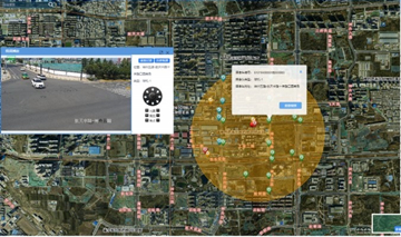
    The city public security command system comprehensively improves the capability of emergency response and the efficiency of the public security policing.

    10 Oct,2019
    Command System Projects
  • The 3D Police Electronic Map System

    The project mainly constructs a real-time 3D geographic information platform with a total area of 10 square kilometers in the main city area, and a 3D scene data model for building an indoor real-scene of 50,000 square meters.Thro…

    20 Sep,2019
    The 3D Police Electronic Map System
  • The Smart Community Police Platform

    With the advent of the era of knowledge economy and network economy, the traditional community police working mode will gradually transform into an information-based and intelligent working mode.

    12 Sep,2019
    The Smart Community Police Platform
  • The Police Big Data Platform

    Based on SuperMap 9D, the 2D and 3D integrated police big data platform was developed, which includes a big data application system for visualization?police, a police resource management system, and a police information sharing platform. The?pla…

    14 Aug,2019
    The Police Big Data Platform
  • The 3D Spatio-temporal Big Data Police Platform

    As?the increasing needs of public security police for big data and police drone service, it is needed to build a 3D?big data police?platform?through deploying a high-performance graphics and image rendering engine in the public securit…

    06 Aug,2019
    The 3D Spatio-temporal Big Data Police Platform
  • The Dangerous Chemicals Handling and Transportation Visualization Display System

    Based on SuperMap 9D?technology, the SuperMap partner company?develops the Dangerous Chemicals Handling and Transportation Visualization Display System?which?includes five modules: one map, precision monitoring, comprehensive pre-warni…

    29 Jul,2019
    The Dangerous Chemicals Handling and Transportation Visualization Display System
  • 3D Visualization in Safety Supervision

    In order to implement the requirements of the Ministry of Transport on the safety supervision of dangerous goods in ports, improve the safety supervision of major hazard sources in ports and strengthen the sharing of information resources of major hazard …
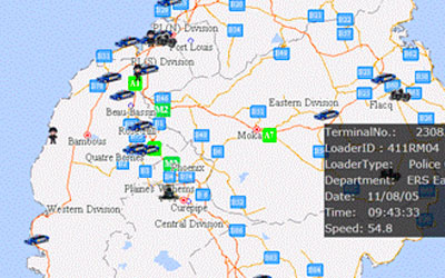
    19 Jun,2019
    3D Visualization in Safety Supervision
  • Mauritius Police GIS

    System IntroductionThe Mauritius Police GIS (MPGIS) is a customized GIS application for Mauritius Police Force (MPF). MPGIS is part of the CCTV for Port Louis and Grand Bay project (CCTV System), which is a Chinese Foreign Aid project for Mauritius, and i…

    18 Jun,2019
    Mauritius Police GIS
  • 3D GIS Technology Assists the Informationization of Public Security of Large-scale Events

    When compared with traditional 2D GIS, 3D GIS is more realistic because it is closer to human visual habits. It can not only express the plane relationship of spatial objects, but also describe the vertical relationship between them. With the rapid develo…

    06 May,2019
    3D GIS Technology Assists the Informationization of Public Security of Large-scale Events
<<< < 1 2 > >>>

SuperMap GIS

  • Cloud GIS Server
  • Edge GIS Server
  • Terminal GIS for Desktop
  • Terminal GIS for Components
  • Terminal GIS for Web
  • Terminal GIS for Mobile

Stories

  • Articles
  • News
  • Magazines
  • Events

Support

  • Download & Online Help
  • Online Demonstration
  • FAQ
  • Demo Code
  • Technical Docs
  • Training Files
  • Videos
  • Trial License

Events

  • [list:pagetitle] [list:targetlink]
  • {/zzz:list}

About

  • lntroduction
  • Careers
  • Contacts
  • Suggestions

Follow Us

  • LinkedIn
  • Facebook
  • Twitter
  • Instagram
  • YouTube
© 1997-2023 SuperMap Software Co., Ltd.
  • Sitemap
  • | Privacy