The 24th Olympic Winter Games was held in Beijing and Zhangjiakou (in north China’s Hebei Province) on February 4, 2022. Compared with the Summer Olympics, the Winter Olympics, especially the snow sports held outdoors, are more susceptible to weather conditions. The wind speed, wind power, temperature, and snow temperature can directly test the technical performance of athletes. Therefore, intuitive and efficient meteorological services and assurance are indispensable in this event.
Beijing Meteorological Bureau and SuperMap have jointly developed a climate risk assessment system based on the SuperMap GIS platform for the Winter Olympics. It has provided great support for the venue selection and event schedule of the Winter Olympics by making full use of high-tech means.

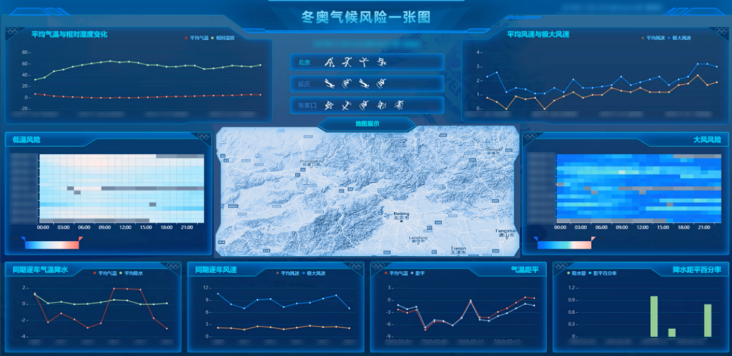
One-Map of Winter Olympics Climate Risk
This system, combining the characteristics of the Winter Olympics meteorological service, provides a climate risk assessment product covering the entire venue through a multi-scale, multi-dimensional, and multi-perspective fusion analysis of the Winter Olympics competition areas and venues. Based on climate risk assessment through the comparison and analysis of historical long-sequence data and real-time monitoring data from automatic stations, this system, according to the requirements of the safe operation of the Winter Olympic Games, produces products for venue maintenance and in-competition risk assessment, which has optimized meteorological services.
The system performs data fusion analysis from different dimensions such as time, space, and Meteorology elements:
Space: By manes of GIS spatial visualization technology and graphical means, it supports meteorological risk assessment and analysis of each venue in Beijing, Yanqing, and Zhangjiakou competition areas.
Time: It supports real-time weather data analysis by the hour and day, historical data analysis of the Winter Olympics and Winter Paralympics, and historical extreme weather conditions analysis.
Meteorology: It conducts meteorological risks analyses such as low temperature, strong wind, precipitation, sand and dust storms, haze, etc., which are closely linked with the games.
Through the GIS One-map technology, the system can clearly and effectively display the distribution, climate characteristics, and meteorological risks of each project venue in the three competition areas, which are a buttress to the decision-making of the Organizing Committee.
Article source: China Association for Geospatial Information Society (The China Association for Geospatial Information Society (CAGIS) is a first-level, registered, national non-profit organization, authorized and supervised by the Ministry of Civil Affairs and the Ministry of Natural Resources.)