The goal of the system
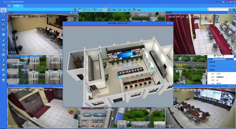
Guangdong Weihao Intelligent Technology Co., Ltd. and SuperMap cooperated to build a campus security system for Huazhong Agricultural University. Based on three-dimensional geographic information, the project integrates equipment, pipe network and data resources for energy management, operation and maintenance and services, and builds a campus security system that integrates water, electricity, gas, and fire-fighting facilities and equipment management, decision support analysis, and event early warning. The system breaks down information silos and supports collaborative work. It digitizes and visualizes water and electricity supply and distribution, and fire pipeline management. It acts as an auxiliary means for the campus’s energy management and operation, dispatching and commanding, and energy-saving supervision.
Construction of the System
1. 3D data collection and database building
This project completed the 1:500 digital map of the whole school within 5 square kilometers and 150 kilometers of pipelines (power pipelines, water supply and drainage pipelines, fire water supply pipelines, water and electricity meters, water supply valves, fire valves) and their ancillary facilities measurement, collection and database building, BIM modeling of more than 60 power distribution stations and box-type electricity substations in the school. It includes database building of underground facility data, database building of special pipeline data, database building of underground pipeline archive data, etc.
2. 3D platform
The project enables the comprehensive display of geographical information spatial data, pipeline (network), energy data, decision-making guarantee, guarantee plan, early warning, alarm equipment positioning, smoke sensor, temperature sensor, infrared, water quality monitoring, sewage monitoring, data query and statistical analysis, and reserve data and information push interface.
The requirements for main functions are as follows:
Layer type
The system should have four basic layers: 2D layer, terrain layer, 3D layer, and single layer.
Calculation and analysis function
Provides a variety of basic 3D measurement functions, including but not limited to space, ground, level, area, elevation, etc.
Object manipulation function
It supports creating geometric objects such as points, vector lines, surfaces, text labels, 3D bodies, 3D models, and particles in the scene; supports modifying the terrain effect, surface excavation area, and oblique data flattening range within the scope of the object by editing the object. It supports continuous clicking and selection of multiple vectors and model objects, supports editing the position and shape of vectors and model objects through translation, rotation, and scaling operations, and supports real-time editing of surface excavation areas and depths.
Scene expression function
It enables the practice of creating scenes, adding 2D and 3D data, setting layer properties and layer styles, drawing objects, and making thematic maps; supports 2D and 3D terrain, images, models, vectors, maps and other scene elements; supports special environmental effects, realistically simulating the environment and light and shadow effects of the earth.
Scenes, special effects and browsing functions
The system supports real-time browsing, query, and editing of 2D and 3D data in the scene; it supports many practices on the scenes: zoom in, zoom out, tilt, level up, rotate, zoom, fast positioning, and rotate the camera at any angle, point to the north, adjust roaming operations such as pitch angle. It enables the automatic browsing of scenes from different azimuths and different angles, and enables the effect of the smooth transition of deceleration and turning during the process.