Introduction
Chengdu Main Urban Zone Fresh Food Cold Chain Service System is an award-winning work of the SuperMap GIS Contest. This work takes the fresh food cold chain service system in the main urban area of Chengdu as the object, based on relevant data such as the fresh food retail store information in the research area, uses SuperMap GIS software to complete spatial data processing, mapping and system development, forming a fresh cold chain service system on network + WeChat applet.
The team developed the front-end and back-end frameworks based on SuperMap iClient JavaScript 11i in the browser terminal and the WeChat applet terminal, adding diversified customization functions, visual display and user interaction to enhance the user experience.
System function design
This system integrates rich online spatial analysis and data statistics services, cool data visualization, and a practical large visual screen, realizing multi-terminal data collaboration. The system has been designed from the perspective of multiple users from the beginning of the design, providing a reference for demand solutions for cold chain service operators, fresh food suppliers and ordinary users.

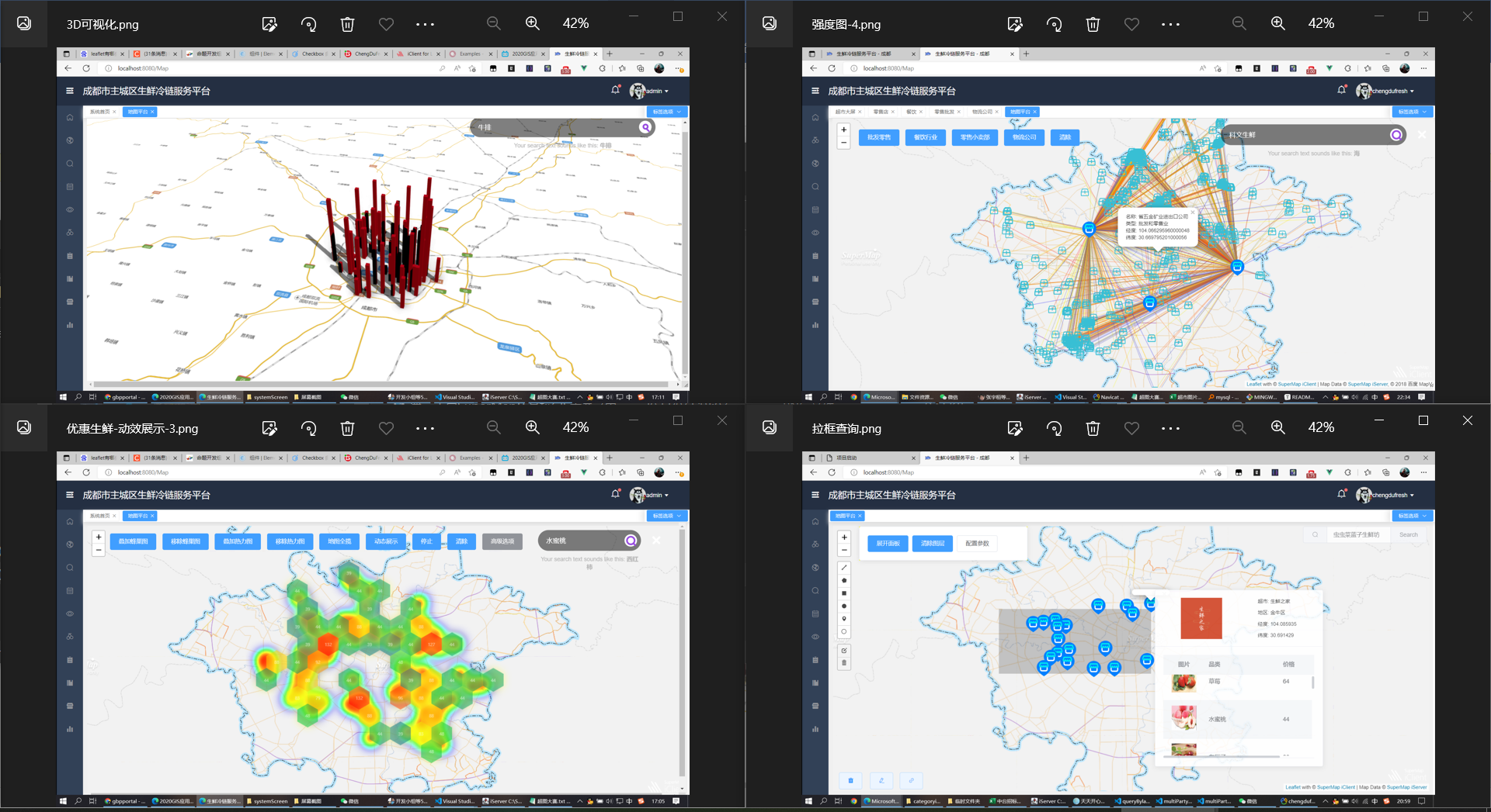
• Project homepage and interactive function bar
The homepage effectively demonstrates the key information through the reasonable collocation of multiple components, so that cold chain service operators can quickly obtain the required information. The left toolbar allows users to quickly use the functional tools.
• Function beautification and data visualization
Combined with the user experience and the practicability of the project, the team has extended and beautified the proposition requirements. The system not only uses a variety of spatial analysis services to achieve rich functional modules, but also makes exquisite pop-up windows for different functions.
• Fresh supermarket management dashboard
Considering that there will be multiple users in practical applications, the team developed a browser PC terminal for operators, a supermarket visualization dashboard for suppliers, and a small program terminal for ordinary users.
• Project framework
The system architecture is divided into four layers, including the data layer, application support layer, operation logic layer and presentation layer. It combines MySQL to achieve multi-directional database data query and management functions, combines SuperMap iServer and spatial databases to realize geographic information services and user interaction functions, to ensure hierarchical services on the Web browser side and WeChat applet side.
About the web browser, in the system, a set of web service platform was developed, which was based on Vue3 and ElementPlus to build the overall framework of the platform, use Node to build the server, and use the SuperMap iClient for Leaflet to load the relevant service interfaces released by SuperMap iServer, to achieve the geographic information analysis function of the platform, and use Navicat and other database management tools to manage and call the data tables of the MySQL database to achieve the database management function of the platform. The system also uses Echarts and MapboxGL to support data visualization functions, improving the practicability and the beauty of web page presentation.
System highlights
1. Considering the actual use environment of the cold chain system, different systems have been customized and developed for multiple users to maximize the advantages of the system, multi-terminal collaboration, and data sharing;
2. A variety of query methods were developed to enable users to make full use of data;
3. The pop-up window components are elaborately made for each functional module, so that users can have a good experience;
4. Highly personalized customization enables the role of functional modules to be fully released;
5. Rich visual development allows users to intuitively and effectively obtain the required information;
6. The information management module effectively organizes discrete data for easy management and mining.
The data of this system mainly comes from the official price data of fresh cold chain commodities, data of fresh food supermarkets, and address data of potential fresh food demand in the main urban area of Chengdu, which is crawled by Python network, and downloads from related websites. We process the data with the help of GIS technology. After obtaining the official tabular data and other data, we use SuperMap iDesktop to visualize the data and make maps, and publish them to the SuperMap iServer service. Then, using Vue and SpringBoot frameworks as carriers, combined with various geospatial analysis service models and data visualization technologies, the fresh commodity price information and map data are displayed from multiple angles and in multiple forms to meet the corresponding user interaction needs.
The system is oriented to the fresh food cold chain service system, which can not only meet the marketing management of service providers, but also satisfy the public’s quick query of fresh product stores and products, and support the query and planning of fresh food cold chain distribution routes, providing a geographic information technology solution for fresh food cold chain.
“Chengdu Main Urban Zone Fresh Food Cold Chain Service System” integrates technologies such as GIS, big data analysis, mobile Internet, map visualization and expression, which well demonstrates the application of GIS data and technology in daily life, and provides relevant industries with reference.