The Lhasa Municipal Natural Resources Bureau has built a set of integrated natural resources management models with snow-covered plateau characteristics based on the overall construction framework of one network, one map, one platform, and N applications, which has improved the overall digital level and government service capabilities as a whole.
"Five steps" to build One Network, One Map, One Platform, N Applications
Data resource system construction
Relying on major special projects such as natural resource investigation, evaluation, monitoring and planning organized and implemented by natural resource departments at all levels, and in accordance with relevant technical standards and specifications, the platform sorts out, organizes, combines and stores massive, multi-source, and heterogeneous data of different categories and specialties. On this basis, relying on the platform, relevant data governance work has been carried out, and the spatial data stored in the city has been gradually integrated to form a natural resource and planning data resource directory system that is in line with the actual operation of Lhasa and meets the needs of management applications.
Up to now, the platform has access to four categories of current data, planning data, management data, and social economy, with a total of 479 data resource services, mainly including administrative division data, land change survey from 2012 to 2018, the city’s ecological protection red line, and land use approval , Lhasa City’s regulatory planning, agricultural land conversion and increase/decrease linkage, benchmark land price, land consolidation and other data, basically formed a data base map with consistent coordinates, seamless connection, and dynamic update.
In the next step, with the advancement of the preparation of national land and space planning, the platform will continue to update and improve, expand and supplement the results of national land and space planning, including the data of three districts and three lines, special planning, etc., to lay a solid foundation for the supervision of planning implementation.
Technology platform construction
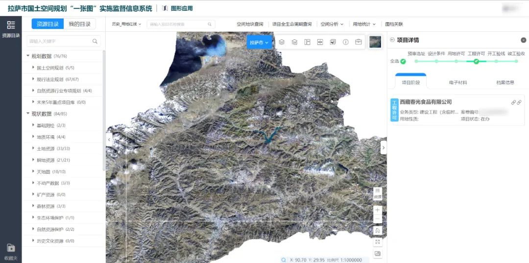
The platform adopts the unified platform model shared by the city and county under the overall planning of the Municipal Bureau, and builds the basic land and space information platform based on the achievements of Lhasa’s natural resources informatization construction, and implements the “unified base map, unified standard, unified planning, and unified platform”. The One Map of land and space planning covers the whole city, which is dynamically updated, and authoritatively unified, and achieves unified collection, quality inspection, extraction, integration, storage, update, and supervision of data resources.
Construction of application service system
The platform builds a full-service administrative approval system to realize the whole process of business from comprehensive acceptance at the administrative approval window to internal approval; builds a 3D management system to realize comprehensive display of 3D model results, visualized 3D assisted approval, and spatial analysis assisted decision support.
Data exchange platform construction
On the basis of security, the platform has the functions of government affairs management platform, government affairs service platform and mobile office data exchange, which improves data activity and makes data reuse possible. It meets the data sharing and exchange needs of different administrative departments.
Basic environment construction
The safe and efficient construction of the platform conforms to the "one network" of natural resources required by the overall plan of the Ministry of Natural Resources. It improves the construction of the private network for natural resources operation, and connect it to the operation backbone network of the Ministry of Natural Resources, and fully implement the network security level protection; the application adopts cluster deployment, provides load balancing function, and establishes a complete business network system while ensuring the efficiency of the platform server, laying a solid foundation for future adjustment and optimization.
The initial success of the platform application
The project was officially launched on December 24, 2019; in October 2020, the system design, development, testing and deployment were completed; in November 2020, the system was put into trial operation; in April 2021, the project acceptance was completed. So far, the system is running normally and stably.
After the system was officially launched, the system has been used globally for official document handling and business approval. The whole process is handled online. Through the three-dimensional management system and the “one map” of natural resources, land and space planning, the implementation of the supervision information system is used for auxiliary approval, which has improved the working efficiency of local natural resources bureau. The system has preliminarily established a shared service platform and mechanism based on natural resource data and operation, allowing the digital resources of the Lhasa Natural Resources Bureau to be used by the whole city to promote collaboration, support management, and continuous service. According to Lhasa Natural Resources Bureau, after the system was put into use, the average processing time was reduced by 1.5 days, and the approval efficiency increased by 25%.