Wetlands are always ecologically fragile and monitoring and early warning are indispensable in their conservation. SuperMap and its partner Attiot jointly constructed a wetland ecosystem monitoring and early warning platform for Poyang Lake, the largest freshwater lake in China.

Source: Jiangxi Poyang Lake National Wetland Park
Construction objectives
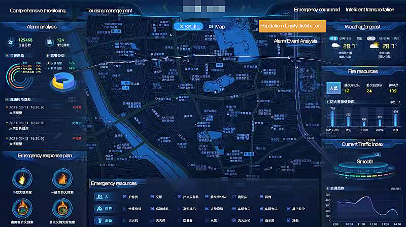
The basic warning analysis management system includes a video monitoring analysis system, wetland change monitoring system, wetland comprehensive evaluation system, and warning information release system. The warning information system will release the results of the analysis and evaluation to government departments, research institutions and the public via the Internet. The early warning analysis management system can monitor, warn and issue the ecological security, wetland changes, birds, vegetation and human activities of the whole Poyang Lake wetland system in quasi-real-time.
Construction content
1. Purchase of 3D GIS software and large screen system of GIS comprehensive control
Purchase a set of desktop GIS software and 3D service GIS software;
Develop four functional modules of the cockpit, video monitoring, environmental monitoring, wetland GIS map.
2. Video data processing and control system
Streaming media conversion and push;
The discrimination of migratory bird species and numbers is based on the video, and AI image recognition technology is used to realize the real-time analysis of vegetation index, bird capture and recognition, and human activity trail capture alarm;
A weekly monitoring report can be customized for the distribution of birds and human activities in the whole Poyang Lake area;
The system provides the functions of archiving and playing back system video files, and the system supports the functions of live broadcasting and querying and playing back the selected period.
3. Space-Air-Ground Integrated Wetland Change Monitoring system
Real-time coordinate fusion based on UAV monitoring data, wetland change monitoring data in video and remote sensing data;
Monitoring and analysis of wetland area change in Poyang Lake;
According to the spatial analysis and evaluation model, the landscape index analysis method was used to make statistical analysis on the changes of Poyang Lake wetland, to generate a weekly monitoring report and output mapping of the whole region;
Develop modules for customizing results reports to support different media releases.
4. Model-driven wetland health assessment system
According to the monitoring data collected by relevant monitoring stations built on the platform, spatial interpolation was carried out based on the existing monitoring data, and the evaluation model was substituted into the monitoring data to preliminarily form the evaluation results of wetland health environment, and form the spatial distribution map of the whole lake;
The final environmental monitoring and evaluation results are formed by supplementing and revising data through public feedback and expert field investigation;
A comprehensive evaluation index system is adapted to output an evaluation report every month;
The real-time monitoring index system is adapted to output an evaluation report every week;
Output evaluation reports within six hours of the emergency;
Develop a module to customize the format of the results report to support publication in different media.
5. Monitoring and Early Warning Results Release System
A public warning system;
Business unit's early warning system.
6. Application Support and Operation and Maintenance Management System
Application support subsystem;
Integrated operation and maintenance subsystem.