Based on the remote sensing data of the Gaofen-2 satellite, Unionbigdata has built a big data analysis system for remote sensing of rivers and lakes in Chengdu for the Chengdu Smart Governance Center. The core mechanism is that water that is clean, malodorous, or rich in green algae or silt will show different spectral characteristics due to the different contents of suspended solids, Chlorophyll, sediment, and other substances. AI technology is utilized to automatically interpret remote sensing images, accurately reproduce the distribution of polluted water bodies, and realize the overall perception of water pollution in Chengdu. At the same time, through the integration of Internet of Things data and network management data, from macro to micro, we can comprehensively grasp the distribution of rivers and lakes, the situation of water pollution, and the evolution trend of pollution.
(1) Technology roadmap
First, the remote sensing images were divided into 36,000 grids, the cloud coverage of each grid was analyzed, and the grid with the lowest coverage was used as the base to fuse a complete cloud-free image to eliminate the influence of clouds.
Then, the DenseUNet deep neural network is used to learn tens of thousands of water body sample data sets to obtain a water body extraction model, and the original remote sensing data is input into the water body extraction model, which can quickly and accurately perform large-scale automatic extraction of water bodies, and calculate regional water network density index according to the extraction results.
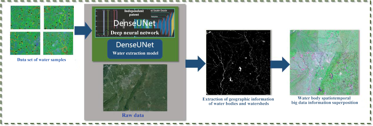
Finally, by analyzing the differences in the spectral responses of different pollutant components in the water, an index inversion model was constructed to calculate the contents of chlorophyll a, colored dissolved organic matter (CDOM), suspended sediment (SSSC), and other substances in the water body to identify the types of water pollution (malodorous water pollution, water eutrophic pollution, sediment pollution), assess the degree of different types of pollution, and establish a comprehensive sensory index of water quality.
(2) Digital performance
In terms of river and lake resource monitoring, the system has identified more than 1,200 water resource objects, with a total area of about 340km². In terms of water pollution monitoring, compared with the list of 41 black and odorous rivers and canals officially published, we found that 37 of them were significantly improved. In addition, 3 other black and odorous water bodies and 4 water bodies with high sediment content that need further attention were detected.
(3) Application direction
In the future, with the continuous accumulation of remote sensing and related data, we will further explore the identification of illegal encroachment of water bodies, the evolution trend of the water body area, etc., and form a demonstration application that can be applied in more areas.