In recent years, China has attached great importance to the management of natural resources. In 2015, the national underground water project was officially launched. SuperMap Group has undertaken the task of constructing information systems related to hydrology, water resources and geological and mineral resources. With the new 3D GIS platform software, SuperMap has built the 3D application systems and platforms, such as underground water resources information release systems, model systems and the comprehensive geological survey information platform, which have achieved remarkable results.
Underground Water Management Based on Mobile Applications
The platform takes 4G wirelesses Internet as the carrier and combines embedded technology, GPS technology and GIS technology to realize the comprehensive inquiry and browsing, statistical analysis, GPS positioning and surroundings inquiries of underground water resources information on mobile. The platform can release various types of underground water resource information and warning information to the public to meet the needs of relevant personnel and to better serve the management of underground water resource.

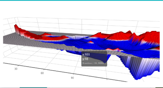
The water level of the over-exploitation area (year of 2000)

The water level of the over-exploitation area (year of 1980)
3D visualization application in underground water over-exploitation
Based on new 3D visualization method, the platform can realize the dynamic visualization of underground water. With the water level data, the groundwater level model can be constructed by 3D spatial analysis technology. The platform can directly display the underground water situation.
The 3D display of the over-exploitation area can visually display the groundwater conditions in 3D scene and analyze the formation causes of the over-exploitation area by means of horizontal-vertical methods and the status of the underground water, with the historical situation and layers of superimposed images and rivers. This can support the subsequent over-exploitation mining and the replenishment in over-exploitation area.
At present, the application fields of the underground water resource management platform based on SuperMap new 3D GIS technology has expanded from water conservancy to other natural resource fields. In the future, the platform will further coupling of the professional numerical models in 3D GIS and natural resource to provide scientific and favorable supports for underground water resource management, over-exploitation comprehensive management and comprehensive management of land and space.

New 3D GIS Technology in Underground Water Management>
2D and 3D GIS in Natural Resources Management>
New 3D GIS Technology Supports the Construction of "Digital Twins" in Transportation>