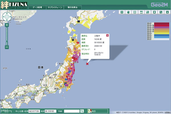
SuperMap logo
  • Products

    What is GIS

    About SuperMap GIS

    Technology System

    • Big Data GIS
    • New RS Software
    • New 3D GIS
    • Geospatial AI
    • Distributed GIS
    • Cross Platform GIS

    SuperMap GIS 2024 New!!

    • Cloud GIS Server
    • Edge GIS Server
    • Terminal GIS for Desktop
    • Terminal GIS for Components
    • Terminal GIS for Web
    • Terminal GIS for Mobile

    Previous Versions

    • SuperMap GIS 2023
    • SuperMap GIS 11i(2022)
    • SuperMap GIS 10i(2021)
    • SuperMap GIS 10i(2020)
    • SuperMap GIS 10i
    • SuperMap GIS 9D(2019)
  • Solutions

    Smart City

    Natural Resource

    Land Management

    Facility Management

    Public Safety

    Natural Disasters

    Transportation

    Water Conservancy

    BIM+GIS

  • Stories
    • Articles
    • News
    • Events
    • Magazines
  • Support
    • Download & Online Help
    • Online Demonstration
    • Ask & Answer
    • Discover SuperMap GIS
    • Trial License
  • About
    • lntroduction
    • Careers
    • Contacts
    • Suggestions
 
  • English
  • 中文
  • Español
  • Français
  • ภาษาไทย
  • русский
  • Türkçe
  • Português
  • 日本語
  • 한국어
  • Indonesian
  • عربي
Articles

Articles

  • Home
  • Stories
  • Articles
  • CloudGIS Technology Supports the Management of Supply Chains

    Through Integrating CloudGIS into the supply chain management, using the spatial data management and analysis, as well as the graphical display function, the production and sales processes of the transportation, warehousing, loading and unloading, deliver…

    26 Jun,2019 Cloud GISiclient
    CloudGIS Technology Supports the Management of Supply Chains
  • SuperMap 3D Pipeline Technology

    Pipeline data is the basic information of urban construction and development. In the process of urban planning, designing, construction and management, the complete and accurate pipeline information is?indispensable for the efficient works and …

    24 Jun,2019 3D GIS
    SuperMap 3D Pipeline Technology
  • GIS in Comprehensive Geological Survey

    Building the Comprehensive Geological Survey Information SystemSuperMap makes full use of big data technology, GIS technology, computer network technology and 3D visualization technology to realize the integration of the geological survey results, a…

    21 Jun,2019 China 3D GIS
    GIS in Comprehensive Geological Survey
  • How to Make GIS Smarter in the AI Era

    AI technology can be applied in the field of GIS from the perspectives of Data Mining, Natural Language Processing and Computing.?It can?provide functions of spatial density clustering and intelligent identification of address elements, the extr…
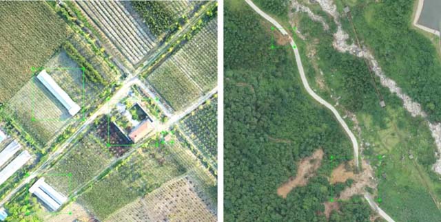
    19 Jun,2019 AI
    How to Make GIS Smarter in the AI Era
  • AI GIS + Remote Sensing Enhances the Ability of Natural Resources Monitoring

    Natural resource survey and monitoring application based on AI+ remote sensingThe AI+ remote sensing detection of image target, the natural resource category segmentation and classification, and natural resource multi-temporal change will provide importan…
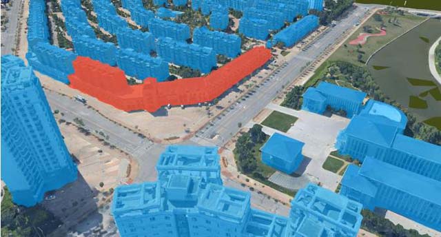
    14 Jun,2019 AI
    AI GIS + Remote Sensing Enhances the Ability of Natural Resources Monitoring
  • 3D GIS Takes 7 Roles in Natural Resources Management

    Transformation of technology and business in natural resource managementWith the in-depth application of GIS, it is increasingly demanding to restore reality in 3D scenes. In technology, 3D GIS has?to turn the geographic data into visible geographic …

    12 Jun,2019 3D GIS
    3D GIS Takes 7 Roles in Natural Resources Management
  • Spatio-temporal Big Data Services Smart City

    The spatio-temporal big data platform is the infrastructure of city, which supports the aggregation, sharing and coordination of various types of information resources for smart city to provide the integration and sharing of urban public information resou…

    10 Jun,2019 big dataSmart City
    Spatio-temporal Big Data Services Smart City
  • Eight Challenges in BIM+GIS Applications - Two

    The integration of BIM and GIS enables the exchange and interoperability of BIM information in the micro-domain and?the GIS information in the macro-domain, deepens?the BIM applications?and extends the application of BIM from a single objec…

    21 May,2019 BIM+GIS
    Eight Challenges in BIM+GIS Applications - Two
<<< < 24 25 26 27 28 > >>>

SuperMap GIS

  • Cloud GIS Server
  • Edge GIS Server
  • Terminal GIS for Desktop
  • Terminal GIS for Components
  • Terminal GIS for Web
  • Terminal GIS for Mobile

Stories

  • Articles
  • News
  • Magazines
  • Events

Support

  • Download & Online Help
  • Online Demonstration
  • FAQ
  • Demo Code
  • Technical Docs
  • Training Files
  • Videos
  • Trial License

Events

  • [list:pagetitle] [list:targetlink]
  • {/zzz:list}

About

  • lntroduction
  • Careers
  • Contacts
  • Suggestions

Follow Us

  • LinkedIn
  • Facebook
  • Twitter
  • Instagram
  • YouTube
© 1997-2023 SuperMap Software Co., Ltd.
  • Sitemap
  • | Privacy