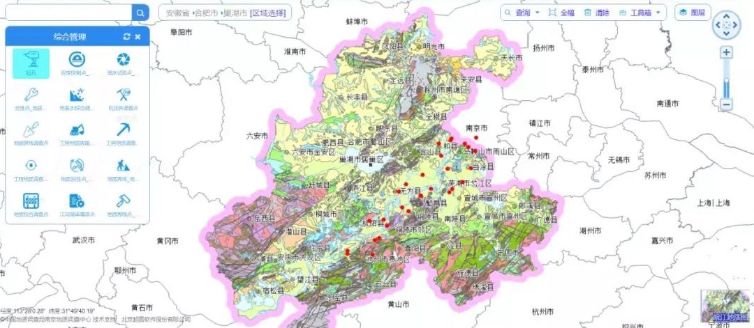
Building the Comprehensive Geological Survey Information System
SuperMap makes full use of big data technology, GIS technology, computer network technology and 3D visualization technology to realize the integration of the geological survey results, and to construct geological environment database and comprehensive geological survey information system.
The system realizes the multi-dimensional big data integrated storage, management, query, analysis, decision-making, 3D visualization and other services, which enables users to manage the related formation services such as geological disaster prevention, groundwater monitoring, land subsidence, mine geological environment protection and resource carrying capacity. It can realize the timely release of important research results, real-time monitoring of the situation and data, and the information sharing and information linkage. At the same time, the system also provides data support for undertaking industrial transfer, optimizing the layout of the country, establishing the river ecological corridor and implementing the new urbanization strategy, serving the construction of geological clouds and the construction of a multi-standard platform for smart cities.
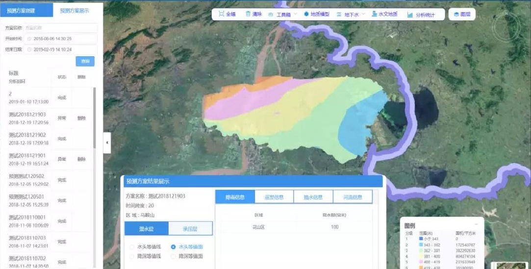
Integrated Modflow Model for Regional Groundwater Simulation Forecasting
SuperMap integrates the Modflow (visual modflow is the most popular and
internationally recognized standard vitalized professional software system for
3D groundwater flow and solute transport simulation evaluation) model
and establishes the groundwater model by analyzing the groundwater dynamics and
the complement, diameter, and drainage conditions. By combining the model
calibrated parameters, the groundwater simulation calculation can be carried out
to determine the average annual underground water resources and exploitation
from different years, and to forecast the groundwater dynamic in different
situations.
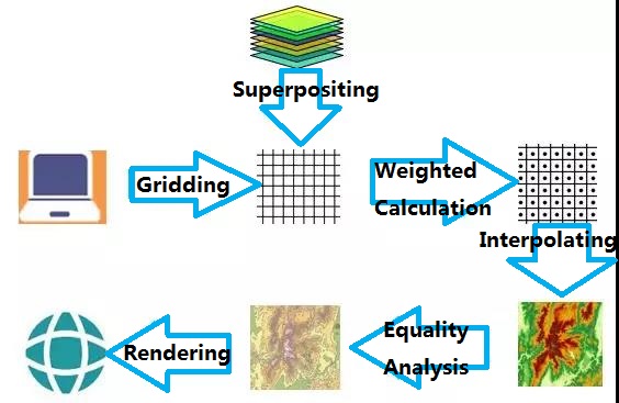
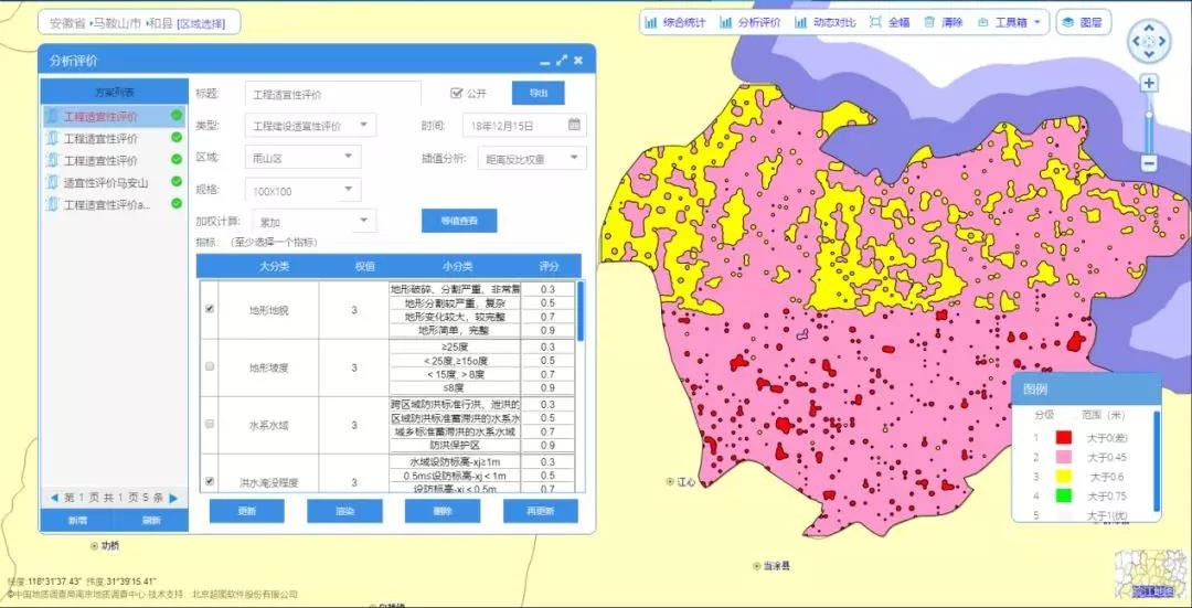
Geological Analysis and Evaluation Based on Grids
By using the GIS spatial analysis function, the system can divide the evaluation area and superimpose the analysis and evaluation factors and the divided grids. According to the geological analysis and evaluation comprehensive index method, the weighting operation is performed to obtain the score of each grid node. The score is adjusted by the interpolation process to form the raster data, which can be dynamically rendered on the map in the form of isosurfaces.
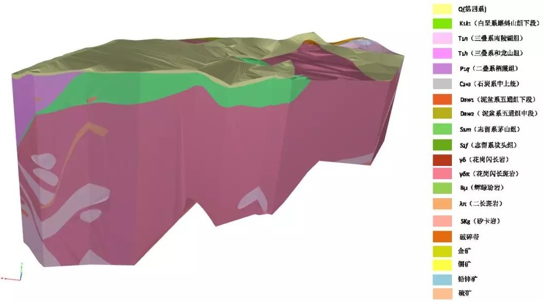
3D Visualization and Segmentation of Geological Models
Using 2D and 3D integration technology, the system visualizes the 3D geological model data generated by each platform, and superimposes the thematic data to carry out 3D geological model plane splitting, polyline splitting and combined splitting, which can display various geological bodies more intuitively and realistically. The structural composition is convenient for users to obtain geological information such as profile maps and geological maps at any position.
Improve the Applications of Geological Survey Results to Support the Planning and Construction of the Land Space
Based on the comprehensive geological survey results database, the geological survey information system fully utilizes cloud computing, big data and other new-generation information technologies to establish a comprehensive geological survey database, which covers business data and spatial data.
In addition, SuperMap analyzes and mines the big data, and analyzes the results to back-check the geological survey, which effectively improves the quality and efficiency of the local construction. In the future, SuperMap will continue to strengthen the exploration of geological big data applications, and propose innovative and forward-looking urban construction practices for urban construction and resource planning services to realize the transformation of geological survey work concepts and business structure adjustment.
New 3D GIS Technology in Underground Water Management>
2D and 3D GIS in Natural Resources Management>
New 3D GIS Technology Supports the Construction of "Digital Twins" in Transportation>


