Natural resource survey and monitoring application based on AI+ remote sensing
The AI+ remote sensing detection of image target, the natural resource category segmentation and classification, and natural resource multi-temporal change will provide important technical supports to the satellite remote sensing monitoring in land space, resource changing, natural environment and comprehensive management, and to the natural resource management, ecological protection and restoration, and geological disasters. The typical applications of natural resource survey and monitoring based on AI+ remote sensing include: natural resource target detection, natural resource quantitative information extraction, natural resource change detection and multi-source remote sensing information processing.
1. AI+ remote sensing target detection
Land usage controlling is the main means of land space development and protection. It is to maximum protect natural ecological land such as cultivated land, forest land, grassland, rivers, lakes and wetlands, that is to guarantee all natural resource categories are used in strict accordance with the plan. The focus of geological environment disaster prevention and mitigation work is to quickly identify the hidden points of geological disasters.
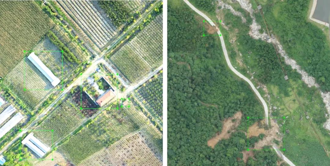
Based on the AI target detection technology, all the interested targets and scenes can be accurately found in the remote sensing image and their position and size can be quickly confirmed to accurately identify multiple natural resource targets and scene categories. By determining the location of key natural resource targets and their mutual relations, the technology can assist the land space usage controlling, ecological restoration, geological disaster prevention and law enforcement inspectors.

The recognition of building and landslide point based on AI+ remote sensing
2. The quantitative information extraction of natural resource based on AI+ remote sensing
Natural resource survey and monitoring requires a unified collection of the scope, quantity, quality and change of various natural resources. At the same time, the fine management of natural resources also requires a quick collection of the status of various categories of natural resources.
Based on AI image segmentation and classification technology, high-precision classification of high-resolution remote sensing images can be quickly realized, and the boundaries and quantitative indicators of various natural resource types can be quickly and automatically acquired, which can assist natural resource survey monitoring and evaluation, and realize the natural resources quantification and the fine management.

Building segmentation extraction of remote sensing image based on U-net
3. AI+ remote sensing change detection
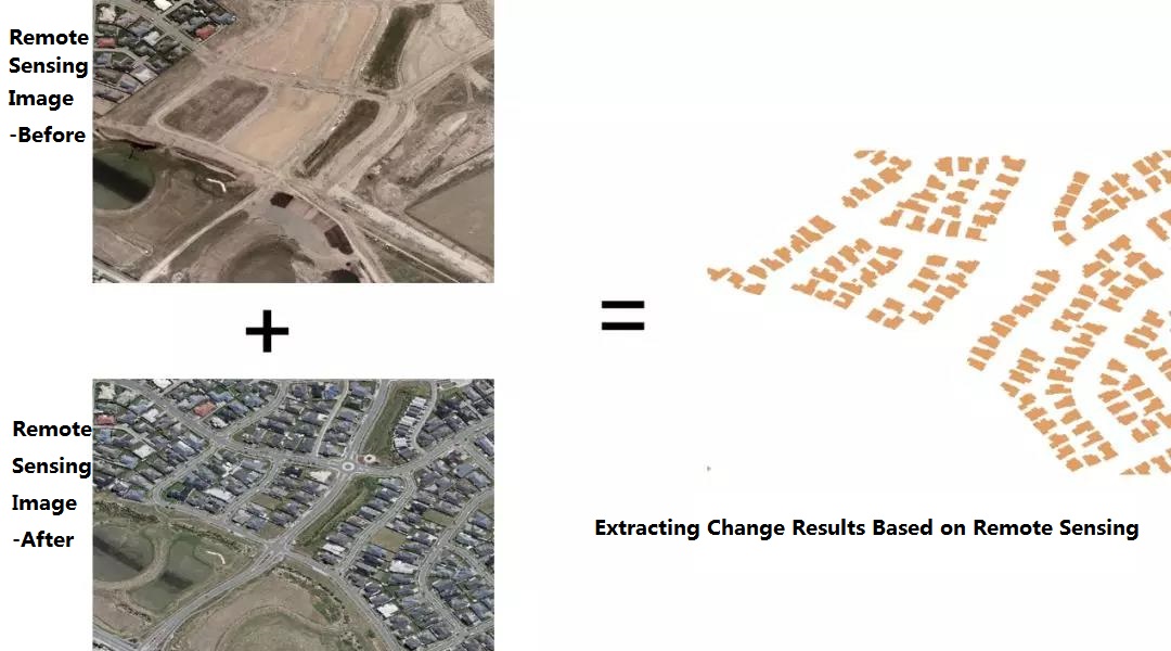
The natural resources supervision and farmland protection requirements the automatic comparison analysis, self-inspection and self-report, and results verification intelligent all-day monitor in the areas of large land use. In the past, the natural resources supervision mainly relied on remote sensing images based on different time phases which conducted by professional remote sensing monitoring experts with eyes to visually interpret them. Based on the changing AI image detection technology, it can quickly detect changes in natural resource categories within a certain area and a certain time period, and assist in the monitoring and assessment of land space planning, farmland protection, and law enforcement inspectors.

Extracting new buildings based on AI+ remote sensing
4. Multi-source remote sensing data processing based on AI
In addition to the remote sensing image target detection, image segmentation, classification and change detection technology based on AI, the multi-source remote sensing data processing and optimization technology can enrich the data resources and quality of all-day remote sensing monitoring, and further improve the comprehensive strength of natural resource management in all-day remote sensing monitoring assistance. It mainly includes:
(1) The 3D point cloud processing technology based on AI. It mainly includes the LiDAR point cloud registration technology based on convolutional neural network and LiDAR point cloud refinement classification technology. Comparing with image-based segmentation classification technology, it can further enhance the buildings and terrains and the accuracy of natural resource management.
(2) The remote sensing image quality optimization based on AI. It optimizes the existing data resources and improves the accuracy of image-based natural resource information interpretation through the super-resolution reconstruction and de-clouding of remote sensing image based on convolutional neural network.
(3) The hyperspectral image processing based on AI. The hyperspectral imagery can perfectly reflect the subtle features of various natural resource categories. Through the hyperspectral remote sensing image classification processing based on AI, the natural resource classification results can be achieved, as well as the assistance in fine management of natural resources.
AI GIS Make-up? See These Anime-style Maps>
What is AI GIS (Artificial Intelligence GIS) ?>
AI GIS + Remote Sensing Enhances the Ability of Natural Resources Monitoring>