The moving target positioning and tracking system for satellite ground station is a monitoring, pre-warning, and tracking platform based on remote sensing, positioning, mobile communication, geographic information and big data technolo…
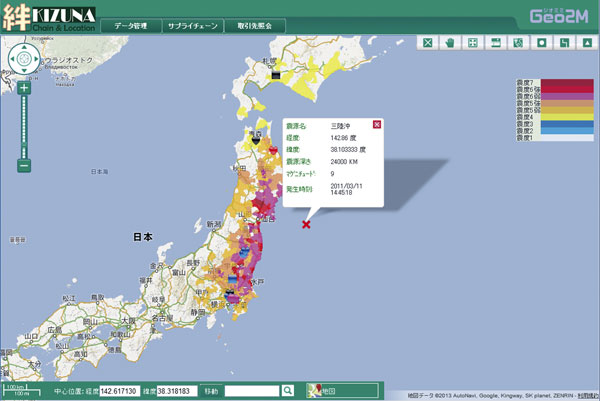
26 Jul,2019 big dataThe Japanese government has kept increasing its investment in disaster prevention since the big earthquake in 2011. Japan SuperMap began to focus on the system development to the GIS field related to disaster prevention and disaster prevention field relat…
08 Jul,2019 big dataCloud GISCurrently, GIS technology has been widely used in building information management, urban information management, such as grid system, public?information system, etc. Based on the GIS technology, the public information and management information of co…
01 Jul,2019 BIM+GISThe Smart Engineering Supervision Platform utilizes BIM, GIS, Internet of Things, big data, intelligence, mobile communication, ERP and other key technologies to integrate project management, video management, Internet of Things platform, big data platfor…
28 Jun,2019 BIM+GISAs a cloud GIS web client development platform of SuperMap, SuperMap iClient JavaScript introduces a Vue component library. The MVVM model (Model-View-ViewModel) is used in the architecture design, and it is also compatible with other frameworks, fo…
27 Jun,2019 iclientCloud GISThrough Integrating CloudGIS into the supply chain management, using the spatial data management and analysis, as well as the graphical display function, the production and sales processes of the transportation, warehousing, loading and unloading, deliver…
26 Jun,2019 Cloud GISiclientPipeline data is the basic information of urban construction and development. In the process of urban planning, designing, construction and management, the complete and accurate pipeline information is?indispensable for the efficient works and …
24 Jun,2019 3D GISBuilding the Comprehensive Geological Survey Information SystemSuperMap makes full use of big data technology, GIS technology, computer network technology and 3D visualization technology to realize the integration of the geological survey results, a…
21 Jun,2019 China 3D GIS