Traffic engineering construction, especially massive traffic engineering construction, covers fields of planning, design, construction, operation and maintenance and others. The 3D GIS is an important foundation for building comprehensive digitalization of transportation facilities. First, it can provide the capability to construct a full-element scene of a 3D transportation facility; secondly, in a full-element 3D scene, it can provide convenient analysis and display technology for planning and design based on BIM data; also, it can integrate with BIM and IoT (Internet of Things) to provide construction site and construction process with detailed management capabilities for construction, and more intelligent and convenient analysis and management capabilities for operation and maintenance.
Constructing full-element base of transportation facilities based on 3D GIS
The basis of smart transportation construction is the comprehensive digitization of transportation facilities, as well as the results of the digitization of transportation facilities, which must be a 3D full-element space base for 3D transportation facilities that can be presented, calculated, and managed. The full-element base of the transportation facility space is to construct refined facility model object data according to the transportation facility business needs, including transportation facility 2D vector and image data, transportation equipment facility 3D model data, transportation facility surrounding environment 2D, 3D data, etc. . It can not only carry the traditional traffic construction, management, maintenance and other services, but also can be taken as the application basis of new business directions such as traffic facility monitoring and operation big data mining.
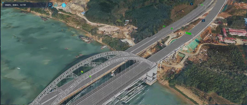
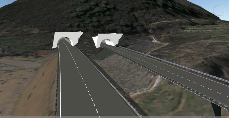
Based on new surveying and mapping technology and through new data from BIM modeling, oblique photogrammetry, point cloud acquisition, etc., a 3D base of refined transportation facilities can be constructed. Also, by overlaying video information, traffic dynamic status information, IoT device status information, weather, disasters and environmental information, a set of full-elements base of supporting the management, operation and maintenance of transportation facilities can be built.
SuperMap GIS software supports multi-source heterogeneous 3D data integration. It can fuse traffic design BIM models with terrain data, oblique photogrammetry data, point cloud data and other 3D data, and superimpose 2D spatial data of remote sensing images and environmental data of geological surveys, meteorology, geological surveys, etc. It can build a 3D full-element base with diverse sources, rich information, and comprehensive functions for transportation facility management.
In full-element 3D scenes, SuperMap 2D and 3D GIS technology supports operations such as presentation, comprehensive query, and overlay analysis of various 2D and 3D transportation facility objects, providing rich application methods for transportation facility management.
BIM+GIS transportation facilities planning and design
Construction companies in industry generally use BIM technology for design in massive engineering projects. when combined the BIM design data results with GIS multi-source data presentation and analysis capabilities, it can provide users with analysis and calculation capabilities and intuitive design achievement presentation capabilities during the design phase.
SuperMap GIS can provides designers with detailed 3D spatial analysis capabilities during the design process, and supports the rapid import of BIM design models into the GIS software platform. Through the mosaic of BIM data and terrain data, the road model can be combined with high precision accurate terrain to achieve the direct display of the road model on the ground. Also, it can extract the construction boundary range of the BIM model data, and superimpose the extraction results with the terrain data, which can accurately calculate the area boundary in the design plan and the land, population and other information in the statistical design plan in real time. It provides designers with convenient and fast route selection analysis capabilities, and assist the design unit in rational route selection.
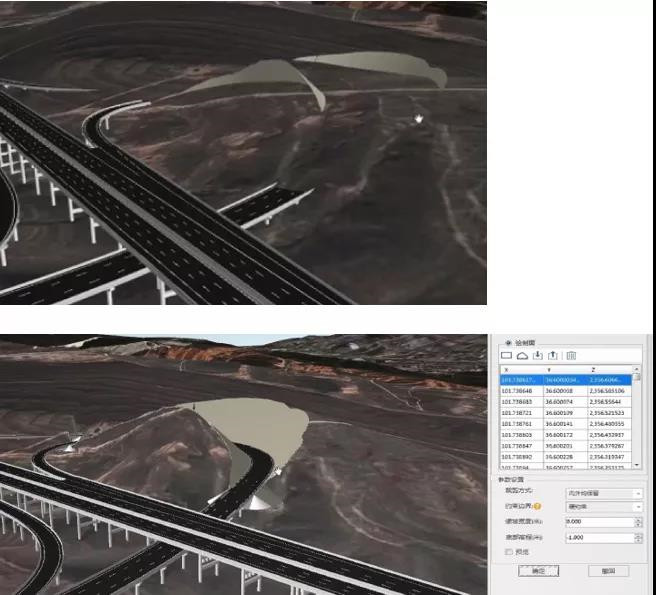
When the final design plan is determined, the BIM model can be imported into the GIS platform and superimposed with the environmental data such as terrain, image, and oblique, which can display the design plan for the construction companies. SuperMap GIS supports comprehensive scene optimization and service release of multi-source heterogeneous data. The design plan can be provided to relevant parties for online browsing and query, and 3D scenes can also be browsed through the mobile phone.
3D GIS technology assists smart construction of transportation facilities
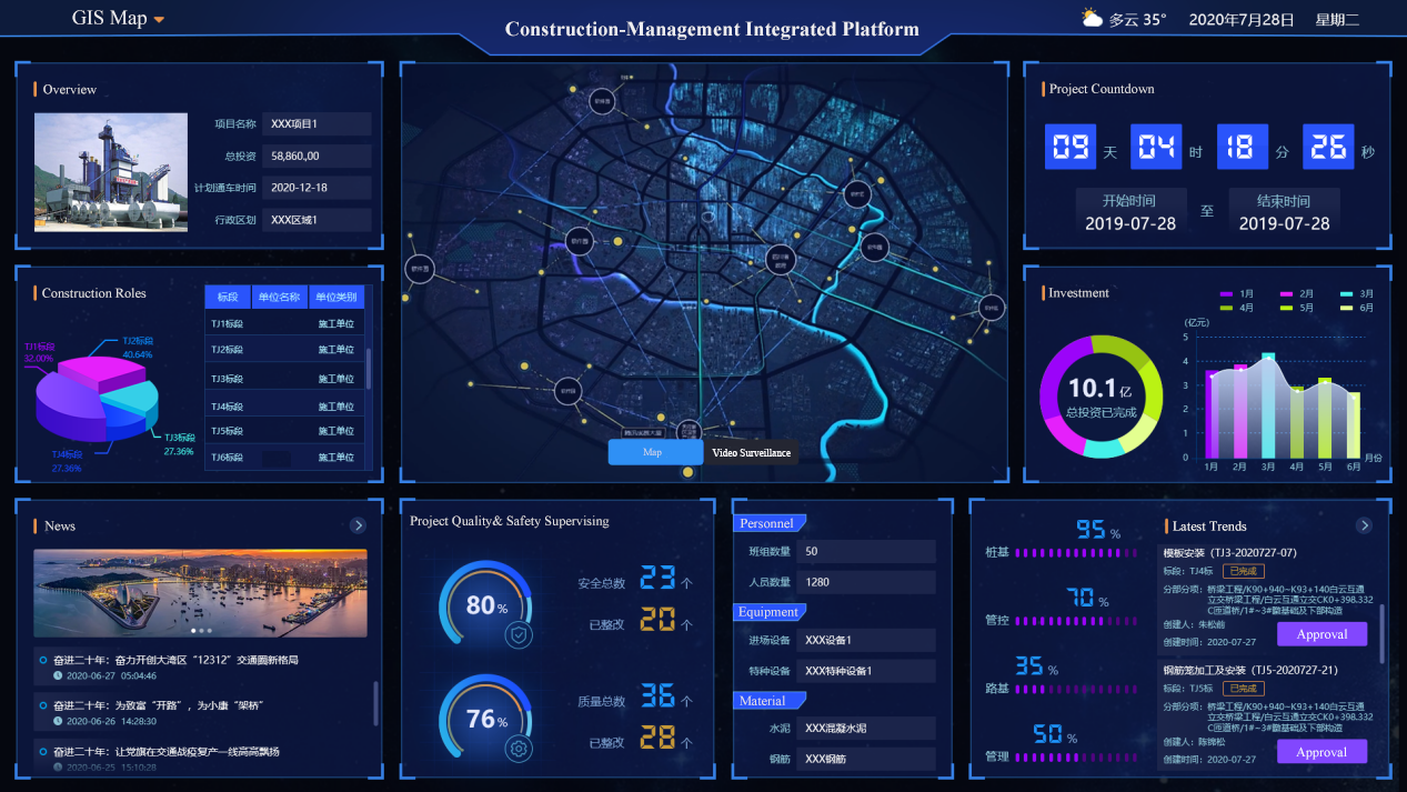
Smart construction is the main trend of transportation construction. Based on BIM data, by superimposing construction environment data and real-time dynamic data on the construction site, a dynamic virtual construction environment can be built on the SuperMap GIS 3D basic software platform. In 3D environment, the complex construction process information can be associated with the refined traffic objects in the BIM model to achieve refined management of the transportation construction process. Also, the construction process dynamic supervision can be realized based on IoT real-time data, construction process progress data and 3D object results.
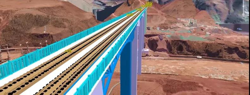
BIM model data in transportation massive engineering projects can usually achieve component-level accuracy. SuperMap GIS supports massive and refined model object loading display and analysis calculations. It can associate huge and complex engineering construction data with construction objects. All construction drawings, plans, supervision process data, material supply data, etc. can be bound to specific facility components in BIM data. In a 3D GIS scene, the construction information query, statistics, and visual rendering can be realized.
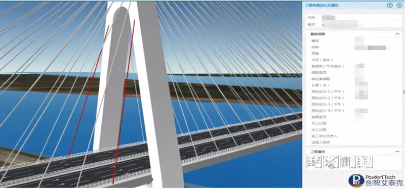
SuperMap GIS supports dynamic rendering of BIM models. By combining BIM construction with project progress information, the entire project model can be rendered and displayed according to different construction schedules, thereby assisting users to intuitively understand the overall project progress, and through the progress animation, the dynamically display of construction progress can be conducted within a certain period.
3D GIS supports the online operation and maintenance of transportation facilities
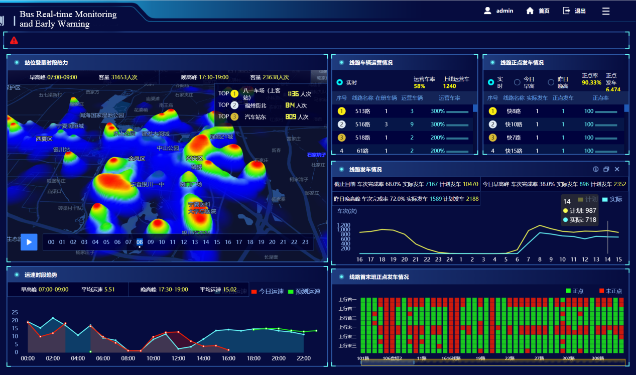
For the construction of massive transportation projects, efficient and intelligent maintenance management is an important task to ensure the continuous operation of transportation facilities. The transportation facility maintenance based on 3D GIS can manage the supervision and operation files of each transportation facility component, and realize the dynamic presentation and comprehensive analysis of the transportation facility maintenance work. SuperMap GIS has the capability of massive 3D data management, calculation and presentation. It can centrally and uniformly manage multiple maintenance sections and even the entire line components, laying the foundation for comprehensive analysis and decision-making and information mining of facility maintenance.

SuperMap GIS provides excellent 3D scene optimization and release capabilities, and can support the online release of 3D applications for the maintenance and operation of massive transportation facilities. Maintenance personnel can load 3D scenes directly through the network, query and analyze facilities information and conduct dynamically rendering as needed.
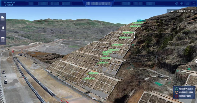
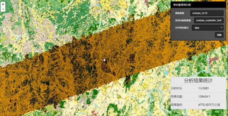
With the help of SuperMap GIS multi-source data integration capabilities, various types of detection information and BIM models can be analyzed and displayed in 3D scenes, and the status of transportation facilities can be accurately analyzed through 3D spatial position relationships to predict the impact of various types of disaster information on transportation.
New 3D GIS Technology in Underground Water Management>
2D and 3D GIS in Natural Resources Management>
New 3D GIS Technology Supports the Construction of "Digital Twins" in Transportation>