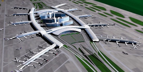
Guangzhou Baiyun International Airport was the world’s 13th-busiest airport by passenger traffic, with 65.8 million passengers handled (statistics in 2017) and over 210 destinations around the world. On April 26, 2018, the opening of the T2 Terminal of Baiyun Airport brought the passenger flow and throughput of the airport to a new high within a short period, which signified higher requirements for the informatization of the airport management.
The construction and application of EGIS (Engineering Geographic Information System) in Baiyun Airport has strengthened the role of GIS in intelligent operation and maintenance, bringing a brand-new fine management mode.
Publishing and sharing of online service
One update, multiple benefits
Baiyun Airport was faced with a series of difficulties such as multiple data resources, scattered storage, numerous management departments, and insufficient information exchange since its birth, which resulted in the various airport departments’ being unable to obtain standardized data.
The construction of the Public Service Platform of Engineering Geographic Information was the core of EGIS. Based on integrating airport basic geographic data and engineering map data, the unified standard spatial data was provided for departments and applications in the form of service sharing and publishing through ESB (Enterprise Service Bus). Through this bottom-up data update mode, a single data update may benefit the multiple.
Unified airport geographic information standard
Manage geographic data on “One Map”
The information management department of the airport has been troubled by disorganized storage format, different standards, scattered storage, and late update of geographic data, and the information barrier and disorganized format have become major obstacles for informatization. The system unified the geographic information standard, processed and stored all kinds of original data, managed data of overground and underground, indoor and outdoor on “One Map”, broke the data barrier, established a way of timely unified update of data, and provided a unified model for the daily maintenance of airport geographic data.
Visualization of file&map
Life-cycle management of the project
SuperMap GIS technology was used to collect, sort out and display all kinds of engineering data generated during the engineering life cycle, conduct data cleaning, sorting, conversion and loading, build an engineering drawing file management system to meet the needs of the airport engineering data process management, delivery and acceptance, and file handover and track and manage the whole process of design documents, construction documents, and completion documents.
Overground and underground integrated management
Intelligent decision-making of planning and construction
Integrated 2D/3D technology could visualize the comprehensive pipeline network of the airport. It provided real and accurate network information and supports quick queries, statistics, positioning, auxiliary decision-making, etc. It could be reliable evidence for the construction as well as the daily management, network maintenance, statistics analysis, planning, and decision-making after the construction, to form comprehensive centralized management and distributed application network information system. It could provide a basis for the visualization of airport construction and planning, and avert pipeline network failures caused by building.
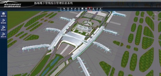
Underground pipeline management information system in the airport
Closed-loop inspection
Fine management of road surface
In the Airfield Pavement Management System, through the mobile-web business closed-loop procedure, it supported the background monitoring and mobile terminal networking and the offline access for on-site inspection and maintenance record, which have reduced the time errot of the inspection and maintenance, improved the informatization of pavement management of the airport and thus forms a powerful airport road surface decision support system.
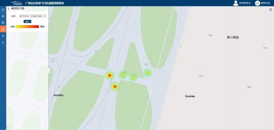
Thermal analysis diagram of road surface damage in airfield area
Indoor and outdoor visualization
One-stop management of facility operation and maintenance
The system integrated indoor and outdoor modeling of the terminal, carried out fine positioning and monitoring of facilities and equipment in the terminal, and built a platform for visualization of production and operation data of the terminal. It could manage the resources in the whole terminal by layers, enabling managers to accurately understand the layout, construction, and maintenance status of the overall facilities. It provided a unified visual "one-stop" operation and maintenance management platform for airport personnel, which enhanced the security of airport production and operation, and provided a visual basis for daily inspection and emergency repair.
The EGIS project has saved a lot of money for the operation and information management of Baiyun Airport. EGIS integrated airport business operation data, provided visual application management scenarios for airport production and operation management, connected the communication link between front-line service departments and senior leaders for decision-making, and reduced enterprise management costs. In addition, the project promoted the construction of an integrated 2D/3D model and the application of information systems in the civil aviation airport industry, enhancing the brand value and demonstration effect of the management mode of Baiyun Airport in civil aviation industry.
At the same time, EGIS unified the airport's geographic information data standards, which has standardized the airport's application access in GIS information services.