Based on SuperMap GIS, the partner company has developed a comprehensive project management system. The system realizes the integration and application of the 3D geographic information of the project area, the BIM model of the project, and various data in the project management process.
(1) The integration of BIM model and construction position
In order to realize the effective combination of the BIM model and each business system in the overall system, it is necessary to integrate each component in the BIM model and the construction position. Through the establishment of the position coding system, the construction position can be associated with the BIM model, and the BIM model can be combined with the progress, measurement and quality inspection.
(2) The integration of BIM model and construction progress
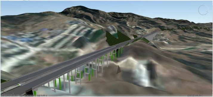
According to the comprehensive platform progress controlling function, each tender construction section reports the daily progress on the project management system every day It will be automatically updated to the BIM model according to the completed part of the engineering project in the daily report. Also, when browsing the BIM model, the completed parts will be performed in different colors to realize the function of understanding the project progress through the BIM model.
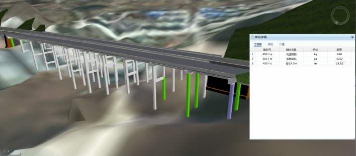
(3) The integration of BIM model, engineering quantity and measurement payment business data
After the association of BIM model and construction position of the system, the BIM model can be used to view the engineering quantity bills, measured and unmeasured list data of each component.
(4) The integration of BIM model and on-site quality inspection data
During the construction process, the quality inspection data and on-site construction photos of key process can be collected on the PC and mobile phone APP. After the on-site quality inspection data is collected, it can be browsed on the corresponding components of the BIM model.
(5) The integration of BIM model, tunnel construction equipment and personnel location data
In the tunnel construction process, in order to improve the construction safety management, the mechanical equipment and personnel inside the tunnel can be posited, and the system can automatically collect the information of the mechanical equipment and personnel positions to display on the BIM model.
(6) The integration of BIM model and on-site surveillance videos
By integrating the surveillance videos that installed on the construction site into the system, it can set the monitoring location of the construction site in the scenario of GIS+BIM model to realize the integration of the BIM and the live surveillance videos. So, when browsing the BIM model, the live monitoring video can be accessed.
Through the 3D GIS platform, the project effectively combines the BIM model of the expressway and various business data in the project management process, and associates the traditional business data with the 3D model to achieve the visual management.
BIM+GIS in Building Information Management>
BIM+GIS Application in Life Cycle Digital Management of Yalong River Hydropower>