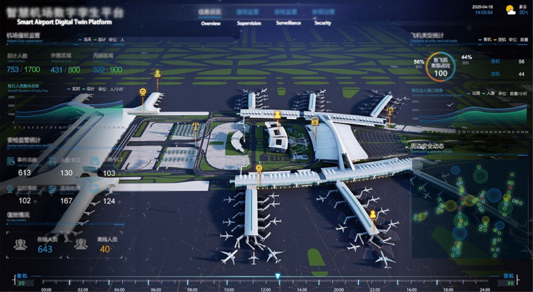
SuperMap shows its latest achievements of the Smart Airport “Digital Twin” platform on the recently held national “Internet + Smart Airport” summit. The flight area surveillance system, apron vehicle tracking system and VR immersive experience system attracted the attention of many partners to the SuperMap booth. This article will discuss the SuperMap smart airport “digital twin” platform and application results.
1. Smart Airport “Digital Twin”
SuperMap relies on the basic GIS platform to create a safe and efficient “digital twin” application platform for smart airports.
The platform integrates and shares engineering drawings and geographic information data based on BIM+GIS+loT technology, and incorporates new technologies such as the Internet of Things, cloud computing, artificial intelligence, mobile technology, 2D and 3D integration, and new concepts of engineering management and airport management. It provides basic services for various smart applications in the airport. The platform recreates the information management process of the smart airport, realizes the map application of multi-data fusion in the air, ground, underground, and indoors of the airport, and guarantees the safety and efficiency of the airport operation.
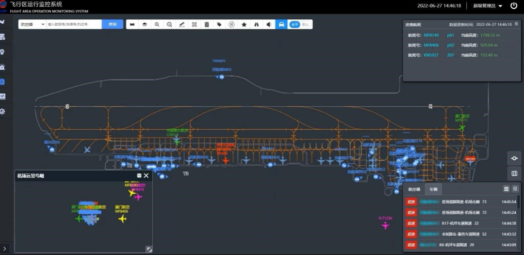
2. Surveillance of the flight area
Through data collection and spatial visualization technology, the system combines air traffic control data, travel information data, airport production data and various system data in the flight area, and uses the management mode of “One map” to realize the automatic monitoring of work status of departments and terminals in the flight area. Through the operation event push and information visualization technology, it can help managers fully grasp the operation situation of each area and improve the comprehensive dispatching ability of the flight area. The systematic information coordination can enhance the level of collaboration between the flight area management department, ground handling, air traffic control and AOC. Automated monitoring and reminders based on flight zone operation rules reduce the risk of production and operation in the flight zone and improve the level of production and operation guarantee in the flight zone.
3. Apron vehicles tracking management system
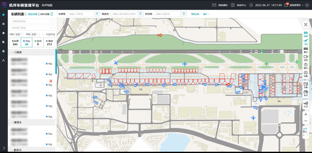
The apron vehicle tracking management system uses the map service provided by the airport geographic information system and the location service provided by the high-precision integrated positioning system to locate, monitor, track and manage vehicles with high-precision differential GPS equipment.
The system is based on the management of apron vehicles and drivers in the flight area and focuses on vehicle resource management, vehicle access management, vehicle violation management, vehicle location management, driver management, vehicle safety rules and control management. The platform displays the running status of the entire apron vehicle. The system assists airport vehicle safety, monitoring and dispatch management, and provides technical support for the management of vehicles and drivers in the flight area.
4. VR Immersive Experience
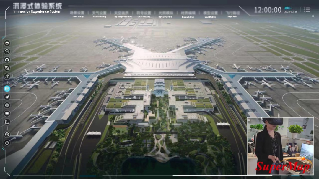
The VR immersive experience system is a result of a metaverse project bid by SuperMap. At present, the project has completed the first phase of the project as planned and has been highly recognized and appreciated by airport users.
The VR immersive experience system adopts the new integrated innovation technology roadmap of BIM+GIS+VR, and imports the large-scale airport BIM data of forwarding design into the VR scene. It helps designers and decision-making teams to accurately verify the design effect and experience the functions of the future airport in an immersive manner.
Author: Chang Zhigang; Ma Yan, SuperMap Application Business Group