Yueyang government started a grid social management service system comprising of public service system construction, social grid management, community self-governance. Yueyang government realized public service convenience, detailed grid management, self-…
06 Mar,20181. 3D GIS? 3D desktop, componentSkyline analysis function optimized, setting observer diameter supported, exporting 360 degree skyline analysis results as circle 2D line. Model translation function added.? 3D WebGL Aspect and slope analysis function add……
01 Mar,2018 3D GISThese are the effect pictures of communication signals overlaying with 3D models generated by SuperMap GIS?Signal Density Distribution Displaying in Color and Isoline?Signal Density Distribution Displaying in Color
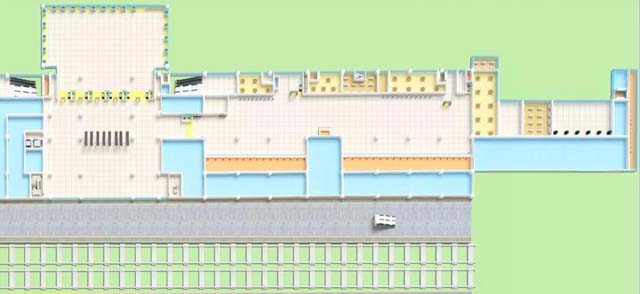
28 Feb,2018 3D GISIn the recent years, railway department advances using technology to create a better trip environment. In order to help railway clients find the service facilities in station, China Railway Network Software Company hosted the construction of intelligent n…
26 Feb,2018 big dataSCQA Makes Data Insights Have Rules to FollowInternet makes getting information easier and easier, however, it brings less independent thinking. Data itself is the quantification of facts, data insight is with the help of data analysis. Data insight is fo…
11 Feb,2018 Cloud GISSuperMap Online will explore the geographic intelligence with you with the brand-new front-page.Geographic coding service, national basic data coverage upgradeData insight, enhancement on spatial analysis function, more convenient work platform1. Newly ad…
11 Feb,2018 big dataSmart is one of new features of modern city. As the capital city of China, Beijing has made accomplishments in smart city construction, making city transform from ‘digital’ to ‘smart’, solving old problems of city management.Xicheng District of Beijin…
09 Feb,2018 2D+3Dbig dataProject BackgroundSatellite vessel tracking big data project is based on vessel location, merging with global coastal and satellite big data information service platform, which aims at improving the safety of vessel and vessel production and can be used f…
05 Feb,2018 big data