Overview

It is a mobile GIS software development platform that supports 2D&3D application development, online/offline applications and offline applications.

Features

AR map

  • Supports AREngine, including model loading, AR maps, map gestures, etc.
  • Newly supports objects in gif, obj, fbx and other formats on AR map.
  • Newly supports accurate linkage between map and AR real scene.
  • Measurement for AR stereo, area, and angle.
  • AR stereo collection of doors and windows for AR interior design and planning.
  • Supports intelligent analysis based on PyTorch model to improve analysis accuracy.

High-precision collection

  • New outdoor positioning methods improves positioning accuracy.
  • Regularization of vector data sets supports rapid regularization of graphics.

Mobile 3D

  • Newly supports AR on iOS.
  • 3D modeling based on LIDAR.

Navigation map

  • Optimizes indoor navigation path planning.
  • Optimizes AR real-scene navigation, customize route display and guide interface.

Map display

  • Newly supports custom XYZ map service loading.
  • New dynamic layer unified style.
  • Newly supports multi-threaded pre-caching for Rest online service.
  • Optimizes map browsing performance, and supports track layer symbols, layered rendering of primitives.

Overview

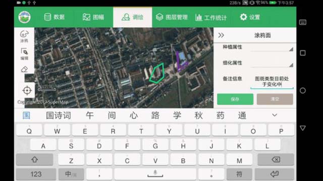
It is a full-function mobile GIS APP and developed based on SuperMap iMobile for RN framework. It supports AR, map, acquisition, 3D, cartography, plotting, analysis, navigation, cloud-terminal integrated data interaction and expansion development. It is convenient for users to process, analyze and collect GIS data on the mobile terminals. It can be found and downloaded from App Store and other Android stores.

Features

Custom extension

  • Novice guide can help users get started quickly.
  • Supports horizontal and vertical UI interfaces, and realizes multi-size device adaptation.
  • Available in Chinese, English, Japanese, French, Arabic, Turkish, etc.
  • Supports small program extension plug-in development, and realizes plug-in download and deployment management without restarting.
  • Supports full-featured interface customization such as title, icon and homepage customization.

AR map

  • Supports adding points of interest, vectors, special effects, models, 3D to make AR maps.
  • Predefined 3D pipelines, terrain, flags, airplanes, earth and other models.
  • Predefined special effects such as lightning, winter snow, autumn leaves, spring flowers, etc.
  • New AR layer management supports add, delete, rename and other operations.
  • Newly supports AR map layer style modification, including transparency, border color and outline width setting.
  • Supports object editing, including points of interest, vector objects, model objects size, displacement, angle, etc.

Map browsing

  • Optimizes the basemap switching.The basemap can be switched on the home page of the function module.
  • Improves multi-source data import, and supports common GIS formats importing.
  • Improves the labeling function, and supports editing labeling objects and modifying object styles.

AR mapping

  • New function of automatic capture.
  • New function of tactile vibration feedback. It is automatically triggered when adding or capturing nodes.
  • Improves AR measurement and provides length, height, area, volume, and angle measurement.
  • Improves the position calibration, and supports calibration method through pictures positioning.
  • Improves AR mapping, and supports drawing points, lines, and areas based on feature point clouds.

3D browsing

  • New demonstration data, including oblique photography, 3D terrain, fine models, etc.
  • Optimize online scene browsing.
  • Supports distance and area measurement.

Field collection

  • Supports satellite dotting, manual dotting and gesture drawing.
  • Support the collection of graphics, attributes, multimedia, etc.
  • Templated collection, custom collection template.
  • Provide graphics editing tools such as cutting, merging, erasing, etc.

Navigation collection

  • Optimizes the positioning frequency of external devices, and supports distance positioning and time positioning.
  • Improves indoor and outdoor integrated navigation.
  • Provides indoor and outdoor path analysis and navigation.
  • Provides outdoor road network collection and constructs road network in real time.

Thematic mapping

  • Supports more than 20 thematic types such as area map, ladder map, rose map, etc.
  • Provides dozens of color schemes for thematic maps.
  • Supports automatic generation of legend, and adds title for thematic map.

Data processing

  • New function of data registration supports four algorithms: linear registration, quadratic polynomial registration, rectangular registration and offset registration.
  • New function of projection conversion supports 6 conversion methods, and can copy or reset the coordinate system.
  • Supports 10 kinds of data analysis methods, such as path analysis, connectivity analysis, etc.

AR analysis

  • Provides four analysis methods, including target recognition, vehicle collection, etc.
  • Analysis results are automatically displayed on map.
  • Supports extended custom training model.

Coordination of cloud and terminal

  • Improves online collaboration, and publishes multimedia data as a service in the form of annotated layers.
  • Improves group services, and supports group members to download and update service data in collaborative tasks.
  • Available to share account with SuperMap Online or SuperMap iPortal.

Overview

It is a lightweight mobile GIS APP based on AR, and developed based on the SuperMap iMobile for RN framework. It supports AR real-scene measurement, AR data collection, AR map production, AR positioning, navigation, analysis, etc. It can be used for indoor and outdoor high-precision data collection, AR real-scene browsing, navigation , etc. It can be found and downloaded from App Store and other Android stores.

Features

AR measurement

  • Supports real scene measurement, including height, length, angle measurement.
  • Supports area measurement of polygon, rectangle and circle.
  • Supports volume measurement of cuboid and cylinder.
  • Supports automatic capture of existing object nodes.
  • Provides tactile vibration feedback when capturing and adding nodes.

AR mapping

  • Supports indoor high-precision data collection based on feature point clouds.
  • The collected data complies with industry standards and can be directly used for indoor and outdoor GIS related applications.
  • Provides dot style and track style for point, line and surface collection.
  • Provides real-time preview in 2D small map on AR mapping interface.
  • Provides location calibration: automatic positioning, map selection, QR code scan positioning.

AR map

  • Supports full-process AR map making, including creation, editing, cloud, terminal sharing and multi-terminal browsing.
  • Supports adding vector text, special effects, models and 3D objects.
  • Supports adding POI, including pictures, videos, web pages, etc.
  • Supports style modification of AR map layers.
  • Supports editing through gesture.
  • Supports adding animation effects to model objects.

AR navigation

  • Support real-scene navigation through user-owned network data and POI data.
  • Supports indoor navigation based on visual inertial navigation positioning.
  • Provides a variety of AR guide signs.
  • Supports POI search by inputting target point.
  • Provides direction compass for real-time guidance.
  • Provides a 2D small map to view the overall path information.

Data management

  • Supports 2D map and AR map management.
  • Supports local data, symbols, scenes and dynamic models management.
  • Supports sharing local data, maps, and symbols to Online.
  • Supports downloading and importing the data in the Online account.

Support

Demo Code
Technical Docs
Training Files