Overview

It is a full-featured mobile GIS SDK that supports 2D&3D application development, online/offline applications and offline applications.

Features

AR map

  • Supports integration of AR and multiple geospatial data, such as vector, model, image, terrain, effects, POI, web page, etc.
  • New AR effects of flower falling, leaves falling, dark clouds, raining, snowing, as well as custom effects.
  • New sand table capability of AR, which is suitable for scenic spots, real estate, battlefield scenes, and supports gesture operation of sand table.
  • New pipeline capability of AR supports browsing, interaction, attribute query and automatic picking based on location.
  • Provides GIS point coordinate acquisition, trajectory acquisition, point cloud collection with centimeter level.
  • New AR measurement function supports area, distance and height measurement.
  • Improves AR mapping to suitable for indoor and outdoor vector and point cloud data acquisition.
  • New visual location based on feature point cloud and icon location based on image recognition.
  • Supports target segmentation, 3D recognition, target detection and target classification.
  • Supports recognition of pose, gesture, foot and other objects.
  • Supports the recognition of license plate and vehicle number, color, type and other information to realize low-speed continuous recognition of real-time license plate.

Coordination of cloud and terminal

  • Supports access to SuperMap Online and SuperMap iPortal account for multi-terminal group management.
  • Supports the management of user group, message and task data, and supports the delivery of files, services and resources.
  • Supports multiple terminal data acquisition and synchronous update, and supports real time display of SuperMap iPortal dashboard.

Data collection

  • Supports GNSS collection, manual drawing, etc.
  • New trajectory acquisition filter optimizes trajectory smoothing effect.
  • Supports topological editing methods such as merging, splitting, and breaking based on line and polygon objects.
  • Supports multimedia information collection such as sound, image, video, etc.

3D scenes

  • New rolling shutter function.
  • New height measurement function.
  • New function of loading plane TIN and image.
  • New function of grid terrain loading optimizes online terrain image download performance.
  • Optimizes loading point cloud data, and supports layered color setting.

Data management

  • Supports local vector format: udb, shp, mif, dwg, dxf, kml, kmz, etc.
  • Supports local raster format: tiff, GeoTiff, img, sit, sci, jpg, png, bmp, etc.
  • Supports 3D data: fine model, oblique photogrammetry, point cloud, terrain, BIM, etc.
  • Supports online map: Google, OSM, OGC, SuperMap Online, etc.
  • Supports MVT, GL map tiles and TPK.

Map display

  • Newly supports Google HD tile service and custom HD tile service.
  • Optimizes vector performance, and realizes the output of hundreds of thousands of spots in seconds.

Navigation map

  • Supports park navigation, enhances map data collection, production process, and realizes customized navigation guidance, road network model, etc.
  • Supports AR real scene navigation, and optimizes the ground effect of the guide arrow.

Overview

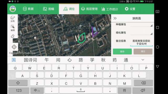
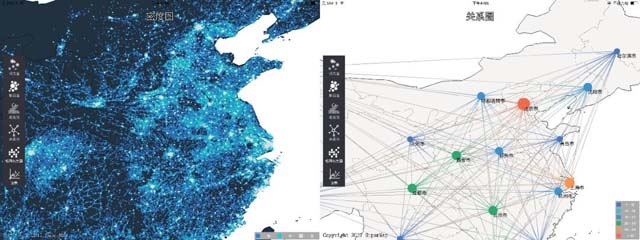
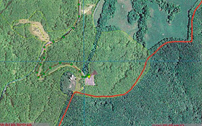
It is a full-function mobile GIS APP based on SuperMap iMobile development. It supports finger mapping, templating data collection, data analysis, 3D data display, indoor and outdoor integrated navigation, target recognition and detection, and also supports the extension of development and can be used to for rapid customization development of industrial application system.

Features

Custom extension

  • APP homepage upgrades, supports horizontal and vertical UI interfaces, and realizes multi-size device adaptation.
  • Available in Chinese, English, Japanese, French, Arabic, Turkish, etc.
  • Supports small program extension plug-in development, and realizes plug-in download and deployment management without restarting.
  • Supports full-featured interface customization such as title, icon and homepage customization.

AR map

  • New AR sand table function supports overlaying multiple model data such as buildings, routes, and annotations into real scene.
  • New AR measurement function of area, distance and height.
  • Improves AR collection and supports saving/canceling collection process.

Map browsing

  • New function of voice operation and map searching.
  • Improves multi-source data importing, including the format of tif, mif, shp, img, kml, kmz, gpx, etc.
  • Improves the labeling function, and supports editing labeling objects and modifying object styles.

3D scene

  • Newly supports WebP texture compression, which reduces resource usage by 70%
  • Supports accessing to multi-source 3D data, such as fine model, oblique photogrammetry, BIM, terrain and other .

Field collection

  • New function of custom collection template creation.
  • New function of template management supports element name, code and attribute setting.
  • Supports satellite dotting, manual dotting and gesture drawing.
  • Supports object editing operations such as merge and split.

Navigation collection

  • Provides outdoor road network collection function, and supports hand-painted and trajectory road network collection.
  • Improves the function of road network building.
  • Supports accessing to external positioning equipment.
  • Improves indoor and outdoor integrated navigation.

Thematic mapping

  • Supports more than 20 thematic types such as area map, ladder map, rose map, etc.
  • New custom color scheme for single values thematic map.
  • New custom segments of the segment thematic map.
  • Supports automatic generation of legend, and adds title for thematic map.

Data processing

  • New function of data registration supports four algorithms: linear registration, quadratic polynomial registration, rectangular registration and offset registration.
  • New function of projection conversion supports 6 conversion methods, and can copy or reset the coordinate system.
  • Supports 10 kinds of data analysis methods, such as path analysis, connectivity analysis, etc.

Coordination of cloud and terminal

  • New function of online collaboration supports friend collaboration, group collaboration.
  • New function of public data, which can provide users with downloadable public data.
  • Available to share account with SuperMap Online or SuperMap iPortal.

Support

Demo Code
Technical Docs
Training Files