Introduction
This article is an excerpt from an award-winning work of the SuperMap GIS Contest.
The Guangdong-Hong Kong-Macao Greater Bay Area is one of the urban agglomerations with the most developed economy, the highest population density and the highest degree of openness in China. At the same time, there are many ecological functional areas for water conservation, biodiversity protection and soil conservation in the Bay Area. However, relevant studies have shown that in the process of rapid urbanization, the ecological system function in this area has been seriously degraded, and the contradiction between people and land is prominent; the focus of the subsequent high-quality development of the Guangdong-Hong Kong-Macao Greater Bay Area is to seek a balance between economic development and ecological protection. Therefore, it is imminent to alleviate the conflict between man and land in the Bay Area, and the research on the spatial conflict between construction land and ecological land is of great significance.
This study measures and visualizes the spatial conflict in the Guangdong-Hong Kong-Macao Greater Bay Area from 2000 to 2020, analyzes its temporal and spatial changes, and explores the causes and internal laws of the changes; and according to different scenarios, the simulation forecast of the future land use and spatial pattern of the area was conducted.
From the perspective of ecosystem service trade-offs in the process of rapid urbanization, this study incorporates socioeconomic factors, urbanization expansion, and ecosystem service responses into the analysis and evaluation of spatial conflicts to analyze and study the temporal and spatial evolution characteristics of regional spatial conflicts. The model predicts and simulates the evolution of future land use patterns and spatial conflicts in the study area under different scenarios.
Overview of the research area
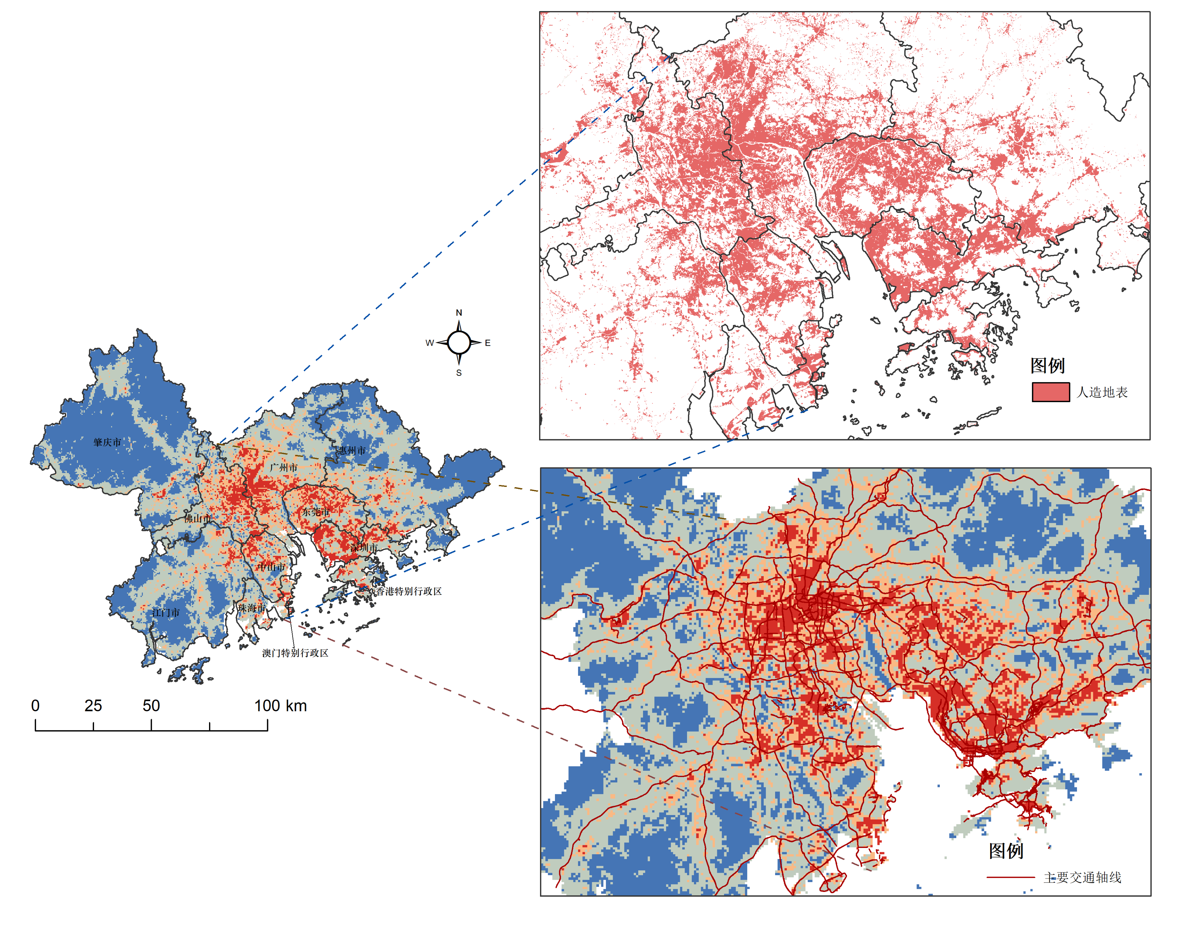
The Guangdong-Hong Kong-Macao Greater Bay Area is located in the coastal area of China, with a total area of 56,000 km².
Foundation data
In the specific analysis process, we import the raw data of land use, road network, administrative division, GDP, population density, DEM and temperature and precipitation involved in the research into SuperMap iDesktop, and store them as corresponding vectors (points, lines and planes) and raster data; and preprocessing, so that each dataset maintains the same spatial extent of the study area.
Analysis process
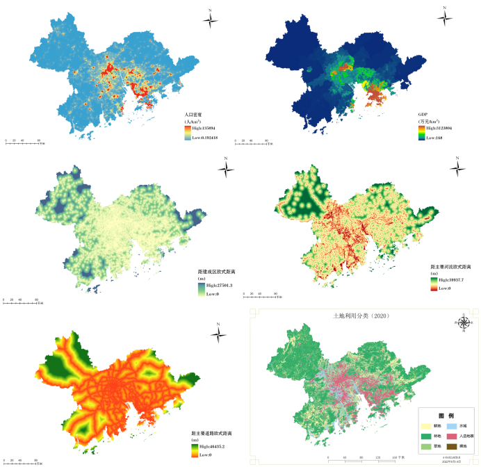
• Spatial conflict measure
We use the “generate distance grid” to complete the calculation of the exposure degree index, and use the grid algebra operation tool to complete the normalization of each index and the calculation of the final spatial conflict index; then normalize and segment with “geometric classification”. Space conflicts can be divided into four levels: stable and controllable, basically controllable, basically out of control and seriously out of control.
Relation between spatial conflict intensity and land use types and main traffic axes
The results show that the spatial conflict in the study area is further strengthened with the development of urbanization. Although the overall situation is still controllable, the local conflict continues to expand. If it is not controlled, it may cause irreparable damage to the ecosystem in some regions.
• Scenario simulation forecast
We selected the required driving force factors, set up different constraint factor matrices, and ran the model in the GeoSOS-FLUS software; imported the generated TIFF files into SuperMap iDesktop for visualization, and obtained the predicted scenarios of the Guangdong-Hong Kong-Macao Greater Bay Area spatial pattern of land use in 2030.
FLUS model predicts the spatial pattern of land use in 2030 under different scenarios
Then, according to the previous method, the spatial conflict measures are calculated separately, and the spatial conflict pattern of the Guangdong-Hong Kong-Macao Greater Bay Area in 2030 is obtained under the three forecast scenarios. The results show that, compared with the natural development scenario, the spatial conflict intensity of land use under the cultivated land protection and ecological protection scenarios has decreased; further analysis shows that, compared with the natural development scenario and the cultivated land protection scenario, the spatial structure of land use in the Bay Area under the environmental protection is better.