General Introduction
Turkey 3D cadastral project is the first cadastral project that SuperMap formally participated in Europe. SuperMap developed a special vectorization tool for General Directorate of Land Registeration and Cadastre of Turkey, and established and optimized the workflow of conversion from 3D model to CityGML. It reduced the workload of manual processing, improved the efficiency of data processing, reduced human resources input, saved time and economic costs, and provided strong support and guarantee for Turkey to establish a national 3D cadastral database.
Background
Turkey has a strong industrial foundation. It is one of the world's emerging economies, and one of the fastest growing countries in the world. Turkey ranks 6th in the world in the ranking of house property price growth index in the fourth quarter of 2019. With the year-on-year house property price growth rate of 11.1%, Turkey becomes one of the best performing housing markets in the world. With the rapid economic development, the construction of residential, industrial and commercial facilities in major cities of Turkey is also proceeding rapidly. After years of practice, the Turkish cadastral registration system is considered as one of the most efficient systems. Many offices can complete house transaction registration within one day, but there are still many problems that need to be resolved.
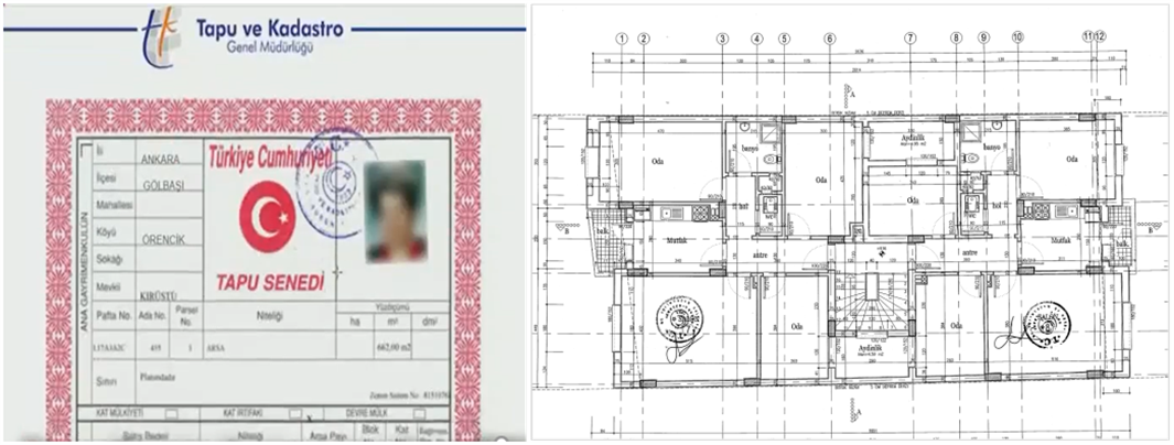
The biggest problem is that there are a large number of paper house registration and drawing data in the current cadastral information management, which is difficult to view the information of each house in the building in a 3D manner. It has been unable to meet the needs of digital and 3D cadastral management at this stage. Therefore, the cadastral management departments of Turkey hope to establish a 3D cadastral database and formulate standardized data standards, adopt the international general spatial data exchange format CityGML, and use 3D model to display the structure and house registration information of each building hierarchically, thereby improving the efficiency of cadastral management .
Overview
This project started at the end of 2019. It ustomized and developed a full-process cadastral data processing tool based on SuperMap iDesktop, which can quickly complete the batch cutting of drawing images, fast vectorization, batch registration and 3D modeling. The generated results include the detailed data of the internal and external walls, rooms, balconies, floors, doors and so on, so as to facilitate the fine 3D management in the later stage.
Meanwhile, SuperMap provided a complete solution of format conversion. Users can output the 3D model as OGC international standard spatial data exchange format CityGML through one click workflow, which is convenient for later data interaction and further application.
Highlights
1. Deep customized development to improve data processing efficiency
Under the support of desktop team from SuperMap Institution, SuperMap provided users with deep customized tools for developing data processing and vectorization based on SuperMap iDesktop. It reduced the repetitive operation and realized the efficient digitization of paper drawings.
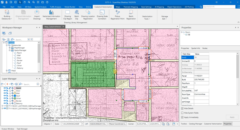
Cadastral vectorization interface of SuperMap iDesktop
Automatic data database building based on template
According to the user-specified name, data set type, coordinate system and other parameters, the workspace, data source, data set and coordinate system information are automatically created.
Batch cutting and registration
Based on the original drawing data of the house, the house drawings can be cut and registered in batches
Quick vectorization tool
In view of the unique housing structure shape and outline in this project, a customized drawing tool was developed to realize the one-click drawing of the wall. It reduced the number of mouse clicks for drawing, and improved the standardization of drawing vectors
Floor batch copy modeling
It supports floor batch copying and modeling, which can copy multiple houses of the same type in batches and complete 3D modeling
Template attribute entry
According to the needs of users, the template for the entry of room attribute information is customized, and the entry of attribute information can be quickly completed in the vectorization process at the same time, which can avoid the duplication of work.
Automatic data checking
Provides comprehensive data checking tools. Users can use this tool to set constraint conditions for attribute information and spatial information. It can automatically complete data checking and topology processing, and further ensure the accuracy and authenticity of the paper-based information to the digital information.
2. 2D & 3D integration technology ensures the quality of data production
Based on the 2D and 3D integration technology of SuperMap, the plane data can be rendered into a 3D effect for display in real time in the vectorization process, and the 2D data and the 3D model can also be associated and displayed without switching them, which is convenient for users to find errors in time in the vectorization process. It improves the accuracy of vectorization and ensures the quality of data production.
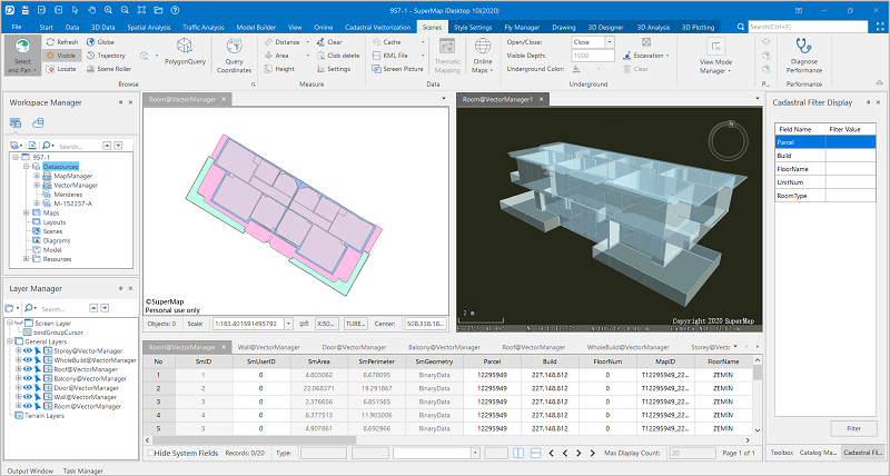
2D &3D linkage display
3. A complete data conversion process meets the requirements of international standard data exchange format
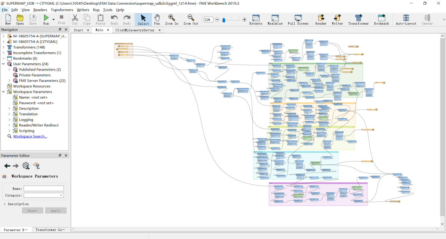
The General Directorate of Land Registeration and Cadastre of Turkey not only sets strict standards for the quality of data production, but also has higher requirements for the efficiency of data processing. The data standard needs to be based on the standard CityGML data structure, it also adds customized attribute information. In order to reduce the workload during processing, FME software was used for data conversion in this project. It established and optimized a one-key data conversion workflow based on MyFME plug-in, and realized the result of directly converting the 3D model data set into the CityGML format. Users do not need to care about the intermediate processing after inputting the source data, but can directly obtain the results that meet the requirements. It greatly simplifies the process of data conversion and improves the efficiency of data processing.
Data processing workflow:
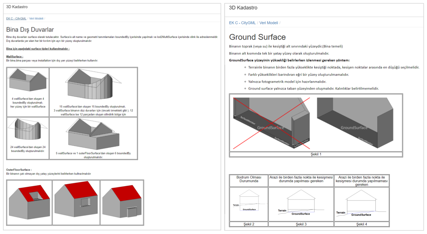
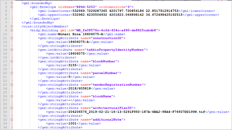
CityGML data structure:
CityGML data 3D model display:
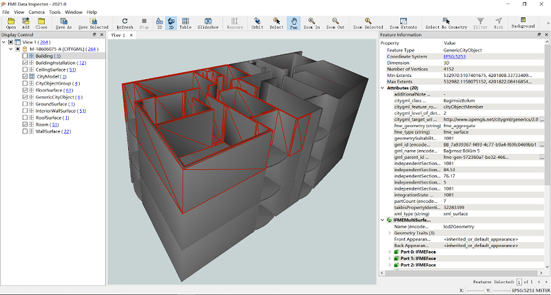
CityGML data 3D model display
4. The integration of multi-source 3D data provides a wealth of options for later applications
Based on the multi-source 3D data fusion capability of SuperMap and the SuperMap iClient 3D for WebGL product, the house 3D model data and the oblique photography modeling data can be superimposed and displayed on the WEB side, so as to achieve the effect of intuitive display as cadastral data. Meanwhile, the customized development can be carried out according to the needs of cadastral business, such as attribute information query, 3D spatial analysis and other functions, which enriches the application of data.
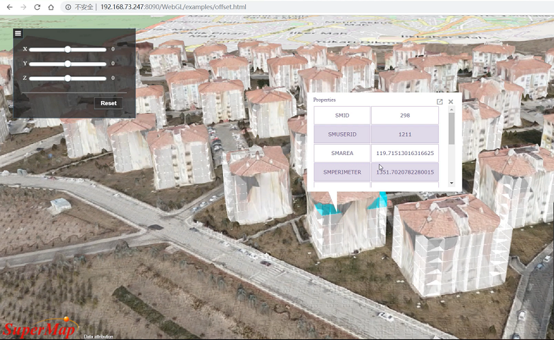
The effect of superimposed display of model and oblique photography
Significance
According to the Turkish 3D cadastral data standard, the project optimized the vectorization and modeling process of 3D cadastral data, and innovated the way of data conversion. The technology of batch data processing and modeling reduces labor costs and optimizes resource utilization. The improvement from 2D to 3D realizes refined and 3D management of cadastral, improves the level and efficiency of Turkish cadastral management, and also enriches the data types of geographic databases, which creates a solid foundation for the later construction of 3D digital cities.
Conclusion
Turkey 3D cadastral project is the first cadastral project that SuperMap formally participated in Europe. It fully meets the international general data exchange format standards and is another successful practice of SuperMap on the road to internationalization. It marks the landing of SuperMap in the European market, and at the same time provides valuable experience and a solid foundation for the further development of the European market in the future.
With the continuous development of 3D GIS technology and the continuous in-depth integration of new-generation information technologies such as big data, AI(artificial intelligence), 5G and blockchain, there will be more in-depth research and application in 3D cadastre, real estate registration management, and land space planning. SuperMap will continue to be committed to the promotion of the international market, and will provide users from all over the world with more choices, so that Chinese technology can be more used in overseas market.
Remarks:CityGML
CityGML is an open standardised data model and exchange format to store digital 3D models of cities and landscapes. It is the extendible international standard for spatial data exchange issued by the Open Geospatial Consortium (OGC) and the ISO TC211. It defines ways to describe most of the common 3D features and objects found in cities (such as buildings, roads, rivers, bridges, vegetation and city furniture) and the relationships between them. It also defines different standard levels of detail (LoDs) for the 3D objects, which allows the representation of objects for different applications and purposes, such as simulations, urban data mining, facility management, and thematic inquiries.