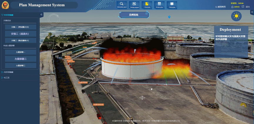
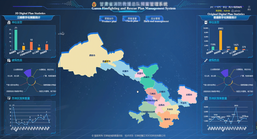
Gansu Province 3D Digital Plan Platform for Rescue and Firefighting, based on the geospatial database and adopting the method of 3D display, proposes a new rescue and firefighting drill method - online drilling. Integrating ordinary digital plans and 3D digital plans, it can effectively store and manage practical information in normal times, and quickly obtain and release disposal plans during real firefighting.
Based on the new generation of 3D GIS technology of SuperMap, the platform can implement the firefighting application featuring 2D&3D integration, such as multi-source heterogeneous data fusion, symbolic 3D modeling, flame particle 3D simulation, spatial information query and analysis calculation, etc.

3D digital plan platform for rescue and firefighting
Give full play to the technical value of 2D and 3D integrated GIS technology
• 2D&3D integrated visualization of the plan
The traditional rescue plan can only describe the situation of key units through text, on-site photos and building structure drawings, etc., and cannot directly display the specific information of the disaster site, while the 3D visualization rescue plan can more intuitively and comprehensively reflect the actual situation of the disaster site. In the process of project construction, due to the diverse sources of 3D construction data, there are problems such as inconsistent formats.
To solve these problems, the project combines the SuperMap multi-source heterogeneous data fusion and matching technology, and takes the 2D&3D integrated GIS technology system as the basic framework to perform scene fusion and matching on multi-source data such as oblique photographic models, fine models, vectors, and terrain. It breaks through the technical bottleneck of large-scale 3D data transmission and analysis under B/S, greatly reduces the construction, management and operation and maintenance costs of the 3D GIS application system, improves the utilization efficiency of spatial data, and better restores the disaster scene. It has these features:
1. Build fine models for the internal and external components of key units, and quickly access relevant information in the event of a disaster, such as internal structure information such as fire hydrants, fire shutter doors, smoke exhaust vents, and attack passages;
2. Carry out 3D modeling of oblique photography for the surrounding environment, restore the real environment of the scene, and provide an auxiliary basis for the analysis and deduction of the disaster situation;
3. Combined with the Internet of Things technology, the real-time status of the fire protection facilities, video surveillance information, etc., are organically integrated with the 3D model and panoramic photos, and the monitoring information can be displayed quickly and accurately, buying time for rescue and firefighting.
• Realistic 3D visual and efficient display of the rescue scene, simulating firefighting
In the simulation and deduction, it is impossible to grasp the detailed information of the scene only by relying on the digital plan. In this project, combined with SuperMap's lightweight 3D client development platform SuperMap iClient3D for WebGL, it applies advanced HTML5 WebGL technology, supports cross-platform, adapts to multiple types of browsers, supports hardware-accelerated 3D rendering technology, and does not need to install plug-ins. The 3D service can be browsed without installing plugins, greatly improving the access experience of displaying real 3D models and laser scanning fine models on the web terminal. It can help people quickly understand the relevant resources such as surface terrain, buildings, roads, water sources, etc.
• The 3D symbol library enables the rapid construction of 3D plan components
There are many information elements involved in the preparation of the project plan, including disaster description, force deployment, weather, surrounding environment, etc. It is not easy to quickly build such a scene. In the system, component-based functions are used to preset element models that are often used in various types of fire protection plans, such as fire vehicles, officers and soldiers, flames, smoke, plot symbols, etc., and can be added to the 3D scene by dragging and dropping, which can simply and quickly restore the text description in the traditional card-type plan to restore the scene of intuitive and visualized disaster information and force deployment.
In the project, SuperMap GIS provides a 2D&3D integrated symbol solution. In a 3D scene, by using 3D point, line, and fill symbols for 2D vector data, the trouble of duplicating data can be avoided, making the ground objects more intuitive. 3D symbolization modeling technology, including 3D line symbolization technology, 3D pipeline symbolization technology, water surface filling symbolization technology, etc., effectively assists the rapid construction of 3D plan scenarios.

3D pre-plan component-based rapid construction
To produce the plan rapidly and conveniently, the system provides a comprehensive and diverse 3D model for disaster setting, force mobilization and deployment, and can arrange firefighters according to factors such as the location of the fire, the nature of the combustion, and the surrounding environment.

Quickly make plans with the help of firefighting facility models
• Realistic particle effect effectively assists in the teaching of firefighting and rescue
In addition to providing various types of models, the system also presets a variety of particle effects, including water, fire, smoke, rain, snow, etc. Each particle effect has a variety of expressions according to different usage scenarios, helping fire rescue personnel simulate the situation of the disaster site under different weather conditions, such as adding information such as wind force, wind direction, temperature, humidity, etc. that affect the fire situation.

Realistic effect of flame particle
• Accurately mark the location of each fire hydrant to familiarize firefighters with the fire scene in advance
In the firefighting and rescue battle, water is the bullet of the rescuers. How can the rescuers quickly find the indoor and outdoor fire hydrants and other related fire-fighting facilities after they arrive at the scene?
Based on the map, the system displays the distribution of fire-fighting facilities in key areas. Through memory test training, the rescuers' grasp of the fire-fighting facilities, fire-fighting control and surrounding facilities of key units is strengthened, to quickly control and deal with the disaster after arriving at the scene.
• Professional practice evaluation model to optimize the use of firefighting resources
The system conducts mathematical modeling of some important logic relationships and data, such as the firefighting estimation function, which can quickly calculate the consumption of related rescue materials such as foam or water. The functions of logistics support, social linkage, and the expert list can reasonably evaluate, analyze, and deploy firefighting and rescue forces.
• Integrate and retrieve surrounding resources to quickly deploy rescue forces
The spatial analysis ability of GIS is the embodiment of data application value. 3D GIS needs to have strong analysis ability from visualization tools to practicality. SuperMap's new generation of 3D GIS mainly supports 3D space operation, 3D spatial relation judgment, 3D space analysis, dimensionality reduction calculation, 3D network analysis and 3D measurement calculation.
Based on the spatial analysis capability of GIS, the system comprehensively restores information such as the geographical location of the disaster site, adjacent buildings, rescue forces and rescue materials in the form of "one map". In normal simulation and actual combat, firefighters can quickly understand the battlefield environment and formulate rescue plans.
For example, in actual firefighting, through the spatial analysis and query capabilities of the system, people can quickly understand the information of surrounding buildings and firefighting facilities of key units, as well as the distribution of firefighting force within 30 minutes to 180 minutes, to set accurate firefighting force support, scientific offensive and retreat routes, and more appropriate plans for arranging firefighters will help eliminate disasters.
• Comprehensive analysis of big data, making decision analysis more scientific
The big data comprehensive analysis module mainly controls the key points and difficulties of fire protection work in Gansu Province on a macro scale, and provides scientific decision-making support for future work arrangements.
SuperMap GIS provides powerful and comprehensive analysis operators, including spatial big data operators, vector-oriented and raster-oriented classic GIS analysis operators (with distributed reconstruction), and analysis operators for stream data processing and distributed spatial machine learning analysis operators, etc., to assist in the monitoring and early warning of accident-prone areas; distribution analysis of key units, firefighting forces, and rescue materials; assessment and evaluation of firefighting work in various regions, and statistical analysis of disaster frequency and trends, historical data retrospective.

Big data spatial analysis decision
3D restoration of the big fire scene and the whole process
• Technical reproduction of fire scene
Taking a customer as an example, there are more than 6,000 key units within its jurisdiction, with a very large number and various types, such as underground engineering (supermarkets, civil air defense), high-rise buildings (department stores), office buildings), petrochemicals (petroleum storage tank areas, chemical plants), etc. It is necessary to accurately and quickly locate the area under its jurisdiction, and truly reflect the disaster situation and rescue forces of the on-site units, and arrange firefighters.
Based on SuperMap GIS software, how to manage a large number of key units with the complex model structure on “one map”, display and apply them uniformly? We provide the following technical solutions:
1. Optimize the 3D model, reduce triangular surfaces as much as possible, and optimize the texture;
2. With the help of SuperMap 3D data lightweight technology and multi-level of detail technology (LOD), the scene performance is improved;
3. Ensure authority control, and only display 3D models within the scope of authority to low-authority users.
• Full-process reproduction of the fire scene
In a real fire scene, the color, combustion method, and flow direction of the flame are complex and diverse, and various flame models need to be made to deal with various fire conditions. SuperMap provides particle effects such as flames, rain and snow, fireworks, explosions, etc. Using the particle editor to customize particle effects and particle motion methods, a variety of beautiful and practical particles such as water column and cherry blossom rain can be created, and users can specify where the rain and snow to fall. It is widely used in weather simulation, emergency drills, safety protection, and effects such as floodlights, rolling shutters, tail lines, and scanning lines.
Taking a fire in an oil storage tank as an example, when a fire occurs, a ring-shaped flame is usually formed along the sealing ring around the storage tank. The general point-shaped flame cannot restore the scene situation. For this reason, we specially made a ring-shaped flame model. And when a fire occurs in an oil tank, it is often accompanied by oil leakage, and a flowing flame will be formed according to the direction of the oil leakage. When making a flowing fire in the Solutions
Tags:2D+3D