SuperMap logo
  • Products

    What is GIS

    About SuperMap GIS

    Technology System

    • Big Data GIS
    • New RS Software
    • New 3D GIS
    • Geospatial AI
    • Distributed GIS
    • Cross Platform GIS

    SuperMap GIS 2024 New!!

    • Cloud GIS Server
    • Edge GIS Server
    • Terminal GIS for Desktop
    • Terminal GIS for Components
    • Terminal GIS for Web
    • Terminal GIS for Mobile

    Previous Versions

    • SuperMap GIS 2023
    • SuperMap GIS 11i(2022)
    • SuperMap GIS 10i(2021)
    • SuperMap GIS 10i(2020)
    • SuperMap GIS 10i
    • SuperMap GIS 9D(2019)
  • Solutions

    Smart City

    Natural Resource

    Land Management

    Facility Management

    Public Safety

    Natural Disasters

    Transportation

    Water Conservancy

    BIM+GIS

  • Stories
    • Articles
    • News
    • Events
    • Magazines
  • Support
    • Download & Online Help
    • Online Demonstration
    • Ask & Answer
    • Discover SuperMap GIS
    • Trial License
  • About
    • lntroduction
    • Careers
    • Contacts
    • Suggestions
 
  • English
  • 中文
  • Español
  • Français
  • ภาษาไทย
  • русский
  • Türkçe
  • Português
  • 日本語
  • 한국어
  • Indonesian
  • عربي
Articles

Articles

  • Home
  • Stories
  • Articles
  • Sparks in AR+GIS

    AR (Augmented Reality) is an interactive experience of a real-world environment where the objects that reside in the real world are "augmented" by computer-generated perceptual information, sometimes across multiple sensory modalities, including…

    11 Jan,2019 ARBIM+GIS
    Sparks in AR+GIS
  • Multi-source Data Integrated Technology in 3D Scene

    The development of 3D technology in oblique photogrammetry and laser point cloud reduced the difficulty and cost of data collecting, but increased the frequency of data upgrading. BIM technology provides meticulous 3D model, and makes the 3D management be…

    09 Jan,2019 3D GISOblique PhotogrammetryBIM+GIS
    Multi-source Data Integrated Technology in 3D Scene
  • A New Geographic Design Engine - SuperMap 3D Designer

    SuperMap 3D Designer is a geographic design engine based on the new 3D GIS technology. It provides precise interfacing, various multi-source heterogeneous data (both ground and underground) processing, 3D spatial query and analysis, etc. SuperMap 3D Desig…
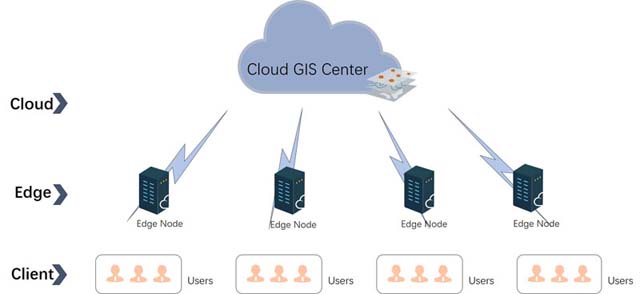
    07 Jan,2019 3D GIS
    A New Geographic Design Engine - SuperMap 3D Designer
  • SuperMap GIS Technology - Edge Computing

    Edge computing is an important supplementary technology of cloud GIS. It manages GIS resources more flexibly in a high efficient and low cost way. SuperMap iEdge 9D(2019) is such an edge GIS server.Front-end ProxyDue to the internet delay and the limitati…

    03 Jan,2019 Cloud GIS
    SuperMap GIS Technology - Edge Computing
  • How to Load 3D Data on Mobile

    There are?always problems from users about how to load 3D data on?mobile. The following parts?will introduce how to load 3D data based on SuperMap iMobile through two different methods of online and offline.Online LoadingOnline loading is t…

    07 Aug,2018 3D GISimobile
    How to Load 3D Data on Mobile
  • Big Data Distributed Cluster Environment Deployment

    As the era of big data is coming, it is more and more difficult for the traditional GIS analysis tools to meet the analysis needs of large volume spatial data. SuperMap iServer 9D provides the distributed cluster architecture of geographic information ser…
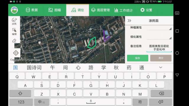
    30 Jul,2018 big data
    Big Data Distributed Cluster Environment Deployment
  • Automatic Speech Recognition (ASR) of mobile GIS

    Usually, we need to input a large number of text information when we use mobile applications. The traditional typing modes are keyboard input and handwriting input. However, the low input speed of those two modes brings a great impact on the work efficien…

    25 Jul,2018 imobile
    Automatic Speech Recognition (ASR) of mobile GIS
  • SuperMap BIM + GIS Integration Technology and Solutions

    BIM technology keeps developing and being applied in a lot of industries, such as planning, real state, architecture, water, electricity, transportation and so on. This is a new challenge to the 3D GIS. The 3D spatial information needs to make a closed lo…

    23 Jul,2018 BIM+GIS
    SuperMap BIM + GIS Integration Technology and Solutions
<<< < 29 30 31 32 33 > >>>

SuperMap GIS

  • Cloud GIS Server
  • Edge GIS Server
  • Terminal GIS for Desktop
  • Terminal GIS for Components
  • Terminal GIS for Web
  • Terminal GIS for Mobile

Stories

  • Articles
  • News
  • Magazines
  • Events

Support

  • Download & Online Help
  • Online Demonstration
  • FAQ
  • Demo Code
  • Technical Docs
  • Training Files
  • Videos
  • Trial License

Events

  • [list:pagetitle] [list:targetlink]
  • {/zzz:list}

About

  • lntroduction
  • Careers
  • Contacts
  • Suggestions

Follow Us

  • LinkedIn
  • Facebook
  • Twitter
  • Instagram
  • YouTube
© 1997-2023 SuperMap Software Co., Ltd.
  • Sitemap
  • | Privacy