Overview

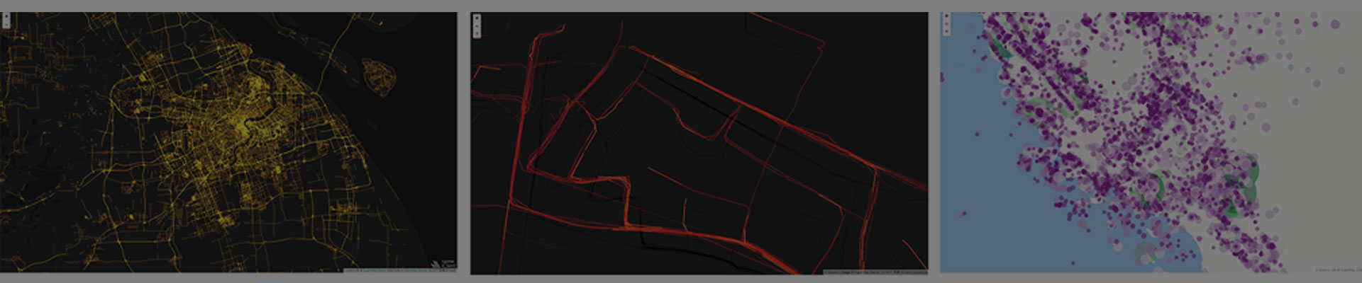
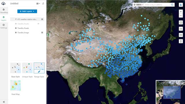
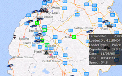
The cloud GIS web client development platform is based on the modern Web technology. It is the unified Javascript client for the SuperMap cloud GIS and online GIS platform products.

Features

Component development

  • Supports component development under Vue framework, including map component, rich geographic visualization components, chart component and basic GIS component, etc.
  • MVVM mode (model view ViewModel) is adopted in architecture design, and other frameworks are compatible, such as Angular and native H5 development.
  • More than 100 sets of themes are built in the component, and the theme styles of all components can be switched with one click.

Big data visualization

  • Provides unified API and visualization for distributed analysis service and data flow of SuperMap iServer.
  • Supports various temporal and static visualization effects: scatter plots, thermograms, honeycomb plots, trajectory plots, O-D plots, flow diagrams, 3D architectural drawings, wind maps, etc.

Image

  • New image service: API.
  • Supports the browsing and retrieval of image service data.

Integrates the commonly used maps and chart libraries

  • Map development library supports: Leaflet, OpenLayers, MapboxGL-JS, iClient Classic.
  • Chart development library supports: ECharts, D3, MapV, DECK.GL.

Vector tiles

  • Supports MVT and standard coordinate systems like Web Mercator, WGS84, CGCS2000 and local coordinate system.
  • Supports interaction and style configuration, including query, selection, highlight, etc.

Client computing

  • Integrates turf.js, and supports client computing like geospatial, topology, equivalence, measurement, etc.
  • Client can achieve high performance analysis and calculation without interaction with server.

Overview

It is a 3D client development platform based on WebGL technology, which can be used to build 3D GIS applications with plug-ins free, cross-operating systems and cross-browser.

Features

Full functions

  • Supports high-performance loading and display of massive, multi-source, and heterogeneous data such as images, terrain, maps, vectors, manual modeling data, underground pipelines, tilted photography models, BIM, laser point clouds, and 3D field data.
  • Supports efficient rendering of massive real-time dynamic data.
  • Supports 3D geospatial analysis and analysis result output: through-view analysis, visual field analysis, skyline analysis, sunshine analysis, profile analysis, openness analysis, etc.
  • New function of elevation analysis.
  • Fully supports PBR.
  • Supports animation effect setting on S3M layers.
  • New model drawer push-pull effect (based on the normal direction of the pickup position).
  • New visual expression of voxel grid with spatio-temporal information. Supports sectioning, polygon clipping, gradient transparency filtering, zooming along the Z axis, obtaining isosurfaces, etc.
  • New measurement function with model vertex capture supports height measurement with reference line.
  • Improves the effect of 3D model border lines.
  • New rain and snow effects.
  • Newly Support five to nine split screen modes.
  • Newly supports memory management in S3M layers.
  • Optimizes local cache (IndexedDB) data read and write performance, and improves data loading efficiency.
  • New Vue3.0 component and SuperMap iEarth based on Vue component.

Data security

  • Supports the loading of terrain image service encrypted by cache stream.
  • Supports terrain, image, S3M layer, WMTs, body object data to set custom request header.

Support

Technical Docs
Training Files