Overview

Cloud GIS application server is based on high-performance cross platform GIS kernel. It provides full-featured GIS service publishing, management and aggregation functions, and provides multi-level expansion and development.

It provides powerful web services for geospatial big data, GeoAI and 3D to support massive vector/raster data "slice-free" publishing.

It deeply integrates microservice and docker layout, provides a variety of SDKs to build cloud native GIS system with micro service architecture.

Features

Flexible deployment, elastic scaling, high availability

  • Supports classic deployment modes such as single machine multi-process and multi-machine cluster, with high performance and high availability.
  • Supports microservice architecture and docker deployment mode, convenient deployment, fine-grained scaling, and resource saving.
  • Provides full-featured GIS microservices such as maps, data, distributed analysis, 3D, machine learning, streaming data, etc.
  • Provides fine-grained microservice mirroring, built-in native compilation technology, with faster startup and less resource usage.

Multi-level distributed storage, computing and processing

  • Supports node dynamic accessing, intelligent scaling and automatic synchronization between nodes.
  • Supports MPP distributed relational database, distributed NoSQL database and distributed file system.
  • Supports distributed computing platforms of Spark, Hadoop YARN,etc.
  • Provides distributed geospatial analysis, distributed data processing, streaming data real time processing, etc.

All-round extensible GIS service publishing and aggregation

  • Provides 2D and 3D spatial data publish, management, editing, analysis and processing.
  • Provides domain geospatial service extension mechanism, including service capability, interface, security, cluster, etc.
  • Supports aggregation SuperMap platform services, tripartite services, OGC services and online map services.
  • New image service capabilities, supports for the rapid publish of large-scale image (raster) data, and supports STAC-API specifications.

Accessing, processing and efficient publishing of geospatial big data

  • Provides distributed analysis service, and supports distributed processing and geospatial analysis of vector and raster data.
  • Provides streaming data service, and supports real time accessing and distributed processing of streaming data with 100 thousands/sec level.
  • Provides processing automation services and supports more than 600 analysis tools including vector, raster, 3D, GeoAI, and spatio-temporal big data.
  • Supports “slice free” publishing technology of vector and raster data.

3D data publishing, editing and analysis

  • Provides data publishing of 3D point, line, polygon, body, field, as well as oblique photogrammetry model, BIM and point cloud.
  • Provides online editing capability of 3D data to edit attribute and geospatial information.
  • Provides geospatial computing of 3D Intersection, union and difference, and measurement and calculation of volume and surface area.
  • Provides 3D geospatial analysis of sunshine, skyline, visualization, 3D buffer, etc.

GeoAI supports the whole process

  • Provides machine learning services, and supports GeoAI analysis operator of target detection, ground object classification, object extraction, binary classification, decision tree regression,etc.
  • Provides geospatial data science service to make online interactive geospatial data scientific exploration based on Notebook.
  • Provides geospatial data science service for work flow of covering sample production, model training, model evaluation, model reasoning, etc.

Blockchain geospatial data publishing and editing

  • Supports blockchain geospatial data published as map services, data services and data history services.
  • Provides dynamic mapping and geospatial query capability.
  • Provides editing and history tracing for multiple users.
  • New blockchain certificate management capabilities.

Web map printing

  • Supports GeoPDF which is printed as A0/A1 map.
  • Supports secondary editing of geospatial/text information in printing results.
  • Provides extensible layout template for transportation, land, etc.

Solutions

Overview

It is a cloud GIS portal platform for integrating, searching, sharing and managing GIS resources. SuperMap iPortal has advanced technology and capabilities, such as quick website building without code, multi-source heterogeneous services registration, and multi-source service authority control, etc.

SuperMap iPortal provides plentiful Web applications, including thematic mapping, GeoAI image analysis, distributed geospatial analysis, 3D visualization, dashboard creation and display.

As the user center, resource center and application center of cloud & terminal integration GIS platform, the cloud portal site of GIS can be quickly built.

Features

MapDashboard WebApp

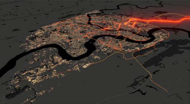
Geological data visualization dashboard application can display the analysis based on location in the way of intuitive and interactive visualization, which can help decision making, visualization trend analysis, real-time monitoring and spatio-temporal playback analysis.

  • New templates of smart city, smart park, etc.
  • Supports dark and light skin switching.
  • New navigation bar and map drill component.
  • New materials of static and dynamic picture.
  • Supports to open local coordinate system map in a plane coordinate system.
  • The layer list component can display the layer attribute.

MapStudio(beta) WebApp

GIS applications running on the Web can provide GIS portal users with convenient and efficient GIS capabilities. It is used for rapid mapping, spatial analysis, and spatial data editing on the Web. At the same time, based on vector tile rendering technology, it provides a smooth map browsing experience.

  • Supports unique value thematic maps, range thematic maps and heat maps making.
  • Supports overlay analysis, grid summary and area summary analysis.
  • Supports spatial data editing.
  • Supports vector mapping of published maps.
  • Supports 3D map making.

DataInsights WebApp

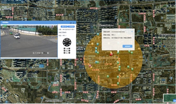
Through interactive operation, geospatial data analysis Web application can realize online visualization and analysis of geospatial data, integrate SuperMap iServer distributed analysis and data science service, and support extension to help users dig the value of geospatial data.

DataViz WebApp

It is a lightweight and high-efficient data visualization application, providing thematic map making, streaming data visualization and map printing, which can realize Web map making and sharing.

GIS portal building

  • Provides multiple common portal function modules, and supports custom development to quickly build exclusive GIS portal.
  • New visual customization UI components such as carousel chart, multi-line Footer, etc.
  • Provides full code customization capabilities, and supports in-depth customization for portal builders.

GIS service integration

  • Improves GIS service publishing capabilities, and supports publishing vector tile services, traffic network analysis services, WFS services, etc.
  • Supports access of SuperMap iServer image services.
  • Supports online visual preview of GIS service.

Solutions

Overview

It is a comprehensive GIS operation and maintenance management platform which can be used for application service management, infrastructure management, and big data management. It provides cloud native GIS solutions based on Kubernetes to one-click create, manage and maintenance big data, AI and 3D GIS system based on cloud native technology.

It can monitor multiple GIS data storage, computing, service nodes or other Web sites, and monitor the occupancy of hardware resources, map access hotspots, node health and other indicators to achieve integrated operation and maintenance management of GIS system.

Features

Convenient sites building

  • Provides one-click deployment of GIS systems and frequently-used databases.
  • Provides quick building of big data site.
  • Provides UI customization, grouping, and expands third-party industry application site.
  • Provides quick building of blockchain environment.
  • Provides Helm deployment.

Full featured monitoring capability

  • Provides monitoring of hardware resources occupancy and service resources utilization.
  • Supports statistical report.
  • Supports function of intelligent alarm.
  • Supports rule management of general monitoring and database monitoring.

Easy to use GIS microservice management

  • Realizes GIS microservice monitoring and elastic scaling and error recovery.
  • Provides service CPU adjustment and memory specification.
  • Provides service topology map of GIS site.
  • Supports rolling update of designated service.
  • New capability of GIS cloud site backup and recovery.
  • New capability of GIS site resource restriction.
  • New integrated service grid technology supports gray publish, access control, service measurement, and service tracking.

Support