
Ports are one of the important hubs of transportation. In recent years, with the development of "Internet Plus", China's port construction has also experienced digital, automated, and intelligent transformation and upgrading. In order to build Tianjin into a world-class smart port and green port, Tianjin Port (Group) Co., Ltd. (hereinafter referred to as "Tianjin Port") has joined forces with SuperMap, and built the Tianjin Port Group Port Geographic Information Middle Platform (hereinafter referred to as the "system") based on the application status and needs of Tianjin Port Group and its affiliated enterprises in geographic information systems to fully promote the construction of "Tianjin Smart Port" and improve the visualized management of space in various fields of the port.
Pain points in construction
• The lack of a unified standard specification system means that data resources cannot be effectively aggregated and integrated, resulting in difficulties in data docking and sharing between departments and units at all levels;
• Duplicate construction of basic data resources and functions results in a waste of resources and dissatisfies the needs of integration with modern emerging technologies;
Based on the status quo, Tianjin Port combined new technologies such as big data, cloud computing, and the Internet of Things and built a port geographical information middle platform, which realizes the integration, sharing and utilization of geographical information resources, and enables the rapid delivery of port business systems.
Technology Architecture
The system adopts a distributed and micro-service architecture to provide one-stop integrated services such as geographic information data, platform capabilities, and application integration for the entire territory, achieving intensive management of geographic information resources and capabilities, forming an operating model of platform plus application, which would further support the smart port construction.
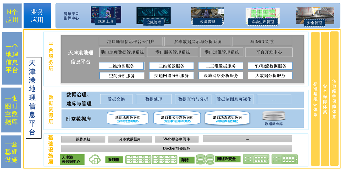
Platform architecture diagram
Accomplishments
A spatio-temporal big data service system to achieve data standardization and centralized management
The system fully absorbs and utilizes standards at all levels, and based on the status quo, an internal standard specification system for spatio-temporal data with port’s characteristics has been formed. At the same time, thematic geographical data resources in various business fields are gradually integrated to form a multi-dimensional spatio-temporal data resource pool.
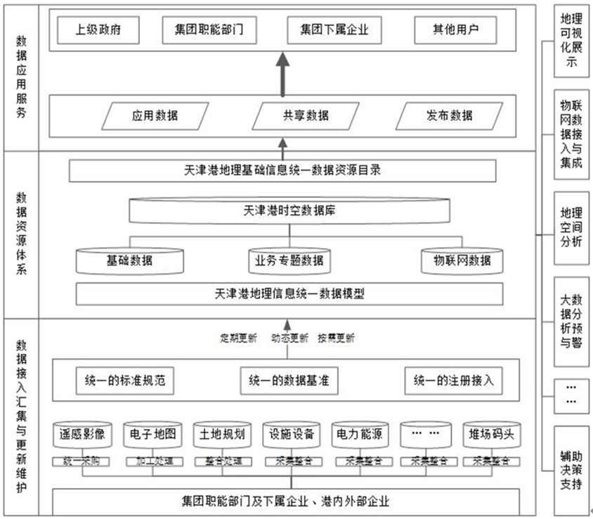
Data resource system
The Tianjin Port Geographical Information Middle Platform with comprehensive abilities of display, management and use
To meet the needs of port business informatization, SuperMap built the Tianjin Port Geographical Information Middle Platform based on GIS, big data, cloud computing and other technologies. The six subsystems jointly support the comprehensive capabilities of the platform to display, manage and build applications.
Display: The multi-dimensional data display and big data analysis functions can realize real-time dynamic display of massive multi-dimensional data with beautiful and dazzling effects.
The multi-dimensional data display and analysis system makes full use of the spatio-temporal analysis and visualization capabilities of GIS to dynamically display the port's massive geographical information resources in multiple dimensions with beautiful and cool effects.
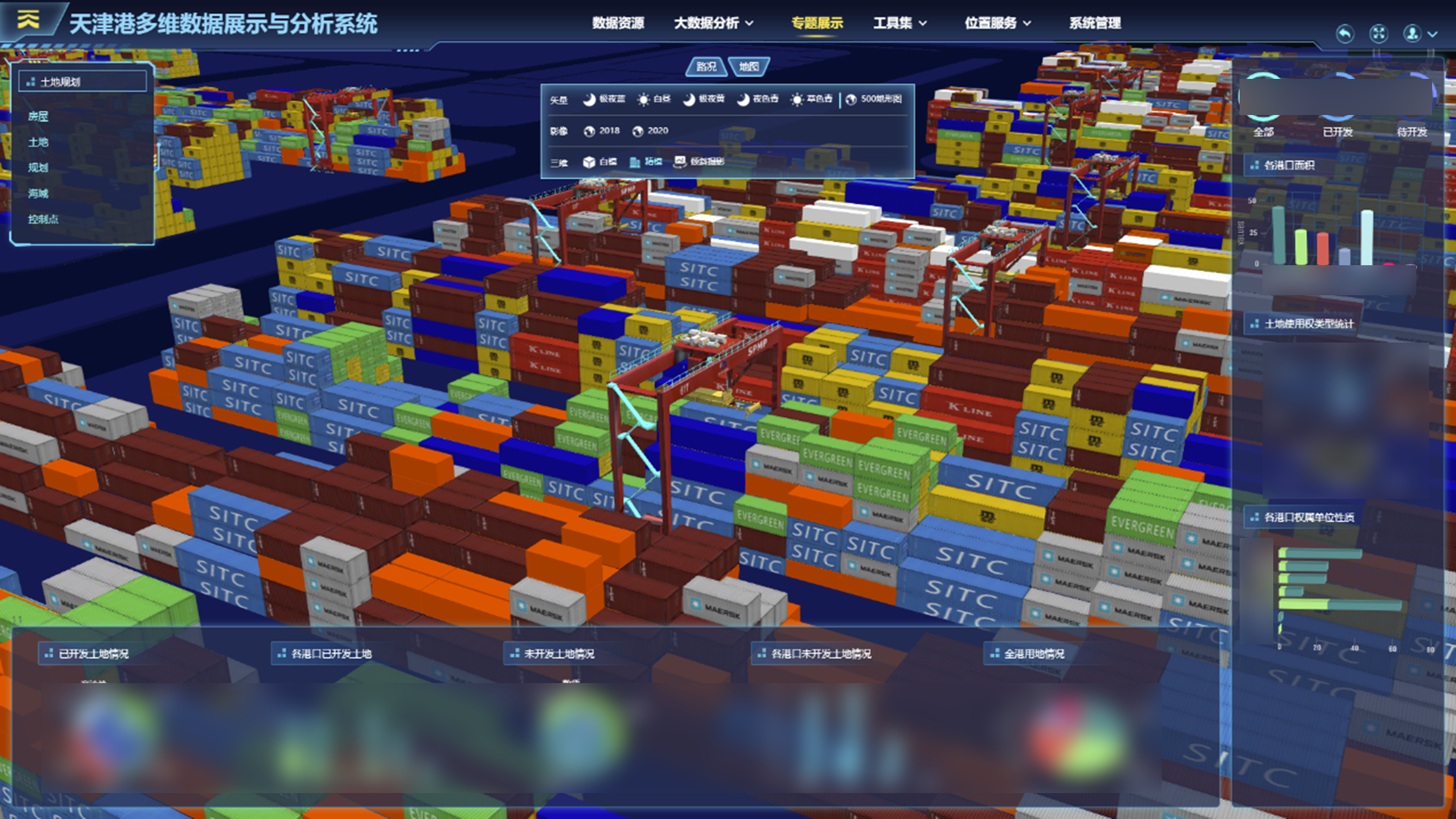
Data display and analysis system
Management: The data management system, operation and maintenance management system, and service management system provide comprehensive management of the geographic information platform and data.
The data management system provides one-stop update, warehousing, mapping, publishing and integrated management of spatio-temporal data; the service management subsystem supports the sharing and exchange of data resources between various departments or units and the mother system; the operation and maintenance management platform is responsible for managing the running status of services and providing support for the normal operation of basic GIS services.
Service management subsystem
Application Building: the platform portal and platform development center support department users at all levels to quickly build business applications
The platform portal ensures the security of the platform and realizes resource sharing and exchange through unified identity authentication. The Platform Development Center provides various development tools to meet the needs of business system construction for units at all levels at the ports.
Assisting port business decision-making to facilitate the construction of smart ports
According to the actual application needs of the planning and land management department of Tianjin Port Group, in the first phase of the system project, developers carried out the development and construction of the Tianjin Port land planning application system, which has realized the streamlined management of land acquisition, storage and transfer, office automation and dynamic management of land care, etc.
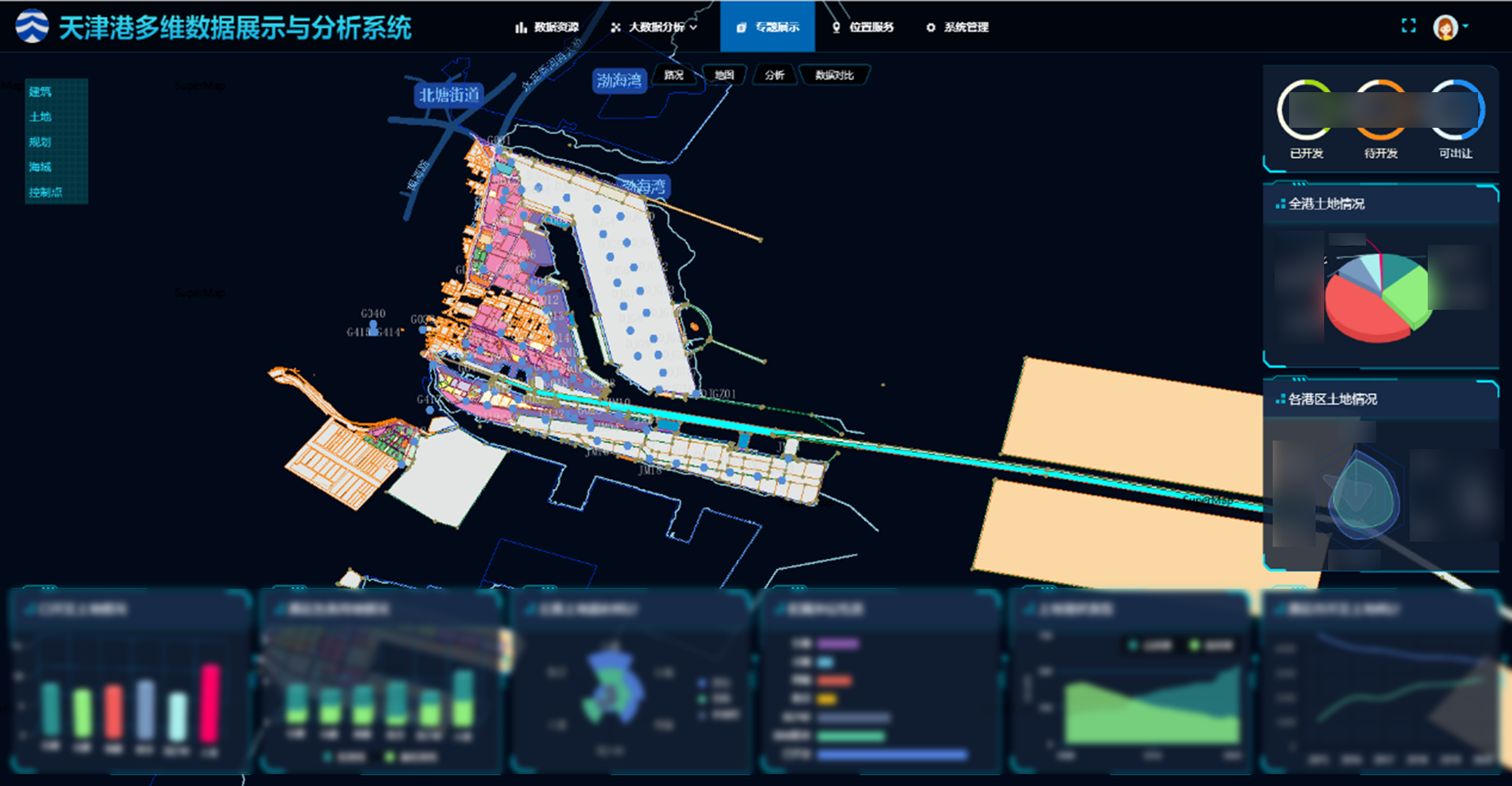
Land planning application system
As an important part of the construction of Smart Tianjin Port, the successful construction of the Tianjin Port Group's Geographical Information Middle Platform has effectively promoted the integration and sharing of geographical information resources and improved the informatization level and comprehensive service capabilities of Tianjin Port as a whole. It has laid a solid foundation for the further construction of smart ports.
At the same time, the successful construction of the platform will promote the interconnection between the port and the upstream and downstream of the supply chain, create a Beijing-Tianjin-Hebei port logistics supply chain service platform that features intelligence, results sharing, connectivity, and smart data, forming a buoyant northern international shipping logistics trade ecosystem.


