Spatial computing platform may become the next generation computing platform
Various extended reality technologies such as VR (Virtual Reality), AR (Augmented Reality), and MR (Mixed Reality) serve as the interface between the real world and the virtual world, providing users with an immersive and hyper-realistic interactive experience. Earlier this year, Apple launched the Vision Pro, the first mixed reality (MR) head-mounted display device. It is a truly revolutionary device that integrates virtuality and reality. As Apple CEO Tim Cook said, Mac brings us into the era of personal computing, iPhone brings us into the era of mobile computing, and Apple Vision Pro will bring us into the era of spatial computing.
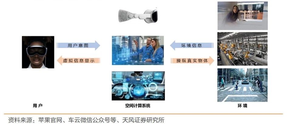
The underlying logic of the spatial computing era is the spatial computing platform. The generalized spatial computing platform is an information-environment coupling system that takes environmental information and user intentions as input, and takes virtual information presented to the user and operating instructions acting on real space objects as output to realize a direct and complex feedback loop, forming an organic system in which people, environment, and spatial computing devices are coupled to each other.
Spatial computing deconstructs and recreates space, making MR equipment a bridge between reality and virtuality, an entrance to a new world of intelligence for all things, and giving birth to a new computing platform. MR devices equipped with spatial computing platforms free up hands and seamlessly integrate digital content into the user's field of vision, providing a more natural and comfortable way of interaction. This also makes spatial computing technology most likely to become the entrance to the future 3D space Internet, completely changing the interaction between people and machines, people and people, and things and things.

The relationship between GIS and spatial computing
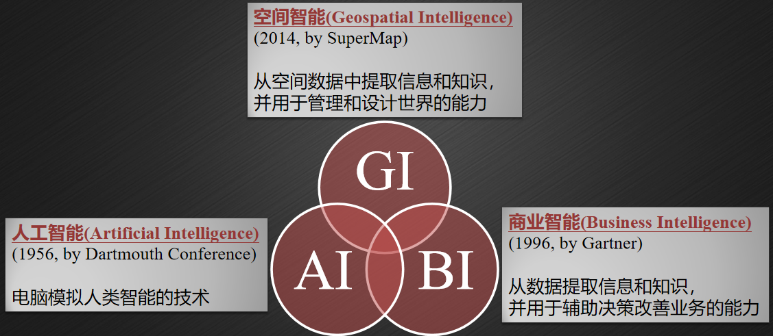
With the development of intelligence in the field of GIS, Geospatial Intelligence was first proposed in 2014, which refers to the ability to extract information and knowledge from spatial data and use it to manage and design the world. In recent years, GIS software has been widely used in the IT field and more and more industries.

AI, BI and GI
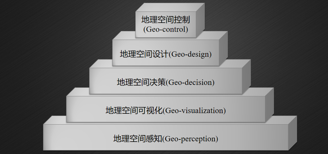
Geospatial intelligence can be embodied as a pyramid structure, with the lowest level being geospatial perception, followed by geo-visualization, geo-decision, geo-design and geo-control. From bottom to top, the level of intelligence is getting higher and higher, and the maturity is getting lower and lower.

Geospatial Intelligence Pyramid (GI Pyramid)
GIS will become the basic support of the spatial computing platform. The five layers of the geospatial intelligence pyramid cover all aspects of GIS applications and will give the spatial computing platform more geospatial intelligence.
01 Geo-perception–information input for spatial computing
In the geo-perception layer, geometric and semantic models of the geographical environment can be established through positioning, mapping and recognition. Geo-perception can realize positioning in complex environments and provide location-related services. Applications based on spatial computing, such as AR navigation and AR multi-person collaboration, are all inseparable from geospatial perception as information input.
02 Geo-visualization-immersive expression of spatial computing
The geospatial visualization layer displays geospatial data through the GIS platform, covering GIS technologies such as 2D and 3D integration, 3D reconstruction technology, etc. The geo-visualization layer is the key technology for virtual reality to express the objective world, so as to achieve precise positioning and seamless integration of virtual reality and reality in real-life scenes.
03 Geo-decision–spatio-temporal analysis capabilities of spatial computing
Based on GIS spatial analysis, the spatial computing platform is endowed with intelligent decision-making capabilities. Through the integration, analysis and processing of geospatial data, the intelligent application of geospatial data can be realized, such as land use changes, wetland degradation and other issues.
04 Geo-design–scene analysis capabilities of spatial computing
Geospatial design is a 3D spatial analysis and calculation on a unified GIS platform. It can provide skyline analysis, slope and aspect analysis and other capabilities in a combination of virtual and real scenarios based on spatial computing, and can assist urban planning and design, municipal management and other applications.
05 Geo-control–the intelligent brain of spatial computing
Geospatial control is a higher-level application on top of geospatial awareness, geospatial visualization, geospatial decision-making, and geospatial design. Based on the perceived spatial information and referring to the geospatial data analysis results, corresponding responses can be made, such as agricultural unmanned machinery production, drone control, traffic light control, etc.
To be continued...