GIS is an important means to achieve rational planning and utilization of land. It can not only perform visual management of land planning, but also realize dynamic management and control, change tracing, and predictive analysis of land planning, provide technical support for the effective use of land resources, and ensure scientific decision-making of land planning, thus improving land use management and control capabilities.
Mobile GIS combined with GPS, wireless network technology, Internet technology, and multimedia technology, etc. can realize browsing, collection, query, management, analysis, monitoring, etc. of various land elements on mobile devices.
SuperMap integrates mobile GIS into land planning and utilization business, solving problems such as unclear division of planning, low land utilization, and illegal land use. By accessing multi-source heterogeneous GIS data, large-volume image loading and quick browsing, and GIS capabilities such as 2D and 3D integration, multi-content data collection, and spatial analysis, SuperMap provides land construction planning, construction land site selection, land supply and post-supply supervision, homestead approval, real estate title confirmation investigation, ecological restoration supervision, and comprehensive law enforcement, supervision and other services to assist in the rational planning and utilization of land and effective supervision and management.
Combining multiple maps into one to realize "one map" of land
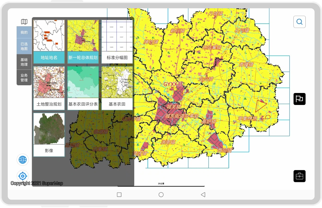
There are various types of maps in land applications, including current land use maps, current road network maps, overall plan maps, land consolidation plan maps, construction land control maps, and mining rights maps, exploration rights maps, land reserve maps, land supply maps, land consolidation maps, etc. In addition, there are also auxiliary maps like image maps, DEM elevation maps, standard frame maps, etc. SuperMap Mobile GIS can integrate all these various maps to create "one map" of land. By controlling the visibility, adjusting the order and the transparency, etc., and matching it with different maps, various types of land information can be visually presented.

Land "One Map"
Split-screen linkage to quickly discover similarities and differences
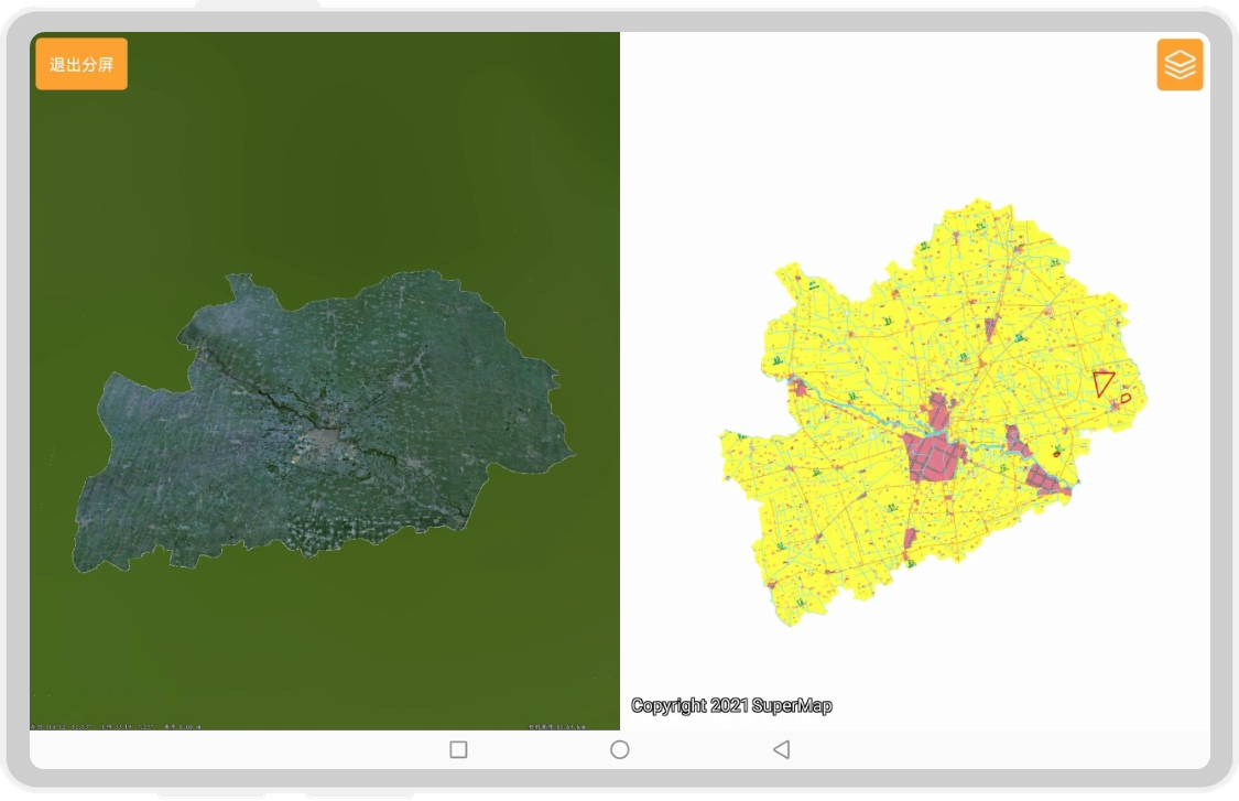
SuperMap Mobile GIS has a split-screen map linkage function. Through linkage browsing of the left and right maps, you can not only compare the land construction planning and land use status in the same time period, understand the construction progress, quickly locate illegal land use, but also compare the land use status at different times, summarizing the construction change trends, and providing scientific reference basis for the new phase of land planning. At the same time, by making full use of the powerful analytical capabilities of two-dimensional maps and the intuitiveness of three-dimensional maps, and conducting two- and three-dimensional integrated split-screen comparisons, the similarities and differences in land supply, reserves, planning, and utilization can be more intuitively presented. With the help of the rolling shutter tool, you can drag the dividing line to easily view the land use development changes in any area.

Comparison of land use situation through 2D and 3D integration
Accurate collection of field polygons with "three in one"
Using the SuperMap mobile GIS terminal as a carrier, field investigators can conduct on-site mapping or verification of land map information. By filling in relevant forms and taking photos for certificates, investigators can quickly grasp first-hand land survey information with the trinity of "map + attribute table + photo". The data collection methods provided by SuperMap Mobile GIS include manual drawing and GNSS collection. During the map drawing process, nodes and line points can be intelligently captured to ensure that the map boundary is clear and accurate. It can also handle adjacent land polygons through segmentation, merging, guiding holes, and other methods to avoid ownership disputes caused by inaccurate shapes.
The collected land parcel information is managed in the form of tasks on the SuperMap mobile GIS terminal, including daily inspection tasks, business approval tasks, dispute mediation tasks, special investigation tasks, comprehensive law enforcement tasks, etc., which can be marked as to-be-done, in-process, or completed so that the task situation is clear at a glance; the terminal also provides attribute query, area query, and point of interest query, realizing linkage between graphs and tables, and quickly locating task map polygons.
SuperMap mobile GIS terminal can also collect and manage the trajectory of field workers in real-time. It can record the trajectory information of field workers throughout the day, and automatically record walking distance and online time. You can view the work track of designated field workers at any time, avoiding backtracking or taking the wrong path. This will provide a strong basis for the performance appraisal of field personnel.
Scientific analysis, and quantitative statistics of land data
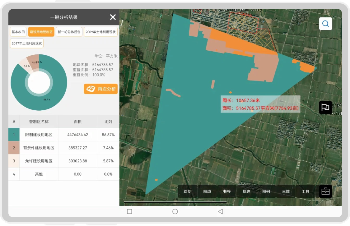
SuperMap Mobile GIS has real-time data analysis and rendering capabilities. It can dynamically display special topics and statistical information based on terminal application requirements and instant changes in data. In land planning applications, superimposing engineering map spots and basic farmland maps can statistically analyze the scope and area of impact of project construction on relevant basic farmland protection zones; superimposing agricultural map spots and construction land control zone maps can statistically analyze whether restricted land is occupied by agricultural production, and the occupation area proportion; superimposing urban residential map spots and overall planning maps can statistically analyze whether residential construction is within the demarcated urban construction land, and whether it occupies basic farmland protection areas and agricultural areas. Through different arrangements and combinations of various maps in the "one map" of land, quantitative statistical results can be obtained.

Statistics and analysis of construction-occupied controlled land
In land planning and management projects, mobile terminals can load and view land business maps of different types and content, compare changes and trends through split screens and rolling shutters, view field surveying, and verify land type map spots, while also using GIS analysis capability. The mobile terminal can also statistically analyze illegal construction land occupation, assisting land planning, construction, and management.
SuperMap Mobile GIS has always been committed to providing users with more advanced and practical mobile GIS technology and services. In the land industry, it has served dozens of projects in land adjustment, linkage increase and decrease, geographical census, cadastral mapping, land resources management and other areas. Welcome to the SuperMap official website to download and try out the SuperMap mobile GIS product.