Remote sensing images are one of the most powerful ways to perceive geographical things on the earth's surface. How to efficiently manage massive remote sensing images, quickly process and analyze them, conveniently distribute and share them, shorten the time from image acquisition to application, improve the reliability and availability of remote sensing data, and provide data services that meet the application needs of various industries have become the key to boosting the development of satellite remote sensing.
SuperMap has released new cross-platform remote sensing image processing desktop software——SuperMap ImageX Pro 2023. It integrates the world's leading photogrammetry algorithms and is based on artificial intelligence, parallel acceleration, cross-platform, and other technologies. It provides geometric correction, area network adjustment, image fusion, image mosaic, DSM generation and filtering, and other core functions using optical satellite remote sensing image data. It can automatically and quickly produce high-precision DOM, and DSM/DEM data, and also provides a variety of basic image processing functions including radiation correction, and image enhancement, etc.
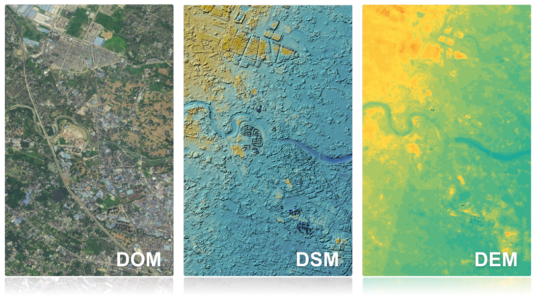
▲Producing high-precision DOM, DSM/DEM data
SuperMap ImageX features cross-platform, intelligent image processing, high computing performance, and integration of remote sensing GIS.
Intelligent image processing
In recent years, artificial intelligence (AI) technology has developed rapidly. However, there are few applications of AI in traditional remote sensing image processing software. SuperMap creatively integrates AI technology into multiple core remote sensing image processing processes, improving the accuracy and quality of the result data.
1. Intelligent geometry processing
Intelligent geometry processing mainly includes two processes: intelligent image matching and intelligent matching point optimization. The first is intelligent image matching. SuperMap ImageX Pro's AI image-matching technology has a built-in AI hetero-source image-matching model. To solve the problem of significant illumination differences in hetero-source images and difficulty in matching, it introduces hetero-source image feature detection and robust feature description methods, which can improve the number and performance of matching points.
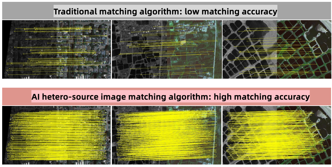
▲Comparison of matching effects between traditional algorithms and AI hetero-source images
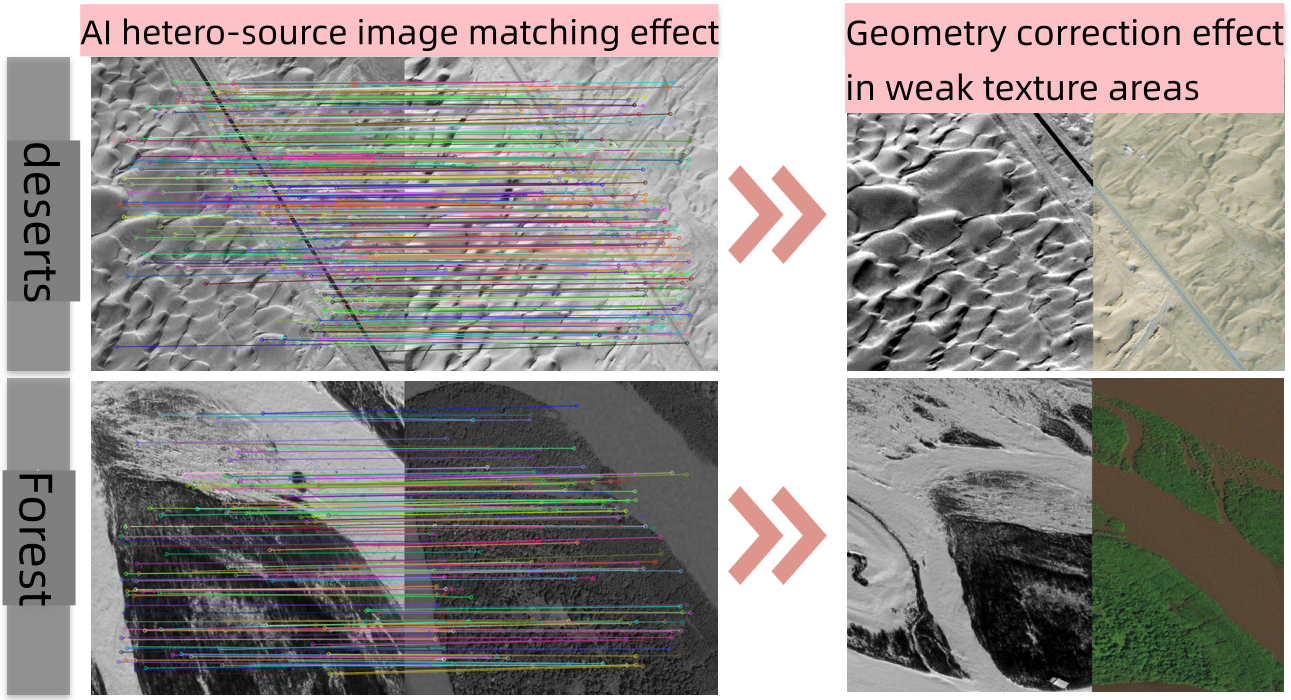
▲ Geometric correction effect based on AI heterogeneous image matching
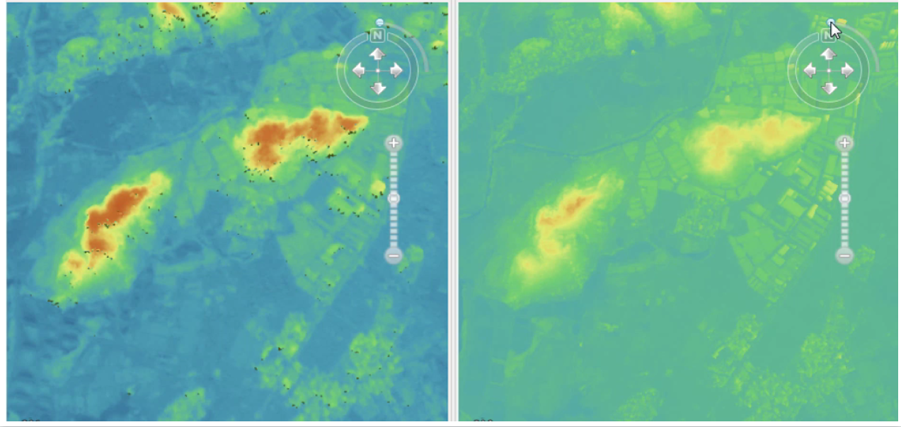
The second is intelligent matching point optimization. If the points obtained by image matching are mostly distributed in areas such as clouds, buildings, water bodies, tall trees, etc., the accuracy of geometric processing will be reduced. SuperMap ImageX Pro introduces AI semantic-assisted geometric processing technology in the geometric correction process. Through built-in multiple AI intelligent interpretation pre-training models, it automatically extracts semantic information and assists in eliminating non-ground points distributed on clouds, buildings, etc. during image matching, thereby improving the accuracy of geometric processing. Especially for urban areas with many buildings, test results show that when AI semantic information is used to assist geometric processing technology, the geometric processing accuracy can be improved by about 0.5 pixels, and the error can be reduced to about 1 pixel.
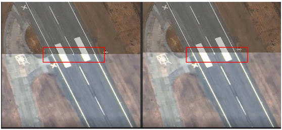
▲ The technical effect of AI semantic-assisted geometric processing (right)
2. Intelligent terrain production
Dense matching and DSM filtering are two core processes in the production of terrain data. SuperMap ImageX Pro introduces AI intelligent terrain data production technology. On the one hand, it can effectively reduce mismatching through the built-in AI dense matching model during the dense matching process, which can not only reduce the generation of valueless areas but also provide higher accuracy and more natural visual effects of DSM with clearer image outline; on the other hand, the built-in AI filtering model can be used to improve the adaptability to complex terrain areas during the filtering process, thereby improving the filtering effect in mountainous and urban areas.
▲The left side shows the effect of using the traditional method: there are many valueless areas; the right adopts the AI method: there are no valueless areas
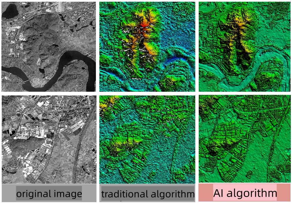
▲Comparison of the effects of intelligent terrain production and traditional production methods
High computing performance
Satellite image production usually requires the processing of large quantities of images, which takes a long time. Therefore, it is necessary to improve image processing efficiency and achieve high-performance automated processing. Based on acceleration technologies such as GPU computing and Accelerated Parallel Processing, SuperMap ImageX Pro achieves high-performance image processing (including generating orthophotos, image fusion, constructing mosaic lines, generating DSM, etc.). Compared with the best software in the same single category, the time is shortened by 30%-70%. The entire process is automated and takes more than 50% less time than the best software of its kind.
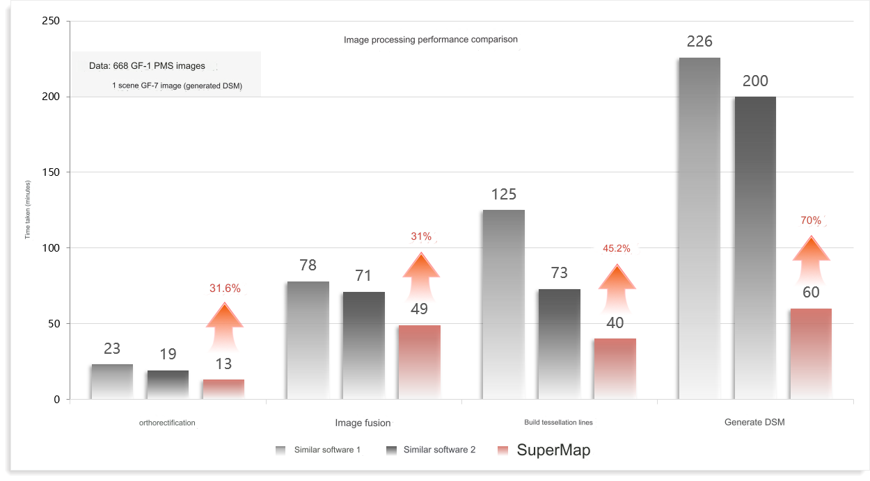
▲Performance comparison of individual core functions
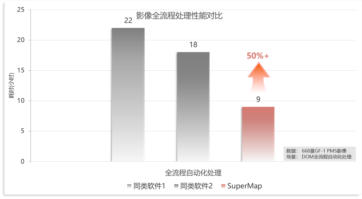
▲Full-process automated processing performance comparison
Remote sensing and GIS integration
Remote sensing technology and GIS technology are inseparable. Both require the management, processing, analysis, and visualization of geospatial data, and their user groups have a high degree of overlap. However, the two have been developed independently for a long time. The spatial data circulation process requires frequent switching of software, and the operation is time-consuming and laborious. Based on remote sensing and GIS integration technology, SuperMap breaks the previous "separation" between remote sensing and GIS, integrates remote sensing and geographic information systems, achieving efficient management and processing of massive remote sensing images, significantly shortening the time from image acquisition to application, which provides more efficient data support for industry application.
The Remote sensing and GIS integration includes management and processing integration, processing and interpretation integration, and processing and release integration. In the production process of remote sensing image data, an intelligent interpretation of images can be added to achieve immediate interpretation; at the same time, image release can be added to the production process to realize the immediate release of remote sensing image data. These methods will help to achieve the T+1 product application dual readiness so that data is obtained on the same day, and put into application the next day.
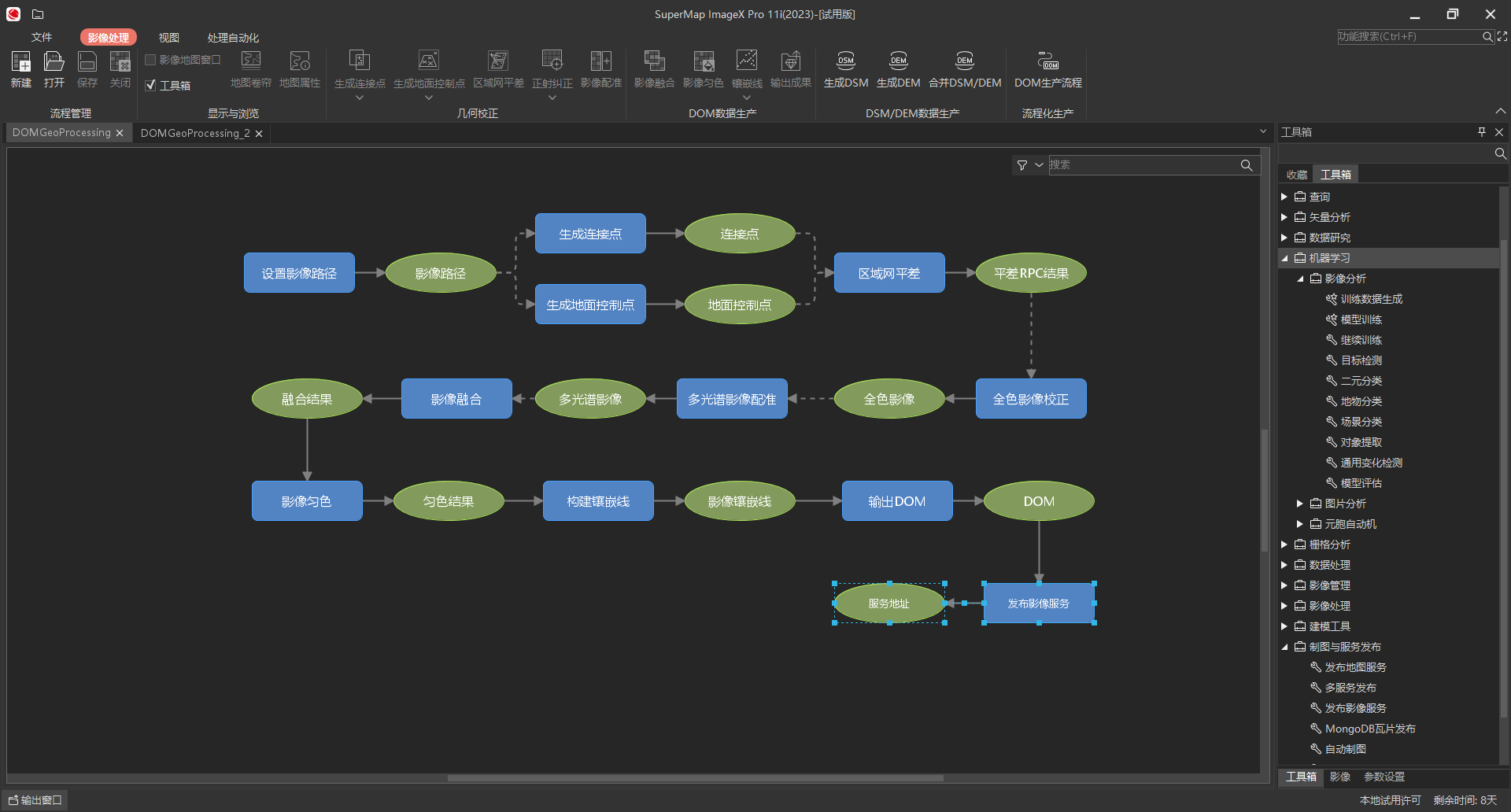
▲Application example of integrated Processing and publishing
SuperMap ImageX Pro is built based on remote sensing and GIS integration technology, featuring cross-platform, intelligent image processing, high computing performance, and integration of remote sensing and GIS. Based on AI, Accelerated Parallel Acceleration, and other technologies, it improves image processing effect and performance. At the same time, remote sensing and GIS integration, and automated processing technology can accelerate the process from data to application, realizing the efficient production and application of remote-sensing image data.


